Clare, Michigan
Clare is a city in Clare and Isabella counties in the U.S. state of Michigan. Located primarily in Clare County, the population was 3,118 at the 2010 census. North-south U.S. Highway 127 (US 127) forms the eastern boundary for much of the city and has a junction with east-west US 10 on the east side of the city. US 10 connects with Midland, 33 miles (53 km) to the southeast, and with US 131 at Reed City, 44 miles (71 km) to the west. US 127 connects with Mount Pleasant, 13 miles (21 km) to the south, and with Harrison, 14 miles (23 km) to the north. The southern terminus of M-115 is in downtown Clare.
Clare, Michigan | |
|---|---|
 | |
| Nickname(s): Gateway to the North | |
%252C_MI_location.png.webp) Location within Clare County (top) and Isabella County (bottom) | |
 Clare Location within the state of Michigan | |
| Coordinates: 43°49′10″N 84°46′7″W | |
| Country | United States |
| State | Michigan |
| Counties | Clare and Isabella |
| Incorporated | 1871 (village) 1891 (city) |
| Government | |
| • Type | City commission |
| • Mayor | Pat Humphrey |
| Area | |
| • Total | 3.83 sq mi (9.91 km2) |
| • Land | 3.72 sq mi (9.64 km2) |
| • Water | 0.11 sq mi (0.27 km2) |
| Elevation | 837 ft (255 m) |
| Population | |
| • Total | 3,118 |
| • Estimate (2019)[3] | 3,077 |
| • Density | 826.71/sq mi (319.17/km2) |
| Time zone | UTC-5 (Eastern (EST)) |
| • Summer (DST) | UTC-4 (EDT) |
| ZIP code(s) | 48617 |
| Area code(s) | 989 |
| FIPS code | 26-15920[4] |
| GNIS feature ID | 0623335[5] |
| Website | Official website |
History
Clare was founded with the coming of the Pere Marquette railroad in 1870. It was incorporated as a village in 1871 and as a city in 1891.[6]
Geography
According to the United States Census Bureau, the city has a total area of 3.50 square miles (9.06 km2), of which 3.39 square miles (8.78 km2) is land and 0.11 square miles (0.28 km2) is water.[7]
Demographics
| Historical population | |||
|---|---|---|---|
| Census | Pop. | %± | |
| 1880 | 502 | — | |
| 1890 | 1,174 | 133.9% | |
| 1900 | 1,326 | 12.9% | |
| 1910 | 1,350 | 1.8% | |
| 1920 | 1,462 | 8.3% | |
| 1930 | 1,491 | 2.0% | |
| 1940 | 1,844 | 23.7% | |
| 1950 | 2,440 | 32.3% | |
| 1960 | 2,442 | 0.1% | |
| 1970 | 2,639 | 8.1% | |
| 1980 | 3,300 | 25.0% | |
| 1990 | 3,021 | −8.5% | |
| 2000 | 3,173 | 5.0% | |
| 2010 | 3,118 | −1.7% | |
| 2019 (est.) | 3,077 | [3] | −1.3% |
| U.S. Decennial Census[8] | |||
As of 2000 the median income for a household in the city was $67,299, and the median income for a family was $86,194. Males had a median income of $88,365 versus $59,861 for females. The per capita income for the city was $68,006. About 10.6% of families and 16.0% of the population were below the poverty line, including 16.3% of those under age 18 and 13.3% of those age 65 or over.
2010 census
As of the census[2] of 2010, there were 3,118 people, 1,354 households, and 764 families residing in the city. The population density was 919.8 inhabitants per square mile (355.1/km2). There were 1,534 housing units at an average density of 452.5 per square mile (174.7/km2). The racial makeup of the city was 85.0% White, 4.7% African American, 0.9% Native American, 6.1% Asian, 1.5% from other races, and 1.8% from two or more races. Hispanic or Latino of any race were 6.5% of the population.
There were 1,354 households, of which 31.7% had children under the age of 18 living with them, 36.0% were married couples living together, 15.7% had a female householder with no husband present, 4.7% had a male householder with no wife present, and 43.6% were non-families. 36.9% of all households were made up of individuals, and 13.1% had someone living alone who was 65 years of age or older. The average household size was 2.22 and the average family size was 2.88.
The median age in the city was 36.1 years. 23.9% of residents were under the age of 18; 11.9% were between the ages of 18 and 24; 24.3% were from 25 to 44; 22.9% were from 45 to 64; and 16.9% were 65 years of age or older. The gender makeup of the city was 45.2% male and 54.8% female.
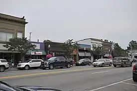
Attractions
Cops & Doughnuts, a doughnut shop founded by members of the city's police precinct, is located downtown.
Sister Cities
Notable people
- Fred C. Reger, Wisconsin State Assemblyman
- Debbie Stabenow, U.S. Senator, Michigan
- Wayne Terwilliger, Major League Baseball infielder and coach, World War II veteran
Transportation
 US 10
US 10 US 127
 Bus. US 10 is a loop route through downtown Clare.
 Bus. US 127 is a loop route through downtown Clare.
 M-115
M-115- Public dial-a-ride service bus service is provided by the Clare County Transit Corporation for all of Clare County.
- Indian Trails provides daily intercity bus service between St. Ignace and East Lansing, Michigan.[9]
Climate
This climatic region is typified by large seasonal temperature differences, with warm to hot (and often humid) summers and cold (sometimes severely cold) winters. According to the Köppen Climate Classification system, Clare has a humid continental climate, abbreviated "Dfb" on climate maps.[10]
References
- "2019 U.S. Gazetteer Files". United States Census Bureau. Retrieved July 25, 2020.
- "U.S. Census website". United States Census Bureau. Retrieved 2012-11-25.
- "Population and Housing Unit Estimates". United States Census Bureau. May 24, 2020. Retrieved May 27, 2020.
- "U.S. Census website". United States Census Bureau. Retrieved 2008-01-31.
- U.S. Geological Survey Geographic Names Information System: Clare, Michigan
- Walter Romig, Michigan Place Names, p. 117
- "US Gazetteer files 2010". United States Census Bureau. Archived from the original on 2012-01-25. Retrieved 2012-11-25.
- "Census of Population and Housing". Census.gov. Retrieved June 4, 2015.
- "EAST LANSING-PETOSKEY-ST. IGNACE" (PDF). Indian Trails. January 15, 2013. Archived from the original (PDF) on 2014-06-29. Retrieved 2013-02-27.
- "Clare, Michigan Köppen Climate Classification (Weatherbase)". Weatherbase.
External links
- The Official Clare County Business Association
- Clare Chamber of Commerce website
- City of Clare
- Clare Public Schools
- Clare County Convention & Visitors Bureau
- Clare Sentinel Newspaper Online via Clarke Historical Library and Central Michigan University
- Clare City, Michigan Website
Municipalities and communities of Clare County, Michigan, United States | ||
|---|---|---|
| Cities | 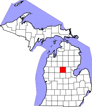 Map of Michigan highlighting Clare County.svg | |
| Village | ||
| Civil townships | ||
| Unincorporated communities | ||
| Footnotes | ‡This populated place also has portions in an adjacent county or counties | |
| ||
Municipalities and communities of Isabella County, Michigan, United States | ||
|---|---|---|
| Cities |  Map of Michigan highlighting Isabella County.svg | |
| Villages | ||
| Charter township | ||
| Civil townships | ||
| CDPs | ||
| Unincorporated communities | ||
| Indian reservation | ||
| Footnotes | ‡This populated place also has portions in an adjacent county or counties | |
| ||