Clarion Township, Bureau County, Illinois
Clarion Township is one of twenty-five townships in Bureau County, Illinois, USA. As of the 2010 census, its population was 421 and it contained 162 housing units.[2]
Clarion Township | |
|---|---|
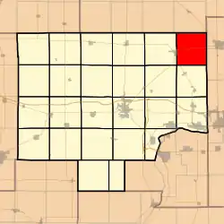 Location in Bureau County | |
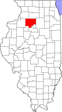 Bureau County's location in Illinois | |
| Coordinates: 41°32′16″N 89°13′31″W | |
| Country | United States |
| State | Illinois |
| County | Bureau |
| Established | November 6, 1849 |
| Area | |
| • Total | 35.35 sq mi (91.6 km2) |
| • Land | 35.35 sq mi (91.6 km2) |
| • Water | 0 sq mi (0 km2) 0% |
| Elevation | 833 ft (254 m) |
| Population (2010) | |
| • Estimate (2016)[1] | 403 |
| • Density | 11.9/sq mi (4.6/km2) |
| Time zone | UTC-6 (CST) |
| • Summer (DST) | UTC-5 (CDT) |
| ZIP codes | 61330, 61342 |
| FIPS code | 17-011-14598 |
Geography
According to the 2010 census, the township has a total area of 35.35 square miles (91.6 km2), all land.[2]
Cities
- La Moille (east quarter)
Unincorporated towns
(This list is based on USGS data and may include former settlements.)Both locations were railroad stations with no residential buildings immediately adjacent. Clarion was a station on what is now the Burlington Northern mainline a few miles southwest of Mendota. No siding or any visible sign of a station exists—and has not since at least 1950. Wendel station was on a Burlington Northern branch line about four miles west of Mendota. A grain elevator (at one time operated by the Wendel family) was the only structure other than nearby farmsteads. The branch railroad was abandoned and all rails removed circa 1975.
Cemeteries
The township contains these five cemeteries: Clarion Lutheran, Erbes, German Evangelical, Hetzler and Hill.
Major highways
Airports and landing strips
- Ivan E Bauer Heliport
- Keutzer Airport
- Otterbach Farm Airport
School districts
- La Moille Community Unit School District 303
- Mendota Elementary District 289
- Mendota High School District 280
Political districts
- Illinois' 11th congressional district
- State House District 76
- State House District 90
- State Senate District 38
- State Senate District 45
References
- "Clarion Township, Bureau County, Illinois". Geographic Names Information System. United States Geological Survey. Retrieved 2010-01-04.
- United States Census Bureau 2007 TIGER/Line Shapefiles
- United States National Atlas
- "Population and Housing Unit Estimates". Retrieved June 9, 2017.
- "Population, Housing Units, Area, and Density: 2010 - County -- County Subdivision and Place -- 2010 Census Summary File 1". United States Census. Archived from the original on 2020-02-12. Retrieved 2013-05-28.
- "Census of Population and Housing". Census.gov. Retrieved June 4, 2016.
External links
Places adjacent to Clarion Township, Bureau County, Illinois | |
|---|---|
Municipalities and communities of Bureau County, Illinois, United States | ||
|---|---|---|
| Cities | Map of Illinois highlighting Bureau County | |
| Villages | ||
| Townships | ||
| Unincorporated communities | ||
| Ghost town | ||
| Footnotes | ‡This populated place also has portions in an adjacent county or counties | |
| ||