List of counties in Illinois
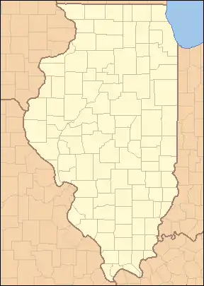
There are 102 counties in the U.S. state of Illinois. The largest of these by population is Cook County, home to Chicago and the second-most populous county in the United States, while the smallest is Hardin County. The largest by area is McLean County while the smallest is Putnam County. Illinois's FIPS state code is 17 and its postal abbreviation is IL.
| Counties of Illinois | |
|---|---|
| |
| Location | State of Illinois |
| Number | 102 |
| Populations | 4,836 (Hardin) – 5,194,675 (Cook) |
| Areas | 160 square miles (410 km2) (Putnam) – 1,184 square miles (3,070 km2) (McLean) |
| Government | County government |
| Subdivisions | 261 Precincts 1,433 Townships |
What is now Illinois was claimed as part of Illinois County, Virginia, between 1778 and 1782. Modern-day county formation dates to 1790 when the area was part of the Northwest Territory; two counties—St. Clair and Knox—were created at that time. Knox would later become a county in Indiana and is unrelated to the current Knox County in Illinois, while St. Clair would become the oldest county in Illinois. 15 counties had been created by the time Illinois achieved statehood in 1818. The last county, Ford County, was created in 1859. Cook County, established in 1831 and named for the early Illinois Attorney General Daniel Pope Cook, contained the absolute majority of the state's population in the first half of the 20th century and retains more than 40% of it as of the 2010 Census.
Most counties in Illinois were named after early American leaders, especially of the American Revolutionary War, as well as soldiers from the Battle of Tippecanoe and the War of 1812. Some are named after natural features or counties in other states. Some are named for early Illinois leaders. Two counties are named for Native American tribes, and one bears the name of a plant used as a food source by Native Americans. While it does have a Lincoln city, Illinois does not have a county named after its favorite son, Abraham Lincoln; it does, however, have a Douglas County (founded 1859) named after his political rival Stephen A. Douglas. It also has Calhoun County (founded 1825), named after John C. Calhoun, outspoken for his pro-slavery and pro-southern views in the years preceding the American Civil War. Several of the counties are named after Southerners, reflecting the fact that Illinois was for a short time part of Virginia, and settled in its early years by many Southerners. No counties are named after heroes of the Civil War, mainly because the counties were all named before that war. The state does have a Lee County (founded 1839) named after the family of Robert E. Lee, who at one time served in Illinois. Illinois also has two counties named after the same person, New York governor DeWitt Clinton (DeWitt County, and Clinton County).
Information on the FIPS county code, county seat, year of establishment, origin, etymology, population, area and map of each county is included in the table below.
Counties
Note: the links in the FIPS County Code column are to the United States Census Bureau page for that county.
| County |
FIPS code[1] | County seat[2] | Est.[2] | Origin | Etymology[3][4] | Population[2] | Area[2] | Map |
|---|---|---|---|---|---|---|---|---|
| Adams County | 001 | Quincy | 1825 | Pike County | John Quincy Adams (1767–1848), sixth President of the United States | 65,691 | 855 sq mi (2,214 km2) | 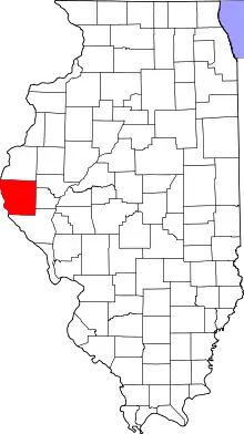 |
| Alexander County | 003 | Cairo | 1819 | Union County | William M. Alexander, settler and state representative in the Illinois General Assembly | 6,060 | 235 sq mi (609 km2) | 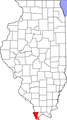 |
| Bond County | 005 | Greenville | 1817 | Crawford County, Edwards County, and Madison County | Shadrach Bond (1773–1832), first Governor of Illinois | 16,630 | 380 sq mi (984 km2) | 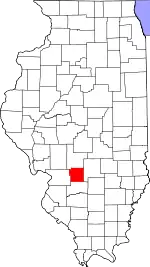 |
| Boone County | 007 | Belvidere | 1837 | Winnebago County | Daniel Boone (1734–1820), trailblazer of the Wilderness Road in Kentucky | 53,577 | 280 sq mi (725 km2) | 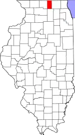 |
| Brown County | 009 | Mount Sterling | 1839 | Schuyler County | Jacob Brown (1775–1828), successful War of 1812 army officer responsible for Great Lakes defenses | 6,556 | 305 sq mi (790 km2) | 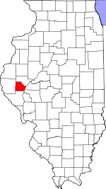 |
| Bureau County | 011 | Princeton | 1837 | Putnam County | Pierre de Bureo, Frenchman, North American fur trader | 32,993 | 869 sq mi (2,251 km2) | 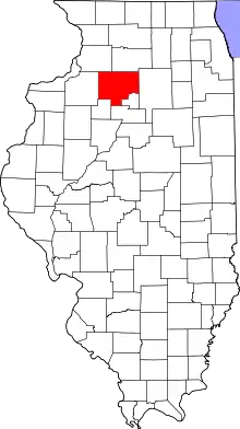 |
| Calhoun County | 013 | Hardin | 1825 | Pike County | John C. Calhoun (1782–1850), South Carolina senator and seventh Vice President of the United States | 4,802 | 253 sq mi (655 km2) | 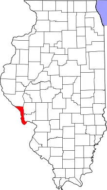 |
| Carroll County | 015 | Mount Carroll | 1839 | Jo Daviess | Charles Carroll of Carrollton (1737–1832), signed the Declaration of Independence on behalf of Maryland | 14,312 | 445 sq mi (1,153 km2) | 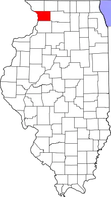 |
| Cass County | 017 | Virginia | 1837 | Morgan County | Lewis Cass (1782–1866), second governor of Michigan Territory, fourteenth United States Secretary of War | 12,260 | 375 sq mi (971 km2) | 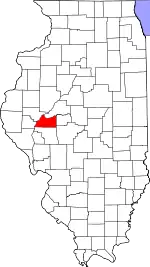 |
| Champaign County | 019 | Urbana | 1833 | Vermilion County | Champaign County, Ohio, which took its name from the French for "open level country" | 209,983 | 996 sq mi (2,580 km2) | 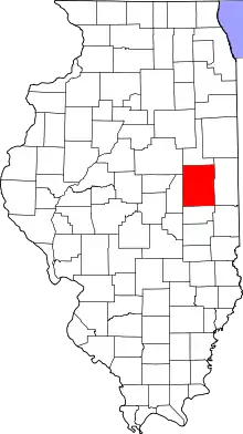 |
| Christian County | 021 | Taylorville | 1839 | Sangamon County | Christian County, Kentucky, which was itself named after Colonel William Christian | 32,661 | 709 sq mi (1,836 km2) | 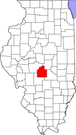 |
| Clark County | 023 | Marshall | 1819 | Crawford County | George Rogers Clark (1752–1818), highest-ranking officer in the Northwest Territory during the American Revolution | 15,596 | 501 sq mi (1,298 km2) | 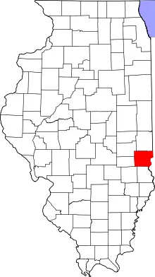 |
| Clay County | 025 | Louisville | 1824 | Wayne, Lawrence, Fayette, and Crawford County | Henry Clay (1777–1852), Kentucky legislator who negotiated the Missouri Compromise | 13,253 | 468 sq mi (1,212 km2) |  |
| Clinton County | 027 | Carlyle | 1824 | Washington, Bond, and Fayette County | DeWitt Clinton (1769–1828), Governor of New York, responsible for the construction of the Erie Canal | 37,639 | 474 sq mi (1,228 km2) |  |
| Coles County | 029 | Charleston | 1830 | Clark and Edgar County | Edward Coles (1786–1868), second Governor of Illinois, responsible for the abolition of slavery in Illinois | 50,885 | 508 sq mi (1,316 km2) | 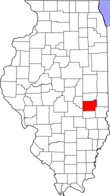 |
| Cook County | 031 | Chicago | 1831 | Putnam County | Daniel Pope Cook (1794–1827), politician and first Attorney General of Illinois | 5,180,493 | 944 sq mi (2,445 km2) | 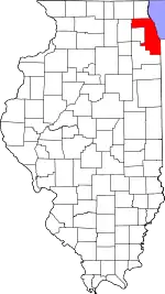 |
| Crawford County | 033 | Robinson | 1816 | Edwards County | William H. Crawford (1772–1834), ninth United States Secretary of War, seventh Secretary of the Treasury | 18,807 | 443 sq mi (1,147 km2) | 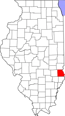 |
| Cumberland County | 035 | Toledo | 1843 | Coles County | Disputed: Cumberland Road, which entered the county; Cumberland, Maryland; or Cumberland River in Kentucky | 10,808 | 345 sq mi (894 km2) | 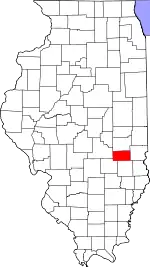 |
| DeKalb County | 037 | Sycamore | 1837 | Kane County | Johann de Kalb (1721–1780), German soldier in the Continental Army who fought alongside Gilbert du Motier, marquis de Lafayette | 104,143 | 631 sq mi (1,634 km2) | 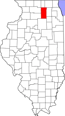 |
| DeWitt County | 039 | Clinton | 1839 | Macon and McLean County | DeWitt Clinton (1769–1828), Governor of New York, responsible for the construction of the Erie Canal | 15,769 | 397 sq mi (1,028 km2) |  |
| Douglas County | 041 | Tuscola | 1859 | Coles County | Stephen A. Douglas (1813–1861), prominent Illinois Democrat who engaged in debates with Abraham Lincoln | 19,479 | 416 sq mi (1,077 km2) | 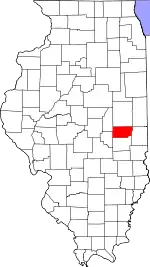 |
| DuPage County | 043 | Wheaton | 1839 | Cook County | DuPage River | 928,589 | 327 sq mi (847 km2) | 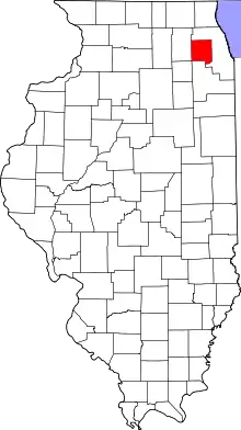 |
| Edgar County | 045 | Paris | 1823 | Clark County | John Edgar (c. 1750–1832), Illinois delegate to the Northwest Territory legislature; at the time, wealthiest man in Illinois | 17,360 | 623 sq mi (1,614 km2) |  |
| Edwards County | 047 | Albion | 1814 | Gallatin County and Madison County | Ninian Edwards (1775–1833), third Governor of the State of Illinois and only governor of the Illinois Territory | 6,392 | 222 sq mi (575 km2) |  |
| Effingham County | 049 | Effingham | 1831 | Fayette and Crawford County | Thomas Howard, 3rd Earl of Effingham, military officer who resigned from the British Army to avoid fighting the American colonies | 34,208 | 478 sq mi (1,238 km2) | 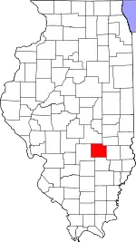 |
| Fayette County | 051 | Vandalia | 1821 | Bond, Wayne, Clark, Jefferson, and Crawford County | Gilbert du Motier, marquis de Lafayette (1757–1834), French military officer who was a key factor in the American and French Revolutions. | 21,416 | 716 sq mi (1,854 km2) |  |
| Ford County | 053 | Paxton | 1859 | Vermilion County | Thomas Ford (1800–1850), eighth Governor of Illinois; served during the Illinois Mormon War | 13,264 | 485 sq mi (1,256 km2) | 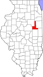 |
| Franklin County | 055 | Benton | 1818 | White County and Gallatin County | Benjamin Franklin (1706–1790), prolific writer, inventor, and politician; key factor in the American Revolution | 38,701 | 408 sq mi (1,057 km2) | 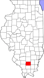 |
| Fulton County | 057 | Lewistown | 1823 | Pike County | Robert Fulton (1765–1815), inventor of the steamboat | 34,844 | 865 sq mi (2,240 km2) | 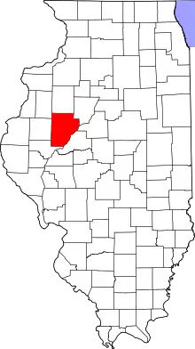 |
| Gallatin County | 059 | Shawneetown | 1812 | Randolph County | Albert Gallatin (1761–1849), fourth and longest-serving United States Secretary of the Treasury | 5,058 | 322 sq mi (834 km2) | 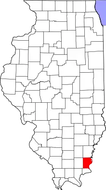 |
| Greene County | 061 | Carrollton | 1821 | Madison County | Nathanael Greene (1742–1786), major general in the Continental Army | 13,044 | 543 sq mi (1,406 km2) | 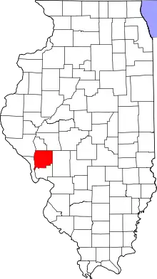 |
| Grundy County | 063 | Morris | 1841 | LaSalle County | Felix Grundy (1777–1840), Tennessean senator who served as the thirteenth United States Attorney General | 50,972 | 418 sq mi (1,083 km2) | 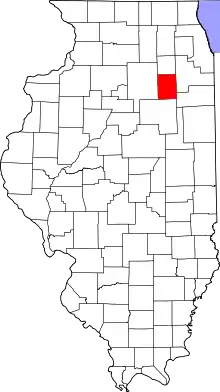 |
| Hamilton County | 065 | McLeansboro | 1821 | White County | Alexander Hamilton (1755–1804), first United States Secretary of the Treasury | 8,163 | 434 sq mi (1,124 km2) | 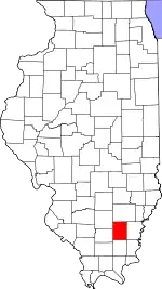 |
| Hancock County | 067 | Carthage | 1825 | Adams County | John Hancock (1737–1793), first governor of the Massachusetts colony and president of the Second Continental Congress | 17,844 | 793 sq mi (2,054 km2) | 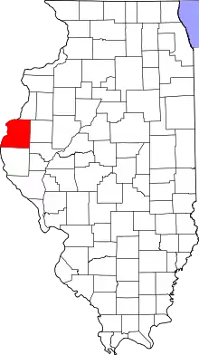 |
| Hardin County | 069 | Elizabethtown | 1839 | Pope County | Hardin County, Kentucky, which was itself named after John Hardin | 3,910 | 177 sq mi (458 km2) |  |
| Henderson County | 071 | Oquawka | 1841 | Warren County | Henderson County, Kentucky, which was itself named after Richard Henderson | 6,709 | 378 sq mi (979 km2) | 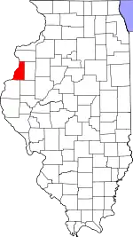 |
| Henry County | 073 | Cambridge | 1825 | Fulton County | Patrick Henry (1736–1799), American Revolutionary War figure; first and sixth Governor of Virginia | 49,090 | 822 sq mi (2,129 km2) | 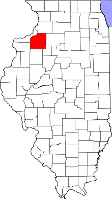 |
| Iroquois County | 075 | Watseka | 1833 | Vermilion County | Iroquois Native Americans | 27,604 | 1,117 sq mi (2,893 km2) | 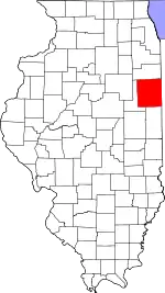 |
| Jackson County | 077 | Murphysboro | 1816 | Randolph County and Johnson County | Andrew Jackson (1767–1845), seventh President of the United States, United States Senator from Tennessee, and general in the War of 1812 | 57,419 | 584 sq mi (1,513 km2) | 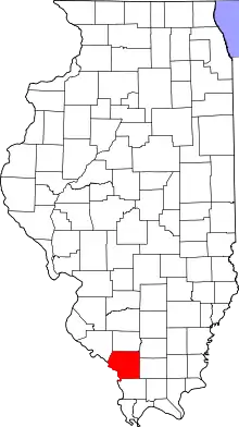 |
| Jasper County | 079 | Newton | 1831 | Clay and Crawford County | Sgt. William Jasper (c. 1750–1779), American Revolutionary War soldier popularized by Parson Weems | 9,611 | 494 sq mi (1,279 km2) | 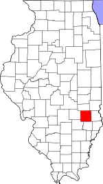 |
| Jefferson County | 081 | Mount Vernon | 1819 | Edwards and White County | Thomas Jefferson (1743–1826), third President of the United States, second Vice President of the United States, Governor of Virginia, and one of the foremost Founding Fathers of the United States | 37,820 | 571 sq mi (1,479 km2) | 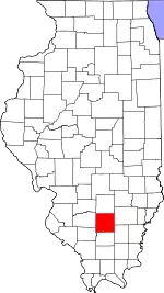 |
| Jersey County | 083 | Jerseyville | 1839 | Greene County | State of New Jersey, from which many early settlers hailed | 21,847 | 369 sq mi (956 km2) | 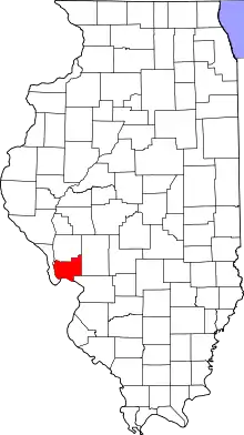 |
| Jo Daviess County | 085 | Galena | 1827 | Henry, Mercer, and Putnam County | Joseph Hamilton Daveiss (1774–1811), commander of the Indiana Dragoons at the Battle of Tippecanoe | 21,366 | 600 sq mi (1,554 km2) | 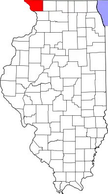 |
| Johnson County | 087 | Vienna | 1812 | Randolph County | Richard Mentor Johnson (c. 1780–1850), ninth Vice President of the United States and United States Senator from Kentucky | 12,456 | 343 sq mi (888 km2) | 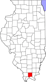 |
| Kane County | 089 | Geneva | 1836 | LaSalle County | Elias Kane (1794–1835), United States Senator from Illinois | 534,216 | 519 sq mi (1,344 km2) |  |
| Kankakee County | 091 | Kankakee | 1853 | Iroquois and Will County | Kankakee River | 110,024 | 676 sq mi (1,751 km2) | 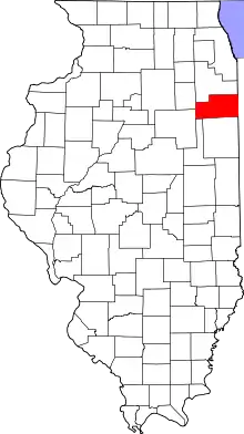 |
| Kendall County | 093 | Yorkville | 1841 | LaSalle and Kane County | Amos Kendall (1789–1869), United States Postmaster General under Presidents Andrew Jackson and Martin Van Buren | 127,915 | 320 sq mi (829 km2) | 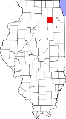 |
| Knox County | 095 | Galesburg | 1825 | Fulton County | Gen. Henry Knox (1750–1806), American Revolutionary War general and first United States Secretary of War | 50,112 | 716 sq mi (1,854 km2) | 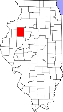 |
| Lake County | 097 | Waukegan | 1839 | McHenry County | Lake Michigan | 700,832 | 443 sq mi (1,147 km2) | 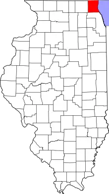 |
| LaSalle County | 099 | Ottawa | 1831 | Putnam and Tazewell County | Sieur de la Salle (1643–1687), French explorer of the Great Lakes | 109,430 | 1,135 sq mi (2,940 km2) | 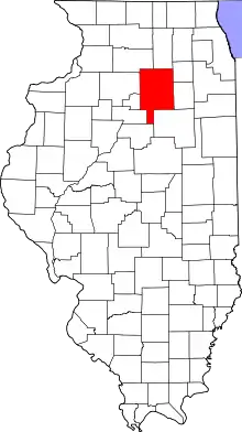 |
| Lawrence County | 101 | Lawrenceville | 1821 | Crawford and Edwards County | Capt. James Lawrence (1781–1813), commander of the USS Chesapeake in the War of 1812. Famous for his command "Don't give up the ship!" | 15,765 | 372 sq mi (963 km2) | 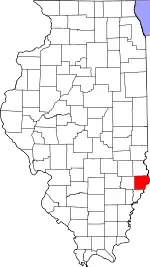 |
| Lee County | 103 | Dixon | 1839 | Ogle County | "Light Horse" Henry Lee III (1756–1818), American Revolutionary War officer and ninth Governor of Virginia | 34,223 | 724 sq mi (1,875 km2) | 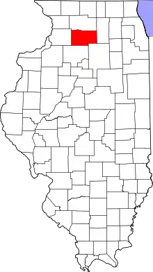 |
| Livingston County | 105 | Pontiac | 1837 | LaSalle and McLean County | Edward Livingston (1764–1836), prominent jurist, Congressman from New York and Louisiana, and U.S. Secretary of State from 1831-33 | 35,761 | 1,043 sq mi (2,701 km2) | 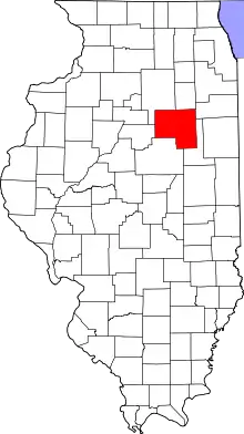 |
| Logan County | 107 | Lincoln | 1839 | Sangamon County | John Logan, country doctor and early settler, and the father of John A. Logan | 28,925 | 618 sq mi (1,601 km2) | 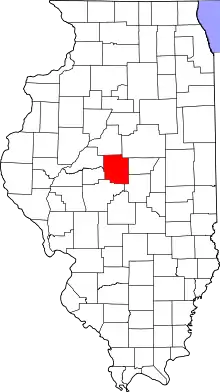 |
| Macon County | 115 | Decatur | 1829 | Shelby County | Nathaniel Macon (1758–1837), sixth Speaker of the United States House of Representatives and United States Senator from North Carolina | 104,712 | 580 sq mi (1,502 km2) | 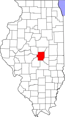 |
| Macoupin County | 117 | Carlinville | 1829 | Greene County | Native American word macoupin, meaning "American lotus" | 45,313 | 862 sq mi (2,233 km2) |  |
| Madison County | 119 | Edwardsville | 1812 | St. Clair County and Randolph County | James Madison (1751–1836), fourth President of the United States and principal author of the Constitution of the United States | 264,461 | 716 sq mi (1,854 km2) | 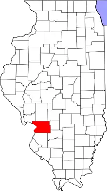 |
| Marion County | 121 | Salem | 1823 | Fayette and Jefferson County | Francis Marion (c. 1732–1795), general in the American Revolutionary War known as "The Swamp Fox" | 37,620 | 572 sq mi (1,481 km2) |  |
| Marshall County | 123 | Lacon | 1839 | Putnam County | John Marshall (1755–1835), fourth and longest-serving Chief Justice of the United States, wrote opinion in Marbury v. Madison establishing the principle of judicial review | 11,534 | 386 sq mi (1,000 km2) | 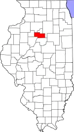 |
| Mason County | 125 | Havana | 1841 | Tazewell and Menard County | Named after Mason County, Kentucky, itself named after George Mason | 13,565 | 539 sq mi (1,396 km2) | 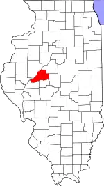 |
| Massac County | 127 | Metropolis | 1843 | Pope and Johnson County | Fort Massac, a colonial-era fort on the Ohio River | 14,080 | 237 sq mi (614 km2) | 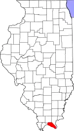 |
| McDonough County | 109 | Macomb | 1826 | Schuyler County | Commodore Thomas Macdonough (1783–1825), commander of American naval forces at the Battle of Plattsburgh | 29,955 | 589 sq mi (1,526 km2) |  |
| McHenry County | 111 | Woodstock | 1836 | Cook and LaSalle County | Major William McHenry (c. 1771–1835), officer during several campaigns against Native Americans and was a member of the Illinois legislature | 308,570 | 603 sq mi (1,562 km2) | 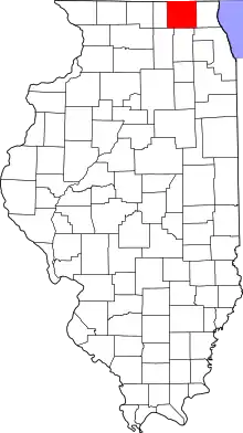 |
| McLean County | 113 | Bloomington | 1830 | Tazewell County | John McLean (1791–1830), United States Representative and United States Senator from Illinois (the latter from 1824-25 and 1829-30) | 172,828 | 1,183 sq mi (3,064 km2) |  |
| Menard County | 129 | Petersburg | 1839 | Sangamon County | Pierre Menard (1766–1844), prominent early settler and first Lieutenant Governor of Illinois | 12,288 | 314 sq mi (813 km2) | 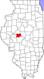 |
| Mercer County | 131 | Aledo | 1825 | Schuyler County | Hugh Mercer (1726–1777), British officer in the Seven Years' War and general in the Continental Army during the American Revolutionary War | 15,601 | 561 sq mi (1,453 km2) | 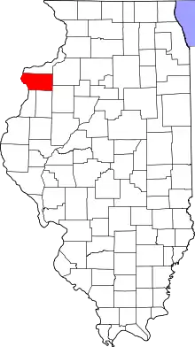 |
| Monroe County | 133 | Waterloo | 1816 | Randolph County and St. Clair County | James Monroe (1758–1831), seventh United States Secretary of State, eighth United States Secretary of War, Governor of Virginia, and fifth President of the United States | 34,335 | 385 sq mi (997 km2) |  |
| Montgomery County | 135 | Hillsboro | 1821 | Bond and Madison County | Gen. Richard Montgomery (1738–1775), brigadier-general in the Continental Army who led the unsuccessful invasion of Canada | 28,601 | 703 sq mi (1,821 km2) | 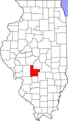 |
| Morgan County | 137 | Jacksonville | 1823 | Sangamon County | Gen. Daniel Morgan (1736–1802), successful tactician in the American Revolutionary War and later United States Representative from Virginia | 33,976 | 568 sq mi (1,471 km2) | 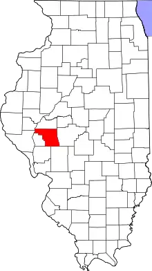 |
| Moultrie County | 139 | Sullivan | 1843 | Shelby and Macon County | Gen. William Moultrie (1730–1805), American Revolutionary War general and Governor of South Carolina | 14,717 | 335 sq mi (868 km2) | 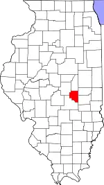 |
| Ogle County | 141 | Oregon | 1836 | Jo Daviess | Joseph Ogle (1737–1821), early settler in southwest Illinois, who helped found the first Methodist church in Illinois | 50,923 | 758 sq mi (1,963 km2) | 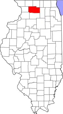 |
| Peoria County | 143 | Peoria | 1825 | Fulton County | The Peoria Native American tribe | 180,621 | 618 sq mi (1,601 km2) | 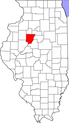 |
| Perry County | 145 | Pinckneyville | 1827 | Randolph and Jackson County | Commodore Oliver Hazard Perry (1785–1819), American naval officer who led the victorious American forces at the Battle of Lake Erie | 21,174 | 441 sq mi (1,142 km2) | 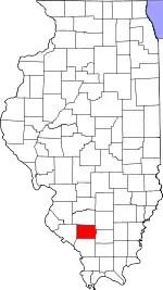 |
| Piatt County | 147 | Monticello | 1841 | DeWitt and Macon County | James A. Piatt, the patriarch of a prominent settler family in the early history of the county | 16,396 | 439 sq mi (1,137 km2) | 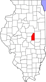 |
| Pike County | 149 | Pittsfield | 1821 | Madison, Bond, and Clark County | Zebulon Pike (1779–1813), early explorer of the American Southwest, namesake of Pikes Peak | 15,611 | 831 sq mi (2,152 km2) | 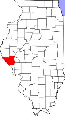 |
| Pope County | 151 | Golconda | 1816 | Gallatin and Johnson County | Nathaniel Pope (1784–1850), early Delegate from Illinois Territory to Congress and judge on the United States District Court for the District of Illinois | 4,212 | 368 sq mi (953 km2) | 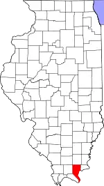 |
| Pulaski County | 153 | Mound City | 1843 | Alexander and Johnson County | Gen. Casimir Pulaski (1745–1779), Polish American general of cavalry in the American Revolutionary War | 5,463 | 199 sq mi (515 km2) | 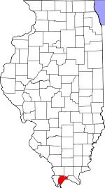 |
| Putnam County | 155 | Hennepin | 1825 | Fulton County | Gen. Israel Putnam (1718–1790), commander of American forces at the Battle of Bunker Hill | 5,740 | 160 sq mi (414 km2) | 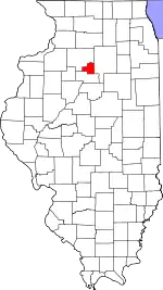 |
| Randolph County | 157 | Chester | 1795 | St. Clair County | Edmund Randolph (1753–1813), first Attorney General of the United States, and briefly United States Secretary of State | 32,106 | 575 sq mi (1,489 km2) | 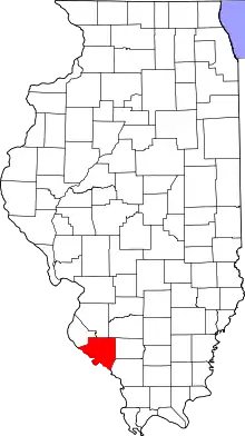 |
| Richland County | 159 | Olney | 1841 | Clay and Lawrence County | Richland County, Ohio, itself named for its rich soil | 15,763 | 360 sq mi (932 km2) | 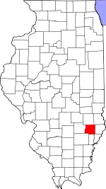 |
| Rock Island County | 161 | Rock Island | 1831 | Jo Daviess County | Rock Island | 143,477 | 427 sq mi (1,106 km2) | 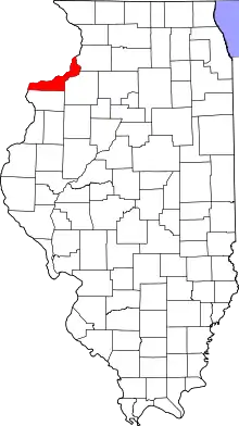 |
| Saline County | 165 | Harrisburg | 1847 | Gallatin County | Salt springs within the county | 23,906 | 379 sq mi (982 km2) | 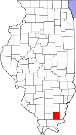 |
| Sangamon County | 167 | Springfield | 1821 | Madison and Bond County | Sangamon River | 195,348 | 868 sq mi (2,248 km2) | 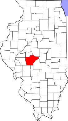 |
| Schuyler County | 169 | Rushville | 1825 | Pike and Fulton County | Gen. Philip Schuyler (1733–1804), American Revolutionary War general and United States Senator from New York | 6,907 | 437 sq mi (1,132 km2) | 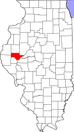 |
| Scott County | 171 | Winchester | 1839 | Morgan County | Scott County, Kentucky, itself named after Charles Scott | 4,926 | 250 sq mi (647 km2) | 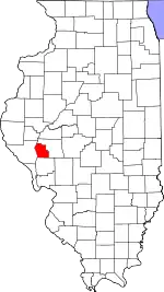 |
| Shelby County | 173 | Shelbyville | 1827 | Fayette County | Isaac Shelby (1750–1826), soldier in the American Revolutionary War and War of 1812; first and fifth Governor of Kentucky | 21,741 | 758 sq mi (1,963 km2) | 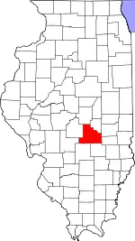 |
| St. Clair County | 163 | Belleville | 1790 | original two counties | Arthur St. Clair (1737–1818), major general in the American Revolutionary War and first Governor of the Northwest Territory | 261,059 | 657 sq mi (1,702 km2) | 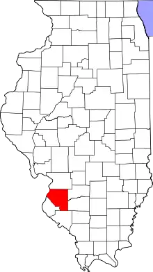 |
| Stark County | 175 | Toulon | 1839 | Knox and Putnam County | Gen. John Stark (1728–1822), general in the American Revolutionary War, called the "Hero of Bennington" | 5,427 | 288 sq mi (746 km2) | 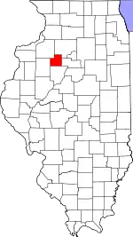 |
| Stephenson County | 177 | Freeport | 1837 | Jo Daviess and Winnebago County | Benjamin Stephenson (1769–1822), representative of Illinois Territory in the United States Congress from 1814 to 1816 | 44,753 | 564 sq mi (1,461 km2) | 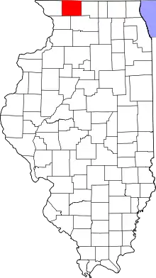 |
| Tazewell County | 179 | Pekin | 1827 | Sangamon County | Littleton Waller Tazewell (1774–1860), United States Senator from (and later governor of) Virginia | 132,328 | 646 sq mi (1,673 km2) | 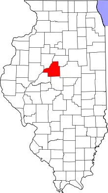 |
| Union County | 181 | Jonesboro | 1818 | Johnson County | The federal union of the states | 16,841 | 413 sq mi (1,070 km2) | 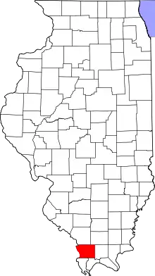 |
| Vermilion County | 183 | Danville | 1826 | Edgar County | The Vermilion River | 76,806 | 898 sq mi (2,326 km2) | 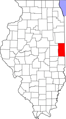 |
| Wabash County | 185 | Mount Carmel | 1824 | Edwards County | The Wabash River | 11,549 | 223 sq mi (578 km2) | 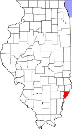 |
| Warren County | 187 | Monmouth | 1825 | Schuyler County | Joseph Warren (1741–1775), played a role in American Patriot movements, a prominent early fatality in the American Revolutionary War | 17,032 | 542 sq mi (1,404 km2) | 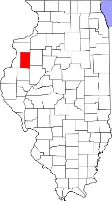 |
| Washington County | 189 | Nashville | 1818 | St. Clair County | George Washington (1732–1799), commander-in-chief of American forces in the American Revolutionary War and first President of the United States | 13,995 | 562 sq mi (1,456 km2) | 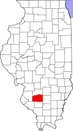 |
| Wayne County | 191 | Fairfield | 1819 | Edwards County | Gen. "Mad" Anthony Wayne (1745–1796), major general in the United States Army in the American Revolutionary War and the Northwest Indian War | 16,332 | 713 sq mi (1,847 km2) | 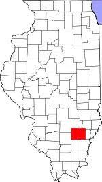 |
| White County | 193 | Carmi | 1815 | Gallatin County | Isaac White (1776–1811), resident of Illinois who enlisted in the Indiana militia and was killed at the Battle of Tippecanoe | 13,665 | 494 sq mi (1,279 km2) | 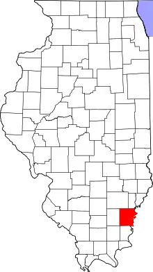 |
| Whiteside County | 195 | Morrison | 1836 | Jo Daviess and Henry County | Samuel Whiteside (1783–1868), state legislator and militia leader | 55,626 | 684 sq mi (1,772 km2) | 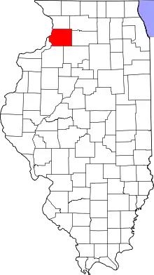 |
| Will County | 197 | Joliet | 1836 | Cook and Iroquois County | Conrad Will (1779–1835),[5] physician, local businessman and longtime member of the state legislature | 692,310 | 835 sq mi (2,163 km2) | 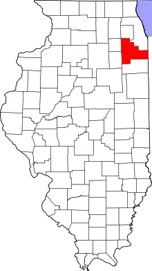 |
| Williamson County | 199 | Marion | 1839 | Franklin County | Hugh Williamson (1735–1819), delegate from North Carolina to the Philadelphia Convention | 67,056 | 420 sq mi (1,088 km2) | 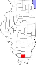 |
| Winnebago County | 201 | Rockford | 1836 | Jo Daviess | Winnebago Native Americans | 284,081 | 513 sq mi (1,329 km2) | 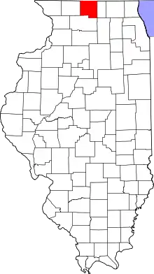 |
| Woodford County | 203 | Eureka | 1841 | Tazewell and McLean County | Gen. William Woodford (1734–1780), brigadier general in the American Revolutionary War who died while a British prisoner | 38,463 | 527 sq mi (1,365 km2) | 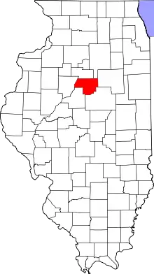 |
Defunct counties
- Dane County was renamed in 1840 to the current Christian County.
- The original Knox County, Illinois, became extinct with the formation of the Illinois Territory in 1809 - or, more precisely, it became Knox County, Indiana. The modern Knox County, Illinois was formed much later and was not a part of the original Knox County.
See also
- List of census-designated places in Illinois
- List of cities in Illinois
- List of Illinois townships
- List of precincts in Illinois
- List of towns and villages in Illinois
- List of unincorporated communities in Illinois
- National Association of Counties
- National Register of Historic Places listings in Illinois
Notes
- "U.S. Census Bureau 2019 FIPS Codes". census.gov. Retrieved January 8, 2021.
- "County Explorer". National Association of Counties. Retrieved January 8, 2021.
- "Illinois County Biographies". Genealogy Trails.com. Genealogy Trails. 2000. Retrieved September 21, 2008.
- "The Origin of Illinois County Names". Genealogy Trails.com. Genealogy Trails. 2000. Retrieved September 21, 2008.
- Matile, Roger (June 22, 2006). "Reflections: Was Dr. Conrad Will really worth his salt?". Ledger-Sentinel. Retrieved October 11, 2011.
References
- Hébert, Michael L. (2012). "Illinois County Boundaries: 1790 - Present". ILGenWeb. Archived from the original on January 26, 2016. Retrieved June 16, 2010.
- White, Jesse (March 2010). "Origin and Evolution of Illinois Counties" (PDF). Illinois Secretary of State.
External links
| Wikimedia Commons has media related to Counties of Illinois. |
- Census 2000 U.S. Gazetteer Files
- Illinois Association of County Board Members
- Illinois Association of County Officials
- Illinois City/County Management Association