Collingdale, Pennsylvania
Collingdale is a borough in Delaware County, Pennsylvania, United States. The population was 8,786, at the 2010 census.
Collingdale, Pennsylvania | |
|---|---|
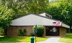 Collingdale Public Library | |
 Location in Delaware County and the U.S. state of Pennsylvania | |
 Collingdale Location in Pennsylvania  Collingdale Location in the United States | |
| Coordinates: 39°54′50″N 75°16′43″W | |
| Mayor | Felecia Coffee (D) |
| Area | |
| • Total | 0.87 sq mi (2.25 km2) |
| • Land | 0.87 sq mi (2.25 km2) |
| • Water | 0.00 sq mi (0.00 km2) |
| Elevation | 95 ft (29 m) |
| Population (2010) | |
| • Total | 8,786 |
| • Estimate (2019)[2] | 8,794 |
| • Density | 10,119.68/sq mi (3,905.09/km2) |
| Time zone | UTC-5 (EST) |
| • Summer (DST) | UTC-4 (EDT) |
| ZIP Code | 19023 |
| Area code(s) | 610 |
| FIPS code | 42-15232 |
| Website | www |
About
Felecia Coffee is the Mayor of Collingdale.
Frank Kelly served twelve consecutive four-year term as Mayor of Collingdale until his passing in November 2018. He served over 47 consecutive years as Mayor of Collingdale. This was the longest consecutive mayoral term in the history of Pennsylvania. The Borough Council appointed Joseph Ciavarelli to fill the vacancy in the office of Mayor after Kelly's death. Ciavarelli lost the 2019 mayoral election to the current mayor, Felecia Coffee.
Southern rock group 38 Special used the Collingdale Police force in making the video for their song "Back Where You Belong". In the video the Collingdale Chief of Police Robert Morris began the video with an homage to the TV show "Hill Street Blues". After giving a short speech, he told the officers: "Let's be careful out there", a signature line from the TV show.. Part of the video was filmed in neighboring Philadelphia under the Walt Whitman Bridge.
The YouTube weather docuseries Storm Sliders is filmed in Collingdale. First started in 2016, the 4th season has been on hiatus since late 2019.
Geography
Collingdale is located at 39°54′50″N 75°16′43″W (39.913889, -75.278647).[3]
According to the United States Census Bureau, the borough has a total area of 0.9 square miles (2.3 km2), all of it land.
Demographics
| Historical population | |||
|---|---|---|---|
| Census | Pop. | %± | |
| 1900 | 603 | — | |
| 1910 | 1,361 | 125.7% | |
| 1920 | 3,834 | 181.7% | |
| 1930 | 7,857 | 104.9% | |
| 1940 | 8,162 | 3.9% | |
| 1950 | 8,443 | 3.4% | |
| 1960 | 10,268 | 21.6% | |
| 1970 | 10,605 | 3.3% | |
| 1980 | 9,539 | −10.1% | |
| 1990 | 9,175 | −3.8% | |
| 2000 | 8,664 | −5.6% | |
| 2010 | 8,786 | 1.4% | |
| 2019 (est.) | 8,794 | [2] | 0.1% |
| Sources:[4][5][6][7] | |||
As of Census 2010, the racial makeup of the borough was 55.9% White, 36.3% African American, 0.3% Native American, 2.9% Asian, 0.8% from other races, and 3.8% from two or more races. Hispanic or Latino of any race were 3.1% of the population .
As of the census[6] of 2000, there were 8,664 people, 3,188 households, and 2,183 families residing in the borough. The population density was 9,995.9 people per square mile (3,845.0/km²). There were 3,404 housing units at an average density of 3,927.3 per square mile (1,510.7/km²). The racial makeup of the borough was 49.36% White, 51.274% African American, 0.29% Native American, 1.62% Asian, 0.01% Pacific Islander, 0.24% from other races, and 1.20% from two or more races. Hispanic or Latino of any race were 0.89% of the population.
There were 3,188 households, out of which 33.9% had children under the age of 18 living with them, 46.0% were married couples living together, 16.5% had a female householder with no husband present, and 31.5% were non-families. 26.8% of all households were made up of individuals, and 10.8% had someone living alone who was 65 years of age or older. The average household size was 2.71 and the average family size was 3.32.
In the borough the population was spread out, with 28.6% under the age of 18, 8.3% from 18 to 24, 31.1% from 25 to 44, 19.0% from 45 to 64, and 13.0% who were 65 years of age or older. The median age was 34 years. For every 100 females there were 94.3 males. For every 100 females age 18 and over, there were 90.4 males.
The median income for a household in the borough was $40,207, and the median income for a family was $47,288. Males had a median income of $38,015 versus $27,955 for females. The per capita income for the borough was $16,751. About 6.9% of families and 8.4% of the population were below the poverty line, including 11.7% of those under age 18 and 3.3% of those age 65 or over.
Education
Students are in the Southeast Delco School District.[8] Most K-8 school residents in Collingdale are zoned to the Harris School, while a few are zoned to Darby Township School.[9] All residents of the school district are zoned to Academy Park High School.
Harris School teaches 771 students from 1st-8th grades in the Southeast Delco School District.
The Roman Catholic Archdiocese of Philadelphia formerly operated St. Joseph School in Collingdale, which closed in 2010. There were 140 prospective children for the 2010-2011 school year that did not happen when the archdiocese wanted 200. Schools taking former St. Joseph's children were Our Lady of Fatima in Secane, St. Eugene in Primos, and St. Gabriel in Norwood.[10]
Transportation

U.S. Route 13 crosses the eastern corner of the borough. MacDade Boulevard (running approximately northeast-southwest), Clifton Avenue, and Woodlawn Avenue (both northwest-southeast) are the principal streets. The SEPTA Route 102 light rail line passes through the borough, with four stops in it. The Media/Elwyn commuter rail line passes nearby to the north; the closest stations are Clifton-Aldan and Primos.[11]
Landmarks
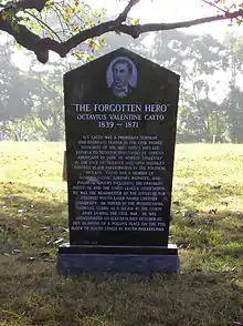
A significant portion of Collingdale's area is made up of four cemeteries, three of which are active. Eden Cemetery is an African-American cemetery, where many notable persons are buried, including singer Marian Anderson, physician Rebecca Cole, and civil rights activist Octavius Catto. It was listed on the National Register of Historic Places in 2010.[12] Har Zion Cemetery and Mt. Lebanon Cemetery are Jewish cemeteries. The fourth, an American Civil War-era cemetery, has been maintained by a local Veterans of Foreign Wars Post.
Felton Ave. is named after W. C. Fields's maternal grandfather, a native of the town when it was part of Darby Township.
References
- "2019 U.S. Gazetteer Files". United States Census Bureau. Retrieved July 28, 2020.
- "Population and Housing Unit Estimates". United States Census Bureau. May 24, 2020. Retrieved May 27, 2020.
- "US Gazetteer files: 2010, 2000, and 1990". United States Census Bureau. 2011-02-12. Retrieved 2011-04-23.
- "Number of Inhabitants: Pennsylvania" (PDF). 18th Census of the United States. U.S. Census Bureau. Retrieved 22 November 2013.
- "Pennsylvania: Population and Housing Unit Counts" (PDF). U.S. Census Bureau. Retrieved 22 November 2013.
- "U.S. Census website". United States Census Bureau. Retrieved 2008-01-31.
- "Annual Estimates of the Resident Population". U.S. Census Bureau. Archived from the original on 2013-11-20. Retrieved 22 November 2013.
- "2010 CENSUS - CENSUS BLOCK MAP: Collingdale borough, PA" (PDF). U.S. Census Bureau. Retrieved 2020-05-04. - Compare to the school district zoning maps.
- "District Map". Southeast Delco School District. Retrieved 2020-05-04. - Compare with borough maps.
- "St. Joseph's School in Collingdale to close". Delco Times. 2020-04-09. Retrieved 2020-05-03.
- Google Maps, Collingdale, PA; accessed 2014.04.09.
- "National Register Information System". National Register of Historic Places. National Park Service. July 9, 2010.
Municipalities and communities of Delaware County, Pennsylvania, United States | ||
|---|---|---|
| City | 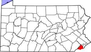 | |
| Boroughs | ||
| Townships | ||
| CDPs | ||
| Unincorporated communities |
| |
| Ghost town | ||
| Footnotes | ‡This populated place also has portions in an adjacent county or counties | |
| ||
| Authority control |
|---|