Parkside, Pennsylvania
Parkside is a borough in Delaware County, Pennsylvania, United States. The population was 2,328 at the 2010 census.[3]
Parkside, Pennsylvania | |
|---|---|
 | |
| Motto(s): "Small but Strong!" | |
 Location in Delaware County and the U.S. state of Pennsylvania. | |
 Parkside Location of Parkside in Pennsylvania  Parkside Parkside (the United States) | |
| Coordinates: 39°52′0″N 75°22′42″W | |
| Country | United States |
| State | Pennsylvania |
| County | Delaware |
| Area | |
| • Total | 0.21 sq mi (0.53 km2) |
| • Land | 0.21 sq mi (0.53 km2) |
| • Water | 0.00 sq mi (0.00 km2) |
| Elevation | 105 ft (32 m) |
| Population (2010) | |
| • Total | 2,328 |
| • Estimate (2019)[2] | 2,330 |
| • Density | 11,310.68/sq mi (4,371.33/km2) |
| Time zone | UTC-5 (EST) |
| • Summer (DST) | UTC-4 (EDT) |
| ZIP code | 19015 |
| Area code(s) | 610 |
| FIPS code | 42-045-58176 |
| FIPS code | 42-58176 |
| GNIS feature ID | 1183333 |
| Website | www |
Geography
Parkside is in southern Delaware County, bordered to the east by Chester, to the south by Upland, and to the west by Brookhaven. Pennsylvania Route 352 (Edgmont Avenue) is the main road through the borough, leading southeast 2 miles (3 km) to the center of Chester and northwest 4 miles (6 km) to U.S. Route 1 near Media.
According to the United States Census Bureau, the borough has a total area of 0.20 square miles (0.53 km2), all of it land.[3]
Demographics
| Historical population | |||
|---|---|---|---|
| Census | Pop. | %± | |
| 1920 | 374 | — | |
| 1930 | 1,497 | 300.3% | |
| 1940 | 1,579 | 5.5% | |
| 1950 | 1,637 | 3.7% | |
| 1960 | 2,426 | 48.2% | |
| 1970 | 2,343 | −3.4% | |
| 1980 | 2,464 | 5.2% | |
| 1990 | 2,369 | −3.9% | |
| 2000 | 2,267 | −4.3% | |
| 2010 | 2,328 | 2.7% | |
| 2019 (est.) | 2,330 | [2] | 0.1% |
| Sources:[4][5][6] | |||
As of Census 2010, the racial makeup of the borough was 80.5% White, 12.9% African American, 0.8% Native American, 2.4% Asian, 0.9% from other races, and 2.4% from two or more races. Hispanic or Latino of any race were 3.5% of the population .
As of the census[5] of 2000, there were 2,267 people, 869 households, and 604 families residing in the borough. The population density was 10,897.8 people per square mile (4,168.1/km2). There were 918 housing units at an average density of 4,413.0 per square mile (1,687.8/km2). The racial makeup of the borough was 95.63% White, 2.43% African American, 0.18% Native American, 0.57% Asian, 0.04% Pacific Islander, 0.35% from other races, and 0.79% from two or more races. Hispanic or Latino of any race were 1.76% of the population.
There were 869 households, out of which 35.7% had children under the age of 18 living with them, 50.3% were married couples living together, 13.7% had a female householder with no husband present, and 30.4% were non-families. 26.2% of all households were made up of individuals, and 10.8% had someone living alone who was 65 years of age or older. The average household size was 2.61 and the average family size was 3.16.
In the borough the population was spread out, with 27.0% under the age of 18, 7.3% from 18 to 24, 33.8% from 25 to 44, 18.6% from 45 to 64, and 13.3% who were 65 years of age or older. The median age was 35 years. For every 100 females there were 95.3 males. For every 100 females age 18 and over, there were 92.3 males.
The median income for a household in the borough was $43,533, and the median income for a family was $48,958. Males had a median income of $40,668 versus $28,563 for females. The per capita income for the borough was $19,448. About 5.0% of families and 5.6% of the population were below the poverty line, including 4.9% of those under age 18 and 14.5% of those age 65 or over.
Education
Parkside is a part of the Penn-Delco School District.
 Fire company
 Parkside Elementary School
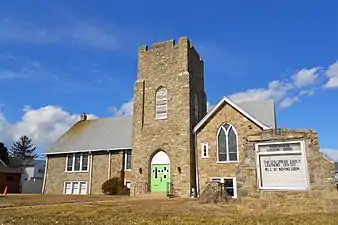 Transformation Christian Center
 Veterans' memorial
References
- "2019 U.S. Gazetteer Files". United States Census Bureau. Retrieved July 28, 2020.
- "Population and Housing Unit Estimates". United States Census Bureau. May 24, 2020. Retrieved May 27, 2020.
- "Geographic Identifiers: 2010 Demographic Profile Data (G001): Parkside borough, Pennsylvania". U.S. Census Bureau, American Factfinder. Archived from the original on February 13, 2020. Retrieved December 28, 2015.
- "Census of Population and Housing". U.S. Census Bureau. Retrieved 11 December 2013.
- "U.S. Census website". United States Census Bureau. Retrieved 2008-01-31.
- "Incorporated Places and Minor Civil Divisions Datasets: Subcounty Resident Population Estimates: April 1, 2010 to July 1, 2012". Population Estimates. U.S. Census Bureau. Archived from the original on June 11, 2013. Retrieved 11 December 2013.
External links
| Wikimedia Commons has media related to Parkside, Pennsylvania. |
Municipalities and communities of Delaware County, Pennsylvania, United States | ||
|---|---|---|
| City | 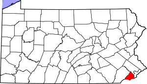 | |
| Boroughs | ||
| Townships | ||
| CDPs | ||
| Unincorporated communities |
| |
| Ghost town | ||
| Footnotes | ‡This populated place also has portions in an adjacent county or counties | |
| ||
| Authority control |
|---|