Brush, Colorado
The City of Brush is a Statutory City located in Morgan County, Colorado, United States. Brush is a part of the Fort Morgan, CO Micropolitan Statistical Area. The city population was 5,463 at the 2010 United States Census.
Brush, Colorado | |
|---|---|
Statutory City[1] | |
| City of Brush[1] | |
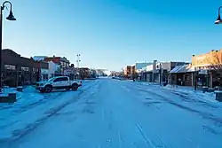 Brush, Colorado. | |
 Location of the City of Brush in Morgan County, Colorado. | |
 Brush Location of the City of Brush in the United States. | |
| Coordinates: 40°15′29″N 103°37′56″W[2] | |
| Country | |
| State | |
| County | Morgan County[3] |
| City | Brush[1] |
| Incorporated | November 24, 1884[4] |
| Government | |
| • Type | Statutory City[1] |
| Area | |
| • Total | 2.83 sq mi (7.34 km2) |
| • Land | 2.83 sq mi (7.33 km2) |
| • Water | 0.00 sq mi (0.01 km2) |
| Elevation | 4,239 ft (1,292 m) |
| Population (2010) | |
| • Total | 5,463 |
| • Estimate (2019)[6] | 5,420 |
| • Density | 1,914.52/sq mi (739.28/km2) |
| Time zone | UTC-7 (MST) |
| • Summer (DST) | UTC-6 (MDT) |
| ZIP code | 80723[7] |
| Area code(s) | 970 |
| FIPS code | 08-09555 |
| GNIS feature ID | 2409926[2] |
| Website | City of Brush |
History
Brush, Colorado was named for Jared L. Brush, who was a Colorado cattle pioneer. Brush had never lived in Brush, Colorado, instead helping to settle what is now known as Greeley. Brush later served as Lieutenant Governor of Colorado, and liked to visit "his town" often.[8]
The town was incorporated by election in 1884.[9]
Geography
Brush is located at 40°15′29″N 103°37′56″W (40.2581366, -103.6321598).[2]
According to the United States Census Bureau, the city has a total area of 2.4 square miles (6.2 km2), all of it land.
Climate
According to the Köppen Climate Classification system, Brush has a semi-arid climate, abbreviated "BSk" on climate maps.
| Climate data for Brush, Colorado | |||||||||||||
|---|---|---|---|---|---|---|---|---|---|---|---|---|---|
| Month | Jan | Feb | Mar | Apr | May | Jun | Jul | Aug | Sep | Oct | Nov | Dec | Year |
| Average high °C (°F) | 4 (39) |
6 (43) |
10 (50) |
16 (60) |
21 (70) |
27 (81) |
32 (89) |
31 (87) |
26 (79) |
19 (66) |
10 (50) |
6 (42) |
17 (63) |
| Average low °C (°F) | −11 (12) |
−9 (16) |
−6 (22) |
−1 (31) |
6 (42) |
11 (51) |
14 (58) |
13 (56) |
8 (47) |
2 (35) |
−6 (22) |
−9 (15) |
1 (34) |
| Average precipitation mm (inches) | 10 (0.4) |
13 (0.5) |
25 (1) |
46 (1.8) |
74 (2.9) |
64 (2.5) |
71 (2.8) |
48 (1.9) |
38 (1.5) |
25 (1) |
15 (0.6) |
15 (0.6) |
440 (17.5) |
| Source: Weatherbase[10] | |||||||||||||
Demographics
| Historical population | |||
|---|---|---|---|
| Census | Pop. | %± | |
| 1890 | 112 | — | |
| 1900 | 381 | 240.2% | |
| 1910 | 997 | 161.7% | |
| 1920 | 2,103 | 110.9% | |
| 1930 | 2,312 | 9.9% | |
| 1940 | 2,481 | 7.3% | |
| 1950 | 2,431 | −2.0% | |
| 1960 | 3,621 | 49.0% | |
| 1970 | 3,377 | −6.7% | |
| 1980 | 4,082 | 20.9% | |
| 1990 | 4,165 | 2.0% | |
| 2000 | 5,117 | 22.9% | |
| 2010 | 5,463 | 6.8% | |
| 2019 (est.) | 5,420 | [6] | −0.8% |
| U.S. Decennial Census[11] | |||
As of the census[12] of 2000, there were 5,117 people, 1,836 households, and 1,233 families residing in the city. The population density was 2,120.0 people per square mile (819.8/km2). There were 1,923 housing units at an average density of 796.7 per square mile (308.1/km2). The racial makeup of the population in the city was 75.81% White, 0.39% African American, 0.51% Native American, 0.16% Asian, 0.04% Pacific Islander, 20.19% from other races, and 2.91% from two or more races. Hispanic or Latino of any race were 50.00% of the population.
There were 1,836 households, out of which 35.1% had children under the age of 18 living with them, 53.8% were married couples living together, 9.6% had a female householder with no husband present, and 32.8% were non-families. 28.6% of all households were made up of individuals, and 15.2% had someone living alone who was 65 years of age or older. The average household size was 2.64 and the average family size was 3.29.
In the city, the population was spread out, with 28.3% under the age of 18, 8.5% from 18 to 24, 25.7% from 25 to 44, 18.7% from 45 to 64, and 18.8% who were 65 years of age or older. The median age was 35 years. For every 100 females, there were 91.6 males. For every 100 females age 18 and over, there were 88.3 males.
The median income for a household in the city was $31,333, and the median income for a family was $39,094. Males had a median income of $24,431 versus $20,371 for females. The per capita income for the city was $14,672. About 5.4% of families and 10.4% of the population were below the poverty line, including 10.1% of those under age 18 and 13.1% of those age 65 or over.
Culture
Agriculture and ranching make up a large part of the local economy. The Brush Rodeo, known as the largest amateur rodeo in the world, is held each July. The Morgan County Fair showcases the community's 4-H projects and livestock.
The Brush Industrial Park contains a 272-bed prison in a correctional complex that has been vacant since 2010. In 2017, plans were to use an outbuilding as a treatment center for autistic spectrum disorders.[13]
The Brush High School mascot is the Beetdigger,[14] signifying the importance of the annual sugar beet crop. The football team, winner of multiple state championships, plays its games at Beetdigger Stadium.
Education
School District
- Brush School District Re 2J
Elementary schools
- Thomson Elementary School
•Address: 422 Ray Street
- Beaver Valley Elementary School
•Address: 2710 Mill Street
Combined Secondary Campus
- Brush Secondary Campus
•Address: 400 West Avenue
Transportation
Major Highways
 Interstate 76 connects Brush to Denver, located 93 miles southwest. To the northeast, Brush is linked with Interstate 80 in Big Springs, Nebraska, via Sterling, Colorado.
 Business Loop 76 runs on Edison Street, reaching Fort Morgan in its west end.
 US 6 connects Provincetown, Massachusetts to Bishop, California, via Nevada, Colorado, Illinois and 9 other states.
 US 34 links Granby, Colorado with Berwyn, Illinois, passing through Nebraska and Iowa. In Colorado, it connects Brush to Greeley and Loveland.
 State Highway 71 runs from US 350, near La Junta to Nebraska state border, where it becomes Nebraska Highway 71.
Local notables
- Pat Day, 1992 Kentucky Derby winner and a member of the jockey Hall of Fame, was born in Brush.
See also
- Colorado cities and towns
- Morgan County, Colorado
- Colorado metropolitan areas
- Fort Morgan, CO Micropolitan Statistical Area
References
- "Active Colorado Municipalities". State of Colorado, Colorado Department of Local Affairs, Division of Local Government. Retrieved January 28, 2021.
- U.S. Geological Survey Geographic Names Information System: Brush, Colorado
- "Colorado Counties". State of Colorado, Colorado Department of Local Affairs, Division of Local Government. Retrieved January 28, 2021.
- "Colorado Municipal Incorporations". State of Colorado, Department of Personnel & Administration, Colorado State Archives. 2004-12-01. Retrieved 2007-09-02.
- "2019 U.S. Gazetteer Files". United States Census Bureau. Retrieved July 1, 2020.
- "Population and Housing Unit Estimates". United States Census Bureau. May 24, 2020. Retrieved May 27, 2020.
- "ZIP Code Lookup". United States Postal Service. Archived from the original (JavaScript/HTML) on September 3, 2007. Retrieved September 4, 2007.
- "Our History". City of Brush!. Retrieved 2012-05-07.
- "Brush, Colorado". City-Data.com. Retrieved 2012-05-07.
- "Weatherbase.com". Weatherbase. 2013. Retrieved on September 29, 2013.
- "Census of Population and Housing". Census.gov. Retrieved June 4, 2015.
- "U.S. Census website". United States Census Bureau. Retrieved 2008-01-31.
- Converge School sets sights on former Brush prison site, Brush News-Tribune, Katie Collins, November 28, 2016. Retrieved 28 April 2017.
- http://www.hometeamsonline.com/teams/?u=BRUSHBBK&t=c&s=basketball&p=about
External links
Municipalities and communities of Morgan County, Colorado, United States | ||
|---|---|---|
| Cities | 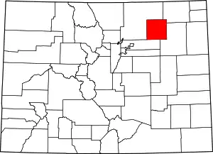 Map of Colorado highlighting Morgan County | |
| Towns | ||
| CDPs | ||
| Unincorporated communities |
| |
| Ghost towns | ||
| ||

| Authority control |
|---|