Compton Abbas
Compton Abbas is a village and civil parish in north Dorset, England. It lies 3 miles (5 kilometres) south of the town of Shaftesbury. It is sited on greensand strata on the edge of the Blackmore Vale,[2] below the chalk downs of Cranborne Chase. On top of these hills is Compton Abbas Airfield. The A350 road between Wiltshire and the south coast passes through the village. In the 2011 census the civil parish had a population of 216.[1] The name Compton Abbas derives from the Saxon "cumb-ton", meaning 'village in a narrow valley', plus "abbas" which refers to Shaftesbury Abbey (the land was owned by the abbess). The church, St. Mary's, was built in 1866 to replace the older structure which was more remote from the village.
| Compton Abbas | |
|---|---|
 St Mary's Church, Compton Abbas | |
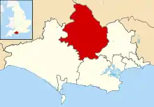
 Compton Abbas Location within Dorset | |
| Population | 216 (2011)[1] |
| OS grid reference | ST869184 |
| Civil parish |
|
| Unitary authority | |
| Ceremonial county | |
| Region | |
| Country | England |
| Sovereign state | United Kingdom |
| Post town | SHAFTESBURY |
| Postcode district | SP7 |
| Dialling code | 01747 |
| Police | Dorset |
| Fire | Dorset and Wiltshire |
| Ambulance | South Western |
| UK Parliament | |
The tower of the Church of St Mary in East Compton is a Grade I listed building.
References
- "Area: Compton Abbas (Parish), Key Figures for 2011 Census: Key Statistics". Neighbourhood Statistics. Office for National Statistics. Retrieved 4 July 2014.
- Ralph Wightman (1983). Portrait of Dorset (4 ed.). Robert Hale Ltd. p. 16. ISBN 0-7090-0844-9.
External links
![]() Media related to Compton Abbas at Wikimedia Commons
Media related to Compton Abbas at Wikimedia Commons