Cotonou
Cotonou (French pronunciation: [kɔtɔnu]; Fon: Kútɔ̀nú)[2] is the economic center of Benin. Its official population count was 761,137 inhabitants in 2006; however, some estimates indicate its population to be as high as 2.4 million. The population in 1960 was only 70,000. The urban area continues to expand, notably toward the west. The city lies in the southeast of the country, between the Atlantic Ocean and Lake Nokoué.[3]
Cotonou | |
|---|---|
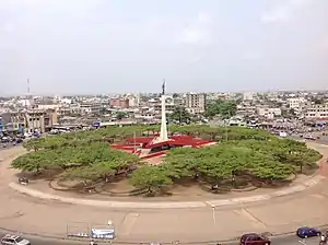
 View of downtown Cotonou in 2019 | |
 Cotonou Location of Cotonou in Benin | |
| Coordinates: 6°22′N 2°26′E | |
| Country | |
| Department | Littoral Department |
| Government | |
| • Mayor | Léhady Soglo |
| Area | |
| • Total | 79 km2 (31 sq mi) |
| Elevation | 51 m (167 ft) |
| Population (2017)[1] | |
| • Total | 2,401,067 |
| • Density | 30,000/km2 (79,000/sq mi) |
In addition to being Benin's largest city, it is the seat of government, although Porto-Novo is the official capital. It is home to most of the country's government buildings and diplomatic services.
History
.jpg.webp)
The name "Cotonou" means "by the river of death" in the Fon language.[4] At the beginning of the 19th century, Cotonou (then spelled "Kutonou") was a small fishing village, and is thought to have been formally founded by King Ghezo of Dahomey in 1830.[4] It grew as a centre for the slave trade, and later palm oil and cotton.[4] In 1851 the French Second Republic made a treaty with King Ghezo that allowed them to establish a trading post at Cotonou. During the reign of King Glele (1858–89), the territory was ceded to the Second French Empire by a treaty signed in 1878.[5] In 1883, the French Navy occupied the city to prevent British conquest of the area. After Glele's death in 1889, King Béhanzin unsuccessfully tried to challenge the treaty. The town grew rapidly following the building of the harbour in 1908.[4]
Geography
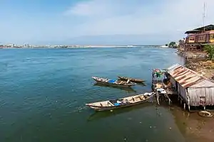
Cotonou is on the coastal strip between Lake Nokoué and the Atlantic Ocean. The city is cut in two by a canal, the lagoon of Cotonou, dug by the French in 1855. Three bridges are in this area. The Ouémé River flows into the Atlantic Ocean at Cotonou.
The city has established transportation infrastructure including air, sea, river (to Porto Novo), and land routes that facilitate trade with its neighbors Nigeria, Niger, Burkina Faso, and Togo.
Coastal erosion has been noted for several decades. It worsened in 1961 following construction of the Nangbeto Dam and deep-water port of Cotonou. A pilot project funded by the United Nations Environment Program (UNEP) revealed that in 40 years, the coast to the east of Cotonou had retreated by 400 meters.[6] This erosion has led many people to leave their homes along the coast.[7]
Climate
Under Köppen's climate classification, Cotonou features a tropical wet and dry climate, alternating with two rainy seasons (April–July and September–October, 800 to 1,200 mm (47 in) of rain per year) and two dry seasons. In December and January, the city is affected by harmattan winds. Temperatures are relatively constant throughout the year, with the average high temperatures hovering around 30 °C (86 °F), and average low temperatures at around 25 °C (77 °F).
| Climate data for Cotonou (1961–1990, extremes 1910–present) | |||||||||||||
|---|---|---|---|---|---|---|---|---|---|---|---|---|---|
| Month | Jan | Feb | Mar | Apr | May | Jun | Jul | Aug | Sep | Oct | Nov | Dec | Year |
| Record high °C (°F) | 36.1 (97.0) |
38.6 (101.5) |
36.0 (96.8) |
35.4 (95.7) |
39.0 (102.2) |
33.0 (91.4) |
33.5 (92.3) |
31.8 (89.2) |
31.6 (88.9) |
33.4 (92.1) |
35.4 (95.7) |
36.6 (97.9) |
39.0 (102.2) |
| Average high °C (°F) | 30.8 (87.4) |
31.6 (88.9) |
31.9 (89.4) |
31.6 (88.9) |
31.0 (87.8) |
29.2 (84.6) |
28.0 (82.4) |
27.8 (82.0) |
28.4 (83.1) |
29.6 (85.3) |
30.9 (87.6) |
30.8 (87.4) |
30.1 (86.2) |
| Daily mean °C (°F) | 27.3 (81.1) |
28.5 (83.3) |
28.9 (84.0) |
28.6 (83.5) |
27.8 (82.0) |
26.5 (79.7) |
25.8 (78.4) |
25.6 (78.1) |
26.0 (78.8) |
26.7 (80.1) |
27.6 (81.7) |
27.3 (81.1) |
27.2 (81.0) |
| Average low °C (°F) | 23.8 (74.8) |
25.4 (77.7) |
25.9 (78.6) |
25.6 (78.1) |
24.6 (76.3) |
23.7 (74.7) |
23.7 (74.7) |
23.4 (74.1) |
23.6 (74.5) |
23.8 (74.8) |
24.3 (75.7) |
23.8 (74.8) |
24.3 (75.7) |
| Record low °C (°F) | 17.0 (62.6) |
17.9 (64.2) |
18.5 (65.3) |
20.7 (69.3) |
19.6 (67.3) |
20.0 (68.0) |
18.8 (65.8) |
19.8 (67.6) |
20.0 (68.0) |
19.1 (66.4) |
21.0 (69.8) |
17.9 (64.2) |
17.0 (62.6) |
| Average precipitation mm (inches) | 9.2 (0.36) |
36.8 (1.45) |
73.8 (2.91) |
137.0 (5.39) |
196.9 (7.75) |
356.0 (14.02) |
147.0 (5.79) |
64.9 (2.56) |
99.0 (3.90) |
126.7 (4.99) |
41.4 (1.63) |
19.6 (0.77) |
1,308.3 (51.51) |
| Average precipitation days (≥ 1.0 mm) | 1 | 2 | 4 | 7 | 11 | 15 | 8 | 5 | 8 | 8 | 4 | 2 | 75 |
| Average relative humidity (%) | 82 | 82 | 80 | 82 | 83 | 87 | 86 | 86 | 86 | 86 | 85 | 83 | 84 |
| Mean monthly sunshine hours | 213.9 | 210.0 | 223.2 | 219.0 | 213.9 | 141.0 | 136.4 | 148.8 | 165.0 | 207.7 | 243.0 | 223.2 | 2,345.1 |
| Mean daily sunshine hours | 6.9 | 7.5 | 7.2 | 7.3 | 6.9 | 4.7 | 4.4 | 4.8 | 5.5 | 6.7 | 8.1 | 7.2 | 6.4 |
| Source 1: NOAA[8] | |||||||||||||
| Source 2: Deutscher Wetterdienst (humidity, 1951–1967),[9] Meteo Climat (record highs and lows)[10] | |||||||||||||
Demographics
- 1979: 320,348 (census count)
- 1992: 536,827 (census count)
- 2002: 665,100 (census count)
- 2013: 679,012 (census count)
- 2017: 2,401,067 (census count)
French is the official language of Benin. Other languages spoken in Cotonou include Fon, Aja and Yoruba.[11]
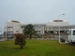
Transport
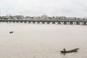
.jpg.webp)
The Autonomous Port of Cotonou is one of the largest in West Africa. The city is connected to Parakou in the north by the Benin-Niger railway. Cotonou International Airport provides service to the capitals of the region and to France, as well as the major cities of Benin: Parakou, Kandi, Natitingou, Djougou, and Savé. There are road connections to neighboring countries: Nigeria, Burkina Faso, Niger, and Togo. A prevalent mode of transport in the city is the motorcycle-taxi, known locally as zémidjan.[4]
In 2015 a suburban passenger railway line was being developed between Cotonou and Pahou.[12]
Economy
Important manufactured goods include palm oil, brewing, textiles, and cement.[13] Motor vehicles and bicycles are assembled, and there are sawmills in the city. Petroleum products, bauxite, and iron are major exports. There are offshore platforms drilling for oil. The city is a centre for the automotive trade, with European brands being sold from vast open-air parking lots. In the past, Citroën assembled cars (for instance, the Citroën 2CV and Ami 8) locally.[14]
By 2012, piracy in the Gulf of Guinea had significantly decreased trade at the port of Cotonou.[15]
In the Missebo area is a textile market of African prints mainly handled by Indian wholesalers and retailers.
Places of worship
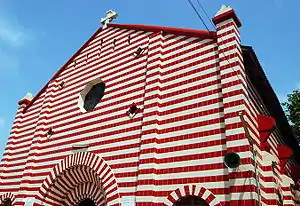
Among the places of worship, Christian churches are predominant: Roman Catholic Archdiocese of Cotonou (Catholic Church), Protestant Methodist Church in Benin (World Methodist Council), Baptist Church of Benin (Baptist World Alliance), Living Faith Church Worldwide, Redeemed Christian Church of God, Assemblies of God.[16] There are also Muslim mosques.
Education
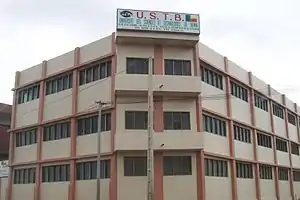
The city has a campus of the University of Science and Technology of Benin (Université des sciences et technologies du Bénin) and a campus of the African University of Technology and Management (Université africaine de technologie et de management). Cotonou is a home to African University Institute Foundation (AUi Foundation) one of the biggest educational philanthropic foundations in Africa, It also hosts some of the most prestigious private universities in Africa which includes, African University of Benin(AUB), Ecole Superieure de Gestion de Technologie (ESGT UNIVERSITY BENIN), Ecole Supérieure D’Administration, D’Economie, De Journalisme Et Des Métiers De L’Audiovisuel (ESAE UNIVERSITY BENIN), Institut Superieur de Communication d’Organisation et de Management, Iscom University Benin.
Media
The Office de Radiodiffusion et Télévision du Bénin (ORTB) — the national television and radio operator — is based in Cotonou.
Sister cities and twin towns
| Country | City | State / Region | Since |
|---|---|---|---|
| 1995 | |||
| 1987 | |||
| 1967 |
References
- https://www.populationdata.net/pays/benin/
- Spelt Kotonu in Chisholm, Hugh, ed. (1911). . Encyclopædia Britannica. 1 (11th ed.). Cambridge University Press. p. 67.
- GNS: Country Files Archived May 4, 2012, at the Wayback Machine. Earth-info.nga.mil. Retrieved on 2011-06-15.
- Butler, Stuart (2019) Bradt Travel Guide - Benin, pgs. 74-91
- Mathurin C. Houngnikpo, Samuel Decalo, Historical Dictionary of Benin, Rowman & Littlefield, USA, 2013, p. 117
- IRIN Humanitarian News. BENIN: Coastal erosion threatening to wipe out parts of Cotonou. Archived 2015-12-08 at the Wayback Machine
- "Benin's Cotonou – a city slowly swallowed by waves" Archived 2019-05-16 at the Wayback Machine, The Terra Daily, 25 January 2008
- "Cotonou, Benin Climate Normals 1961-1990". National Oceanic and Atmospheric Administration. Retrieved December 19, 2018.
- "Klimatafel von Cotonou, Prov. Atlantique (Süd) / Benin" (PDF). Baseline climate means (1961-1990) from stations all over the world (in German). Deutscher Wetterdienst. Archived (PDF) from the original on 24 February 2020. Retrieved 11 June 2016.
- "Station Cotonou" (in French). Meteo Climat. Archived from the original on 5 March 2020. Retrieved 11 June 2016.
- "Languages of Benin". Ethnologue. Archived from the original on 24 May 2019. Retrieved 26 November 2019.
- "Benirail concession: Bolloré Group starts rehabilitation work on the Cotonou-Parakou rail link". Bolloré Africa Logistics. 2 June 2015. Archived from the original on 2015-09-23. Retrieved 2015-09-13.
- Britannica, Cotonou Archived 2016-04-22 at the Wayback Machine, britannica.com, USA, accessed on July 7, 2019
- World Cars 1972. Automobile Club of Italy/Herald Books, New York: 1972. p. 403, ISBN 0-910714-04-5
- "UN says piracy off Africa's west coast is increasing, becoming more violent". The Washington Post. Associated Press. 2012-02-27. Retrieved 2012-02-29.
- J. Gordon Melton, Martin Baumann, ‘‘Religions of the World: A Comprehensive Encyclopedia of Beliefs and Practices’’, ABC-CLIO, USA, 2010, p. 338
External links
| Wikimedia Commons has media related to Cotonou. |