Cramahe
Cramahe is a rural township located in Northumberland County in central Ontario, Canada. It is situated just off Ontario Highway 401 approximately 140 km East of Toronto. It was named for Hector Theophilus de Cramahé, who was Lieutenant-Governor of the Province of Quebec. The seat of the Township and largest town is Colborne.
Cramahe | |
|---|---|
| Township of Cramahe | |
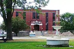 Township hall in Colborne | |
| Motto(s): It's In Our Nature | |
 Cramahe | |
| Coordinates: 44°05′N 77°53′W | |
| Country | |
| Province | |
| County | Northumberland |
| Established | 1850 |
| Government | |
| • Mayor | Mandy Martin |
| • Federal riding | Northumberland—Quinte West |
| • Prov. riding | Northumberland—Quinte West |
| Area | |
| • Land | 202.16 km2 (78.05 sq mi) |
| Population (2016)[1] | |
| • Total | 6,355 |
| • Density | 31.4/km2 (81/sq mi) |
| Time zone | UTC-5 (EST) |
| • Summer (DST) | UTC-4 (EDT) |
| Postal code | K0K 1S0 |
| Area code(s) | 905 |
| Website | www.visitcramahe.ca |
Joseph Keeler opened a store on the site of present-day Colborne about 1819. A community began to grow as other small businessmen followed suit. With the opening of harbour facilities in the 1840s and the arrival of the railway in the 1940, Colborne became an important service centre for the region.[2] Cramahe was incorporated as a township in 1850. In 1858, the village of Colborne seceded from the municipality as a separate township. In 2001, the two municipalities were re-amalgamated to form an expanded Township of Cramahe.
Communities
The township of Cramahe comprises a number of communitie, including the following communities such as Castleton, Colborne, Dundonald, East Colborne, Edville, Greenleys Corners, Griffis Corners, Loughbreeze, Morganston, Purdy Corners, Salem, Shiloh, Tubbs Corners, Victoria Park; Banford Station, Browns Corners, Ogden Point, Spencer Point, Victoria Beach
Colborne
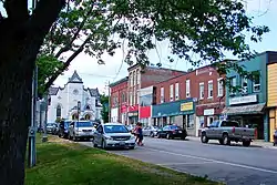
Originally named Keeler's Creek, Colborne (44°00′20″N 77°53′20″W) is the largest and main population centre of the township. It was named after Sir John Colborne, Lieutenant Governor of Upper Canada, by Joseph Abbott Keeler in 1829. Colborne was incorporated as a village in 1858 with a population of approximately 700 people. In 2001, Colborne and Cramahe Township were amalgamated as part of municipal restructuring to form an expanded Township of Cramahe. At the time of dissolution, Colborne Village had a population of 2,040 over an area of 5.2 square kilometres (2.0 sq mi).
Colborne is the home of the Big Apple, a tourist attraction located along Ontario Highway 401. With a height of 10.7 metres (35 ft) and diameter of 11.6 metres (38 ft), the Big Apple is billed as the largest apple in the world. There is an observation deck on top of the apple, a restaurant and other amenities on the premises.[3]
Demographics
| Canada census – Cramahe community profile | |||
|---|---|---|---|
| 2016 | 2011 | ||
| Population: | 6,355 (+4.6% from 2011) | 6,073 (+2.1% from 2006) | |
| Land area: | 202.16 km2 (78.05 sq mi) | 201.98 km2 (77.98 sq mi) | |
| Population density: | 31.4/km2 (81/sq mi) | 30.1/km2 (78/sq mi) | |
| Median age: | 48.4 (M: 47.9, F: 48.9) | ||
| Total private dwellings: | 2,780 | 2,676 | |
| Median household income: | $70,505 | ||
| References: 2016[4] 2011[5] earlier[6] | |||
According to the Canada 2011 Census:[7]
- Mother tongue:
- English as first language: 92.4%
- French as first language: 0.9%
- English and French as first language: 0.2%
- Other as first language: 6.5%
| Year | Pop. | ±% |
|---|---|---|
| 1996 | 5,474 | — |
| 2001 | 5,713 | +4.4% |
| 2006 | 5,950 | +4.1% |
| 2011 | 6,073 | +2.1% |
| 2016 | 6,355 | +4.6% |
| [8][7][1] | ||
Prior to amalgamation (2001):
- Population total in 1996: 5,474
- Cramahe (township): 3,420
- Colborne (village): 2,054
- Population in 1991:
- Cramahe (township): 3,108
- Colborne (village): 2,001
Notable people
- Marcus A. Kemp - Colborne born member of the Wisconsin State Senate
- Charles Smith Rutherford - Colborne born recipient of the Victoria Cross for actions at the Battle of the Scarpe during the First World War
- William Arthur Steel
- Ed Greenwood
See also
References
- "Census Profile, 2016 Census: Cramahe, Township". Statistics Canada. Retrieved June 25, 2019.
- "Archived copy". Archived from the original on 2012-04-03. Retrieved 2011-03-10.CS1 maint: archived copy as title (link) Founding of Colborne
- "The Big Apple". Retrieved June 25, 2019.
- "2016 Community Profiles". 2016 Canadian Census. Statistics Canada. February 21, 2017. Retrieved 2019-06-25.
- "2011 Community Profiles". 2011 Canadian Census. Statistics Canada. July 5, 2013.
- "2001 Community Profiles". 2001 Canadian Census. Statistics Canada. February 17, 2012.
- "Cramahe census profile". 2011 Census of Population. Statistics Canada. Retrieved 2012-03-13.
- Statistics Canada: 1996, 2001, 2006 Census
External links
Places adjacent to Cramahe | |
|---|---|
