Cross Roads, Pennsylvania
Cross Roads is a borough in York County, Pennsylvania, United States. The population was 512 at the 2010 census.[3] The cross roads in the borough is where Church Road (SR 2050) intersects Cross Roads Avenue (SR 2079) and are joined by Century Farms Road. East of the intersection Century Farms Road is numbered SR 2050 and Church Road is unnumbered.
Cross Roads, Pennsylvania | |
|---|---|
Borough | |
 Sign at intersection in Cross Roads | |
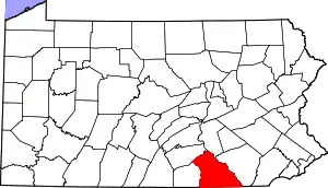
 Location in York County and the U.S. state of Pennsylvania. | |
 Cross Roads Location of Cross Roads in Pennsylvania  Cross Roads Cross Roads (the United States) | |
| Coordinates: 39°48′53″N 76°34′23″W | |
| Country | United States |
| State | Pennsylvania |
| County | York |
| Settled | 1844 |
| Incorporated | 1899 |
| Government | |
| • Type | Borough Council |
| Area | |
| • Total | 1.82 sq mi (4.71 km2) |
| • Land | 1.82 sq mi (4.71 km2) |
| • Water | 0.00 sq mi (0.00 km2) |
| Elevation | 764 ft (233 m) |
| Population (2010) | |
| • Total | 512 |
| • Estimate (2019)[2] | 505 |
| • Density | 277.78/sq mi (107.28/km2) |
| Time zone | UTC-5 (Eastern (EST)) |
| • Summer (DST) | UTC-4 (EDT) |
| ZIP code | 17322 |
| Area code(s) | 717 |
| FIPS code | 42-17416 |
Geography
Cross Roads is located at 39°48′53″N 76°34′23″W (39.814737, -76.573146).[4]
According to the United States Census Bureau, the borough has a total area of 1.9 square miles (4.9 km2), all of it land.
Demographics
| Historical population | |||
|---|---|---|---|
| Census | Pop. | %± | |
| 1880 | 47 | — | |
| 1900 | 167 | — | |
| 1910 | 158 | −5.4% | |
| 1920 | 144 | −8.9% | |
| 1930 | 153 | 6.3% | |
| 1940 | 175 | 14.4% | |
| 1950 | 178 | 1.7% | |
| 1960 | 166 | −6.7% | |
| 1970 | 163 | −1.8% | |
| 1980 | 267 | 63.8% | |
| 1990 | 322 | 20.6% | |
| 2000 | 518 | 60.9% | |
| 2010 | 512 | −1.2% | |
| 2019 (est.) | 505 | [2] | −1.4% |
| Sources:[5][6][7] | |||
As of the census[6] of 2000, there were 518 people, 175 households, and 149 families living in the borough. The population density was 275.5 people per square mile (106.4/km2). There were 185 housing units at an average density of 98.4 per square mile (38.0/km2). The racial makeup of the borough was 96.14% White, 2.90% African American, 0.19% Asian, and 0.77% from two or more races. Hispanic or Latino of any race were 0.39% of the population.
There were 175 households, out of which 44.0% had children under the age of 18 living with them, 77.7% were married couples living together, 5.1% had a female householder with no husband present, and 14.3% were non-families. 10.3% of all households were made up of individuals, and 4.0% had someone living alone who was 65 years of age or older. The average household size was 2.96 and the average family size was 3.19.
In the borough the population was spread out, with 31.1% under the age of 18, 6.4% from 18 to 24, 33.6% from 25 to 44, 23.0% from 45 to 64, and 6.0% who were 65 years of age or older. The median age was 34 years. For every 100 females there were 97.0 males. For every 100 females age 18 and over, there were 96.2 males.
The median income for a household in the borough was $57,750, and the median income for a family was $60,556. Males had a median income of $40,000 versus $31,875 for females. The per capita income for the borough was $20,063. About 2.5% of families and 3.0% of the population were below the poverty line, including 3.4% of those under age 18 and none of those age 65 or over.
Education
Cross Roads Borough is served by the South Eastern School District which provides public education.
References
- "2019 U.S. Gazetteer Files". United States Census Bureau. Retrieved July 28, 2020.
- "Population and Housing Unit Estimates". United States Census Bureau. May 24, 2020. Retrieved May 27, 2020.
- "Race, Hispanic or Latino, Age, and Housing Occupancy: 2010 Census Redistricting Data (Public Law 94-171) Summary File (QT-PL), Cross Roads borough, Pennsylvania". United States Census Bureau. Retrieved October 4, 2011.
- "US Gazetteer files: 2010, 2000, and 1990". United States Census Bureau. 2011-02-12. Retrieved 2011-04-23.
- "Census of Population and Housing". U.S. Census Bureau. Retrieved 11 December 2013.
- "U.S. Census website". United States Census Bureau. Retrieved 2008-01-31.
- "Incorporated Places and Minor Civil Divisions Datasets: Subcounty Resident Population Estimates: April 1, 2010 to July 1, 2012". Population Estimates. U.S. Census Bureau. Archived from the original on June 11, 2013. Retrieved 11 December 2013.
| Authority control |
|
|---|