Csongrád-Csanád County
Csongrád-Csanád (Hungarian: Csongrád-Csanád megye [ˈt͡ʃoŋɡraːd ˈt͡ʃɒnaːd]) is the name of an administrative county (comitatus or megye) in southern Hungary, straddling the river Tisza, on the border with Serbia and Romania. It shares borders with the Hungarian counties Bács-Kiskun County, Jász-Nagykun-Szolnok County and Békés. The administrative centre of Csongrád-Csanád county is Szeged. The county is also part of the Danube–Criș–Mureș–Tisa Euroregion euroregion.
Csongrád-Csanád County
Csongrád-Csanád megye | |
|---|---|
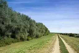  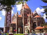 Descending, from top: Maros river embankment near Makó, Ópusztaszer National Heritage Park, and Cathedral of Szeged | |
 Flag  Coat of arms | |
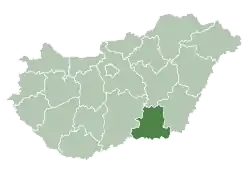 Csongrád-Csanád County within Hungary | |
| Country | |
| Region | Southern Great Plain |
| County seat | Szeged |
| Districts | |
| Government | |
| • President of the General Assembly | Béla Kakas (Fidesz-KDNP) |
| Area | |
| • Total | 4,262.71 km2 (1,645.84 sq mi) |
| Area rank | 12th in Hungary |
| Population (2015) | |
| • Total | 406,205[1] |
| • Rank | 8th in Hungary |
| Postal code | 66xx – 69xx |
| Area code(s) | (+36) 62, 63 |
| ISO 3166 code | HU-CS |
| Website | www |
History
On October 3, 2017, the Hungarian Parliament passed a resolution to rename Csongrád County to Csongrád-Csanád County, which took effect on June 4, 2020.[2] The resolution was submitted by János Lázár, then-Minister of the Prime Minister's Office, who called the renaming symbolic as more than a dozen settlements in the area still share Csanád County's identity.[3]
Geography
This county has a total area of 4,263 km2 (1,646 sq mi) – 4,58% of Hungary.
The area of Csongrád-Csanád County is flat. It has a high number of sunshine hours and excellent soil, which makes it the most important agricultural area of Hungary. Its most famous products are paprika from Szeged and onions from Makó, but grain, vegetables, and fruits are also significant. Half of the onions, paprika, and vegetables produced in Hungary are from Csongrád-Csanád. The county is also rich in oil and natural gas.
The highest point is Ásotthalom (125 m), the lowest is Gyálarét (78 m; lowest point of Hungary).
Neighbours
- Jász-Nagykun-Szolnok County in the North.
- Békés County in the East.
 Romania and
  Serbia in the South – Timiș County, Arad County, North Banat District and North Bačka District
- Bács-Kiskun County in the West.
Demographics
Religion in Csongrád-Csanád County (2011 census)
After the end of the Ottoman occupation in 1715, the county was nearly uninhabited, with a population density of less than 5/km2. In the 18th and 19th centuries, the county was repopulated by ethnic Hungarians from the relatively overpopulated northern and western counties of the Kingdom of Hungary.[4] According to the 2001 census, the county is home for 423,826 people (216,936 people live in urban counties) with a population density is 100/km2. It has a Hungarian majority.[5]
In 2015, it had a population of 406,205 and the population density was 95/km².
| Year | County population[6] | Change |
|---|---|---|
| 1949 | 429,083 | n/a |
| 1960 | 1.16% | |
| 1970 | 2.57% | |
| 1980 | 2.49% | |
| 1990 | -3.83% | |
| 2001 | -1.25% | |
| 2011 | -3.67% |
Ethnicity
Besides the Hungarian majority, the main minorities are the Roma (approx. 5,000), Romanian (1,500), German (1,300) and Serb (1,300).
Total population (2011 census): 417,456
Ethnic groups (2011 census):[7]
Identified themselves: 367,193 persons:
- Hungarians: 355,554 (96.83%)
- Gypsies: 4,720 (1.29%)
- Others and indefinable: 6,919 (1.88%)
Approximately 59,000 persons in Csongrád-Csanád County did not declare their ethnic group on the 2011 census.
Religion
Religious adherence in the county according to the 2011 census:[8]
- Catholic – 165,955 (Roman Catholic – 164,060; Greek Catholic – 1,855);
- Reformed – 29,289;
- Evangelical – 3,488;
- Orthodox – 923;
- Judaism – 263;
- Other religions – 7,278;
- Non-religious – 90,836;
- Atheism – 6,585;
- Undeclared – 112,839.
Regional structure
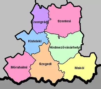
| № | English and Hungarian names |
Area (km²) |
Population (2011) |
Density (pop./km²) |
Seat | № of municipalities |
| 1 | Csongrád District Csongrádi járás |
339.24 | 22,996 | 68 | Csongrád (town) | 4 |
| 2 | Hódmezővásárhely District Hódmezővásárhelyi járás |
707.77 | 56,560 | 80 | Hódmezővásárhely | 4 |
| 3 | Kistelek District Kisteleki járás |
410.20 | 18,185 | 44 | Kistelek | 6 |
| 4 | Makó District Makói járás |
688.85 | 45,138 | 66 | Makó | 15 |
| 5 | Mórahalom District Mórahalmi járás |
561.71 | 28,986 | 52 | Mórahalom | 10 |
| 6 | Szeged District Szegedi járás |
741.10 | 204,263 | 276 | Szeged | 13 |
| 7 | Szentes District Szentesi járás |
813.84 | 41,328 | 51 | Szentes | 8 |
| Csongrád-Csanád County | 4,262.71 | 417,456 | 98 | Szeged | 60 | |
|---|---|---|---|---|---|---|
Transport
Road network
In 2012, Csongrád-Csanád County had a dense network of public roads, in total length of 1,350 km, of which 281 km were main roads.[9] Inland, connections were provided by 1,049 km of county and communal roads and 20 km were covered with light road surfaces.
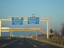
- Highway network
_Otszogletu_kek_tabla.svg.png.webp)
 runs from Budapest to Röszke (Serbian border). ~ 47 km
_Otszogletu_kek_tabla.svg.png.webp) runs from Szombathely to Szeged. (planned)
runs from Szombathely to Szeged. (planned)_Otszogletu_kek_tabla.svg.png.webp)
 runs from Szeged to Csanádpalota (Romanian border). - 58 km
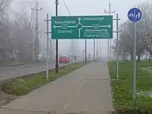
- Road network
_Otszogletu_zold_tabla.svg.png.webp) runs from Budapest to Röszke (Serbian border), via Kistelek and Szeged. - 52 km
runs from Budapest to Röszke (Serbian border), via Kistelek and Szeged. - 52 km_Otszogletu_zold_tabla.svg.png.webp) runs from Szeged to Nagylak, via Makó. - 55 km
runs from Szeged to Nagylak, via Makó. - 55 km- 430 runs from Makó to Hódmezővásárhely. - 30 km
_Otszogletu_zold_tabla.svg.png.webp) runs from Makó to Kiszombor (Romanian border). - 6 km
runs from Makó to Kiszombor (Romanian border). - 6 km_Otszogletu_zold_tabla.svg.png.webp) runs from Kunszentmárton to Hódmezővásárhely, via Szentes. - 43 km
runs from Kunszentmárton to Hódmezővásárhely, via Szentes. - 43 km_Otszogletu_zold_tabla.svg.png.webp) runs from Szeged to Debrecen, via Hódmezővásárhely.
runs from Szeged to Debrecen, via Hódmezővásárhely._Otszogletu_zold_tabla.svg.png.webp) runs from Szeged to Bátaszék, via Mórahalom.
runs from Szeged to Bátaszék, via Mórahalom._Otszogletu_zold_tabla.svg.png.webp) runs from Kiskunfélegyháza to Szentes, via Csongrád.
runs from Kiskunfélegyháza to Szentes, via Csongrád._Otszogletu_zold_tabla.svg.png.webp) western bypass of Szeged.
western bypass of Szeged.
Politics
The Csongrád-Csanád County Council, elected at the 2019 local government elections, is made up of 20 counselors,[10] with the following party composition:
| Party | Seats | Current County Assembly | ||||||||||||
|---|---|---|---|---|---|---|---|---|---|---|---|---|---|---|
| Fidesz-KDNP | 12 | |||||||||||||
| Hungarian Socialist Party | 2 | |||||||||||||
| Jobbik | 2 | |||||||||||||
| Our Homeland Movement | 2 | |||||||||||||
| Democratic Coalition | 1 | |||||||||||||
| Momentum Movement | 1 | |||||||||||||
Presidents of the General Assembly
| List of Presidents, from 1990[11] | |
|---|---|
| István Lehmann (MSZP) | 1990–1998 |
| Dr. József Frank (Fidesz) | 1998–2006 |
| Anna Magyar (Fidesz-KDNP) | 2006–2014 |
| Béla Kakas (Fidesz-KDNP) | 2014– |
Municipalities
Csongrád-Csanád County has 2 urban counties, 8 towns, 7 large villages and 43 villages.
As a typical Great Plain county, Csongrád-Csanád has a relatively small number of municipalities. 72.5% of the population lives in cities/towns, so it is one of the most urbanized county in Hungary.[12]
- Cities with county rights
(ordered by population, as of 2011 census)
- Szeged (168,048) – county seat
- Hódmezővásárhely (46,047)
- Towns
- Szentes (28,509)
- Makó (23,683)
- Csongrád (17,242)
- Sándorfalva (7,871)
- Kistelek (7,103)
- Mindszent (6,914)
- Mórahalom (5,804)
- Csanádpalota (2,923)
- Villages
- Algyő

- Ambrózfalva
- Apátfalva
- Árpádhalom
- Ásotthalom
- Baks
- Balástya
- Bordány
- Csanádalberti
- Csanytelek
- Csengele
- Derekegyház
- Deszk
- Domaszék
- Dóc
- Eperjes
- Fábiánsebestyén
- Felgyő
- Ferencszállás
- Forráskút
- Földeák
- Királyhegyes
- Kiszombor
- Klárafalva
- Kövegy
- Kübekháza
- Magyarcsanád
- Maroslele
- Mártély
- Nagyér
- Nagylak
- Nagymágocs
- Nagytőke
- Óföldeák
- Ópusztaszer
- Öttömös
- Pitvaros
- Pusztamérges
- Pusztaszer
- Röszke
- Ruzsa
- Szatymaz
- Szegvár
- Székkutas
- Tiszasziget
- Tömörkény
- Újszentiván
- Üllés
- Zákányszék
- Zsombó
![]() municipalities are large villages.
municipalities are large villages.
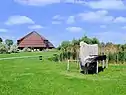
Gallery
_19.jpg.webp) Szeged, the capital of the county
Szeged, the capital of the county_45.jpg.webp) County hall in Szentes
County hall in Szentes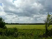 Great Hungarian Plain in Csongrád-Csanád County
_3.jpg.webp) Windmill near Szeged
Windmill near Szeged_2.jpg.webp) Károlyi Mansion in Nagymágocs
Károlyi Mansion in Nagymágocs_4.jpg.webp) Traditional house in Csongrád
Traditional house in Csongrád.jpg.webp) River Kurca
River Kurca Church of Forests in Ópusztaszer
References
| Wikimedia Commons has media related to Csongrád-Csanád County. |
| Wikivoyage has a travel guide for Csongrád County. |
- nepesseg.com, population data of Hungarians settlements
- Harmat Árpád, Péter (October 5, 2017). "Csongrád - Csanád megye, az új elnevezés védelmében". Retrieved April 4, 2020.
- "Új neve van Csongrád megyének". HVG. October 3, 2017. Retrieved April 7, 2020.
- Changing ethnicities in Hungary (map+data+assay) (Károly Kocsis, Zsolt Bottlik, MTA Földrajztudományi Kutatóintézet, Budapest 2009, ISBN 978-963-9545-18-2, ISBN 978-963-9545-19-9)
- Csongrád county (2001 census), English
- népesség.com, "Csongrád megye népessége 1870-2015"
- 1.1.6. A népesség anyanyelv, nemzetiség és nemek szerint – Frissítve: 2013.04.17.; Hungarian Central Statistical Office (in Hungarian)
- 2011. ÉVI NÉPSZÁMLÁLÁS, 3. Területi adatok, 3.6 Csongrád megye, (in Hungarian) Archived 2017-01-13 at the Wayback Machine
- "Csongrád Megyei Terület fejlesztési Koncepció" (PDF) (in Hungarian). Cite journal requires
|journal=(help) - "Megyei közgyűlés tagjai 2019-2024 (Csongrád megye)". valasztas.hu. Retrieved 2019-10-29.
- Önkormányzati választások eredményei (in Hungarian)
- List of localities in Csongrád county by area, population and status (2001 census), English
External links
| Cities with county rights |
| |
|---|---|---|
| Towns | ||
| Large villages | ||
| Villages |
| |
| Other topics |
| |