Timiș County
Timiș (Romanian pronunciation: [ˈtimiʃ]) is a county (județ) of western Romania on the border with Hungary and Serbia, in the historical region Banat, with the county seat at Timișoara. It is the westernmost and the largest county in Romania in terms of land area. The county is also part of the Danube–Criș–Mureș–Tisa Euroregion.
Timiș County
Județul Timiș | |
|---|---|
County | |
 Coat of arms | |
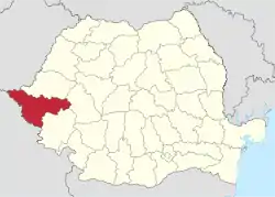 Timiș county, territorial location | |
| Coordinates: 45.78°N 21.35°E | |
| Country | |
| Development region | Vest |
| Historical region | Banat |
| County seat | Timișoara |
| Government | |
| • Type | County Council |
| • President of the County Council | Alin-Adrian Nica (PNL) |
| • Prefect | Liliana Oneț[1] |
| Area | |
| • Total | 8,697 km2 (3,358 sq mi) |
| Area rank | 1st |
| Population (2011 census[2]) | |
| • Total | 683,540 |
| • Rank | 6th |
| • Density | 78/km2 (200/sq mi) |
| Time zone | UTC+2 (EET) |
| • Summer (DST) | UTC+3 (EEST) |
| Area code(s) | (+40) 256 or (+40) 356 |
| ISO 3166 code | RO-TM |
| Car Plates | TM |
| GDP (nominal) | US$ 11.230 billion (2018) |
| GDP per capita | US$ 16,430 (2018) |
| Economy rank | 2nd |
| Website | County Council County Prefecture |
Name
The name of the county comes from the river Timiș, known in Roman antiquity as river Tibisis or Tibiscus.
In Hungarian, it is known as Temes megye, German as Kreis Temesch, in Serbian as Тамиш / Tamiš, in Ukrainian as Ті́міш, and in Banat Bulgarian as Timiš.
Demographics
In 2000, the county had a population of 684,506 and the population density was 79/km2. According to the 2011 census, the county had a population of 683,540 and the population density was 78/km2. The reported ethnic groups were as follows:[3]
- Romanians - 85.52%
- Hungarians - 5.43%
- Roma - 2.23%
- Germans (Banat Swabians) - 1.3%
- Serbs - 2%
- Ukrainians - 0.91%
- Bulgarians - 0.8%
- Others - 0.7%
| Year | County population[4] |
|---|---|
| 1948 | 588,936 |
| 1956 | |
| 1966 | |
| 1977 | |
| 1992 | |
| 2002 | |
| 2011 |
Geography
This county has a total area of 8,697 km2 (3,6% of Romania). It is the largest county in Romania.
In the eastern extremity are the Poiana Ruscă Mountains from the Western Romanian Carpathians group. Elevations decrease to the west, passing through the Lipova Hills to the Western Romanian Plain, the eastern part of the Pannonian Plain.
The county is crossed by many rivers, the most important being the Bega and the Timiș.
Neighbours
- Hunedoara County to the east.
- Hungary to the northwest - Csongrád County.
- Arad County to the north.
- Caraș-Severin County to the south.
- Serbia to the southwest - Vojvodina Autonomous Province - North Banat District, Central Banat District and South Banat District
Economy
Timiș County has one of the most dynamic economies in Romania. Timiș County has a gross domestic product (GDP) for 2020 of 50.27 billion lei, surpassed only by Bucharest (245 billion) according to the National Commission for Strategy and Forecast, contributing over 5% of Romania's total GDP, having a high-developed economy and one of the highest purchasing power in the country, being the region with the highest ratings of foreign investment (after Bucharest - 4.5 billion in 2020), due to its tradition and its position. At the end of 2020, Timiș County had, according to the National Institute of Statistics, a Gross Domestic Product per capita of 15,870 euros, 30% over the national average, and an annual growth rate of 5-10%.
The predominant industries in the county are:
- IT&C and computer programming - (Microsoft, Intel, IBM, Nokia, Huawei, Atos), etc.;
- Engineering and mechanical manufacturing - (Continental AG, Dräxlmaier Group, TRW), etc.;
- Electronic components manufacturing - (Flextronics, Hella, Dura), etc.;
- Chemicals - (Linde Gas, Procter & Gamble), etc.;
- Food and beverages - (Comtim, Timișoreana, Nestlé, Coca-Cola), etc.;
- Retail and consumer services - headquarters of (Profi, DM), etc.;
Infrastructure
Timiș County is crossed by important European roads and the Pan-European transport corridor IV, both road and rail, due to its connection to the Trans-European Transport Network.
The county is a major road junction in international transit traffic, being located on the pan-European corridor Dresden-Constanța (which connects Central Europe to the Black Sea), as well as the node of the future trans-European route Via Carpatia (which in Europe connects the ports of Klaipėda on the Baltic Sea and Thessaloniki on the Aegean Sea). The county is crossed by the A1 highway, part of the Pan-European transport corridor IV, a segment that continues with the M43 motorway, to Szeged, providing a direct road connection with Western Europe and to the continental highway network. The A1 is connected to Lugoj with the A6 highway, which is under construction. The first section of the highway, 11 km, between Balinț and Lugoj, where there is a road junction with the European route E70, was inaugurated on December 19, 2013.
Tourism


Timiș has a very rich offer in terms of tourism and leisure activities, being constantly in the top of destinations chosen by foreign tourists visiting Romania. In 2017 it was the third most visited county in Romania, after Bucharest-Ilfov and Brașov, in terms of the number of foreign tourists. The main tourist attractions in the county are:
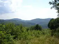
- The Poiana Ruscă Mountains, in the easternmost part of the county;
- The Surduc Lake area;
- Dacian fortresses of Herneacova and Unip;
- Timișoara: Timișoara has the largest architectural ensemble of historical buildings in Romania (approx. 14,500), consisting of the urban heritage of the Cetate, Iosefin, Fabric and Elisabetin neighborhoods and is the European Capital of Culture for 2023. Among the few main attractions are the Timișoara Fortress, Theresia Bastion, Huniade Castle, Romanian National Opera, Banatul State Philharmonic Orchestra, Museum of Banat, Timișoara Orthodox Cathedral, the Fabric Synagogue, St. George's Dome, Virgin Mary Monument etc.;
- Lugoj: Dormition of the Theotokos Church;
- Buziaș Resort;
- Castles at Banloc and Carani;
- Șag and Săraca monasteries;
- Satchinez swamps, an ornithological reservation near the village of Satchinez;
- Charlottenburg, the only round village(Rundling) in the Banat region;
There are also a lot of places for hunting and fishing.
Politics
The Timiș County Council, elected at the 2016 local government elections, is made up of 37 counselors, with the following party composition:[5]
| Party | Seats | Current County Council | ||||||||||||||||
|---|---|---|---|---|---|---|---|---|---|---|---|---|---|---|---|---|---|---|
| Social Democratic Party | 16 | |||||||||||||||||
| National Liberal Party | 14 | |||||||||||||||||
| People's Movement Party | 5 | |||||||||||||||||
| Alliance of Liberals and Democrats | 2 | |||||||||||||||||
People
- Ana Blandiana, poet;
- Yohan Kende, Israeli Olympic swimmer;
- Béla Lugosi, Hungarian-American actor;
- Lavinia Miloșovici, gymnast;
- Traian Vuia, engineer, inventor of the monoplane and aviation pioneer;
- Johnny Weissmüller, double gold Olympic swimmer, main actor of Tarzan;
- Nicu Covaci, Romanian rock musician, singer, guitar player and composer, founder of Phoenix rock band;
- Tiberiu Brediceanu, composer;
- Iosif Constantin Drăgan, Romanian businessman, entrepreneur and philanthropist;
- Béla Bartók, Hungarian composer;
- Elek Schwartz, Romanian footballer and coach of the Dutch national football team;
- Edina Gallovits-Hall, Romanian-born American professional tennis player;
- Dositej Obradović, Serbian writer and translator;
- Dan Negru, TV presenter and host of the Romanian version of Star Factory show;
- Ioan Holender, Romanian-Austrian opera baritone and former director of the Vienna State Opera;
- Nikolaus Lenau, Austrian poet;
- Herta Müller, German novelist, writer, poet and essayist, Nobel Literature Prize laureate;
- Francesco Illy, Hungarian accountant, bookkeeper, businessman, philanthropist, inventor of the espresso machine and founder of Illy Coffee brand;
- Ion Ivanovici, Serbian composer, best known for his waltz Waves of the Danube;
- Károly Kerényi, Hungarian philologist;
- J. Edward Bromberg, Hungarian-American actor.
Administrative divisions

Timiș County has 2 municipalities, 8 towns and 89 communes
- Municipalities
- Towns
- Sânnicolau Mare - population: 11,540 (as of 2011)
- Jimbolia - population: 10.808 (as of 2011)
- Recaș - population: 7,782 (as of 2011)
- Făget - population: 6,571 (as of 2011)
- Buziaș - population: 6,504 (as of 2011)
- Deta - population: 5,963 (as of 2011)
- Gătaia - population: 5,449 (as of 2011)
- Ciacova - population: 5,348 (as of 2011)
- Communes
- Balinț
- Banloc
- Bara
- Bârna
- Beba Veche
- Becicherecu Mic
- Belinț
- Bethausen
- Biled
- Birda
- Bogda
- Boldur
- Brestovăț
- Bucovăț
- Cărpiniș
- Cenad
- Cenei
- Checea
- Chevereșu Mare
- Comloșu Mare
- Coșteiu
- Criciova
- Curtea
- Darova
- Denta
- Dudeștii Noi
- Dudeștii Vechi
- Dumbrava
- Dumbrăvița
- Fârdea
- Fibiș
- Foeni
- Gavojdia
- Ghilad
- Ghiroda
- Ghizela
- Giarmata
- Giera
- Giroc
- Giulvăz
- Gottlob
- Iecea Mare
- Jamu Mare
- Jebel
- Lenauheim
- Liebling
- Livezile
- Lovrin
- Margina
- Mașloc
- Mănăștiur
- Moravița
- Moșnița Nouă
- Nădrag
- Nițchidorf
- Ohaba Lungă
- Orțișoara
- Otelec
- Parța
- Pădureni
- Peciu Nou
- Periam
- Pesac
- Pietroasa
- Pișchia
- Racovița
- Remetea Mare
- Sacoșu Turcesc
- Saravale
- Satchinez
- Săcălaz
- Sânandrei
- Sânmihaiu Român
- Sânpetru Mare
- Secaș
- Șag
- Șandra
- Știuca
- Teremia Mare
- Tomești
- Tomnatic
- Topolovățu Mare
- Tormac
- Traian Vuia
- Uivar
- Variaș
- Vălcani
- Victor Vlad Delamarina
- Voiteg
See also
References
| Wikimedia Commons has media related to Timiș County. |
- office@werbo.ro, Werbo. "Institutia Prefectului judetul Timis". www.prefecturatimis.ro.
- "Population at 20 October 2011" (in Romanian). INSSE. 5 July 2013. Retrieved 9 July 2013.
- National Institute of Statistics, "Populația după etnie" Archived 2009-08-16 at the Wayback Machine
- National Institute of Statistics, "Populația la recensămintele din anii 1948, 1956, 1966, 1977, 1992 și 2002"
- "Mandate de CJ pe judete si competitori" (in Romanian). Biroul Electoral Central. 10 June 2016. Retrieved 16 June 2016.
External links
Google earth file (kmz) with information about the Timis Bega catchment and the 2005 flood event Download the kmz file
| Authority control |
|---|