Dasharathchand
Dasharathchand is a municipality and the district headquarter of Baitadi District in Sudurpashchim Pradesh of Nepal. It is a hill station above Mahakali River close to the Indian border. At the time of the 2011 Nepal census it had a population of 34,575 people living in 7,257 individual households.[1]
Dasharathchand
दशरथचन्द | |
|---|---|
.JPG.webp) Hill station, Dashrathchanda | |
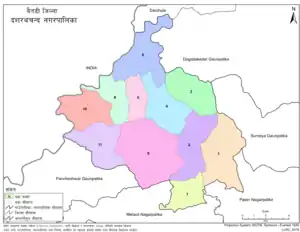 Diviaional map of Dashrathchanda Municipality | |
 Dasharathchand Location of Dasharathchanda in Sudurpashchim  Dasharathchand Dasharathchand (Nepal) | |
| Coordinates: 29°33′17″N 80°25′36″E | |
| Country | Nepal |
| Province | Sudurpashchim Pradesh |
| District | Baitadi District |
| Wards | 11 |
| Established | 1997 |
| Government | |
| • Type | Mayor-council |
| • Mayor | Narendra Singh Thapa (NC) |
| • Deputy Mayor | Mina Chand (NC) |
| Area | |
| • Total | 135.15 km2 (52.18 sq mi) |
| Population (2011) | |
| • Total | 34,575 |
| • Density | 260/km2 (660/sq mi) |
| • Religions | Hindu |
| Time zone | UTC+5:45 (NST) |
| Postal code | 10200 |
| Area code(s) | 095 |
| Website | dasharathchandmun |
Background
Dasharatchand municipality was established in 1997 at the time, when the government of Nepal established a total of 22 Municipalities.[2] Six VDCs were merged while establishing this municipality. Those VDCs were: Dashrathchanda, Khalanga, Tripurasundari, Thalegada, Jogannath and Barakot.[3] According to the 2011 Nepal census it's total population was 17,427 and total area was 55.01 square kilometres (21.24 sq mi). It was divided into 13 wards.[4]
In March 2017, the Government of Nepal restructured the all the local level bodies of Nepal into 753 new local level structures. [5] [6] The previous Gurukhola, Dehimandau, Durga Bhabani, portion of Durgasthan, Gwallek and Nagarjun VDCs merged to the former Dashrathchanda Municipality and rearranged it into 11 wards. Now total population of the Dashrathchanda Municipality is 34,575 individuals and total area is 135.15 square kilometres (52.18 sq mi).[7]
Media
To promote local culture, Dasharathchanda has two FM radio stations – Saugat F.M. (103.6 MHz) and Radio Sunsher (106.6 MHz). There is also Radio Nwedeu, a community radio station.
Transportation
Mahakali Highway links Dasharathchand to Dhangadhi in the South and Api Municipality in the North.[8]
References
- "National Population and Housing Census 2011" (PDF). Central Bureau of Statistics. November 2017. Archived from the original (PDF) on 27 January 2018. Retrieved 1 May 2018.
- "Population Monograph of Nepal Vol-3" (PDF). Central Bureau of Statistics. 2014. Retrieved 3 February 2021.
- "Official website of Dashrathchanda Municipality". Dashrathchanda Municipality. Retrieved 3 February 2021.
- "National Population and Housing Census 2011 (National Report)" (PDF). Central bureau of statistics. Retrieved 3 February 2021.
- "New local level structure comes into effect from today". www.thehimalayantimes.com. The Himalayan Times. 10 March 2017. Retrieved 17 July 2018.
- "New local level units come into existence". www.kathmandupost.ekantipur.com. 11 March 2017. Retrieved 18 July 2018.
- "District Corrected Last for RAJAPATRA" (PDF). www.mofald.gov.np. Retrieved 17 July 2018.
- Nepal Country Study Guide – Strategic Information and Developments. IBP USA. 2012. pp. 197–200.
Headquarters: Dasharathchand | ||
| Municipalities | 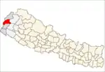 | |
| Rural municipalities | ||
| Former VDCs |
| |
List of municipalities and rural municipalities of Nepal | ||