Degilbo
Degilbo is a town and a locality in the North Burnett Region, Queensland, Australia.[2][3] In the 2016 census, Degilbo had a population of 174 people.[1]
| Degilbo Queensland | |||||||||||||||
|---|---|---|---|---|---|---|---|---|---|---|---|---|---|---|---|
 War memorial | |||||||||||||||
 Degilbo | |||||||||||||||
| Coordinates | 25.4827°S 151.9994°E | ||||||||||||||
| Population | 174 (2016 census)[1] | ||||||||||||||
| • Density | 1.855/km2 (4.804/sq mi) | ||||||||||||||
| Postcode(s) | 4621 | ||||||||||||||
| Area | 93.8 km2 (36.2 sq mi) | ||||||||||||||
| Time zone | AEST (UTC+10:00) | ||||||||||||||
| Location |
| ||||||||||||||
| LGA(s) | North Burnett Region | ||||||||||||||
| State electorate(s) | Callide | ||||||||||||||
| Federal Division(s) | Flynn | ||||||||||||||
| |||||||||||||||
History
The name Degilbo was the name of a pastoral run owned by William Henry Walsh (a Member of the Queensland Legislative Council) in 1847. It is believed to be an Aboriginal word dackeel bo meaning sharp or upright stones.[4] A very popular story is that Degiblo is actually the word obliged spelt backwards, attributed to a railway surveyor, who had to assign names to many railway stations, had run out of ideas but as he was obliged to come up with a name, he wrote that word down backwards.[5] Being perhaps a more entertaining story, the story of the backwards spelling is frequently published, and is usually followed by a spate of correspondence pointing out that the name of the pastoral run preceded the railway station by at least 20 years.[6][7]
The first Degilbo Post Office opened on 1 April 1893. It was renamed Woowoonga in 1894, Appallan in 1897 and Degilbo in 1898. It closed in 1958.[8]
Woowoonga Provisional School opened on 15 March 1894. In 1898 it was renamed Degilbo Provisional School and in January 1908 it became Degilbo State School. It was mothballed in December 2007 before final closure on 5 June 2008.[9]
Woowoonga Creek Provisional School on 17 January 1898 and became Woowoonga Creek State School on 1 January 1909 only to close that same year.[10] The school was just south of Woowoonga Creek at 25.4612°S 152.0448°E.[11][12]
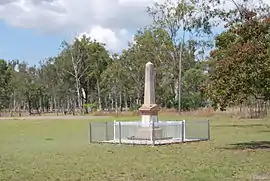
The Degilbo War Memorial commemorates those who served and died in World War I. It is located beside the Isis Highway.[13]
At the 2011 census, Degilbo had a population of 338.[14]
Heritage listings
Degilbo has a number of heritage-listed sites, including:
- 6 kilometres (3.7 mi) west of Degilbo on the Mungar-Monto railway line: Deep Creek Railway Bridge[15][16]
- Exhibition Street: Degilbo Hall[16]
- 607 Seccombes Road, off Maryborough - Biggenden Road: Degilbo Cemetery[16]
Education
There are no schools in Degilbo. The nearest primary schools are in Biggenden and Dallarnil while the nearest secondary schools are in Biggenden (to Year 10) and in Gayndah and Childers (both to Year 12).[17]
References
- Australian Bureau of Statistics (27 June 2017). "Degilbo (SSC)". 2016 Census QuickStats. Retrieved 20 October 2018.

- "Degilbo – town in North Burnett Region (entry 9673)". Queensland Place Names. Queensland Government. Retrieved 30 December 2017.
- "Degilbo – locality in North Burnett Region (entry 45340)". Queensland Place Names. Queensland Government. Retrieved 30 December 2017.
- "Degilbo (entry 9673)". Queensland Place Names. Queensland Government. Retrieved 13 September 2015.
- "Letters to the Editor". The Courier-Mail. Brisbane: National Library of Australia. 30 October 1935. p. 21. Retrieved 12 July 2013.
- "ABORIGINAL NAMES". The Sydney Morning Herald. National Library of Australia. 11 March 1922. p. 15. Retrieved 12 July 2013.
- "MEANING OF DEGILBO". The Brisbane Courier. National Library of Australia. 15 December 1930. p. 3. Retrieved 12 July 2013.
- Premier Postal History. "Post Office List". Premier Postal Auctions. Retrieved 10 May 2014.
- Queensland Family History Society (2010), Queensland schools past and present (Version 1.01 ed.), Queensland Family History Society, ISBN 978-1-921171-26-0
- Queensland Family History Society (2010), Queensland schools past and present (Version 1.01 ed.), Queensland Family History Society, ISBN 978-1-921171-26-0
- "Parish of Woowoonga" (Map). Queensland Government. 1900. Retrieved 10 January 2021.
- "Queensland Globe". State of Queensland. Retrieved 10 January 2021.
- "Degiblo War Memorial". Monument Australia. Retrieved 5 April 2014.
- Australian Bureau of Statistics (31 October 2012). "Degilbo (SSC)". 2011 Census QuickStats. Retrieved 12 July 2013.
- "Deep Creek Railway Bridge, Chowey (entry 600031)". Queensland Heritage Register. Queensland Heritage Council. Retrieved 12 July 2013.
- "North Burnett Local Heritage Register" (PDF). North Burnett Regional Council. Archived (PDF) from the original on 16 August 2019. Retrieved 16 August 2019.
- "Queensland Globe". State of Queensland. Retrieved 31 July 2019.
