Dereel, Victoria
Dereel is a town in the Western District of the Australian state of Victoria. At the 2016 census, Dereel and the surrounding area had a population of 533.[1]
| Dereel Victoria | |||||||||||||||
|---|---|---|---|---|---|---|---|---|---|---|---|---|---|---|---|
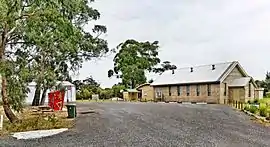 Dereel Soldiers' Memorial Hall and CFA shed, October 2008 | |||||||||||||||
 Dereel | |||||||||||||||
| Coordinates | 37°49′0″S 143°45′0″E | ||||||||||||||
| Population | 533 (2016 census)[1] | ||||||||||||||
| Postcode(s) | 3352 | ||||||||||||||
| Elevation | 348 m (1,142 ft)[2] | ||||||||||||||
| Location | |||||||||||||||
| LGA(s) | Golden Plains Shire | ||||||||||||||
| State electorate(s) | Buninyong | ||||||||||||||
| Federal Division(s) | Wannon | ||||||||||||||
| |||||||||||||||
It is located on the Ballarat-Colac Road, 33 kilometres (21 mi) from Ballarat and 70 kilometres (43 mi) from Colac. There is no clearly defined town centre, though the Dereel Soldiers' Memorial Hall, located on Swamp Road, is commonly considered as the town centre.
Dereel Post Office opened on 1 November 1868 and closed in 1971.[3]
Dereel includes a large wetlands area, referred to as the "Swamp" or "Lagoon". In recent years it is almost dry.
On 27 March 2013, a bushfire at Dereel destroyed 16 houses and 18 sheds. The fire covered 1,300 hectares (3,212 acres).[4]
References
- Australian Bureau of Statistics (27 June 2017). "Dereel (State Suburb)". 2016 Census QuickStats. Retrieved 30 August 2017.

- http://nona.net/features/map/placedetail.1505025/Dereel/ Retrieved on 24 July 2009
- Premier Postal History, Post Office List, retrieved 11 April 2008
- "16 homes confirmed lost in Dereel fire". ABC News. 28 March 2013. Retrieved 28 March 2013.
This article is issued from Wikipedia. The text is licensed under Creative Commons - Attribution - Sharealike. Additional terms may apply for the media files.
