Dinghai District
![]() Dinghai (simplified Chinese: 定海区; traditional Chinese: 定海區; pinyin: Dìnghǎi Qū) is a district of Zhoushan City made of 128 islands in Zhejiang province, China. It is based on the larger northwestern half of Zhoushan Island, where it borders Putuo in the east. The district boundary meets that of Daishan County out at sea to the north of the island. Its southwestern boundary intersects the border of Ningbo, also entirely at sea.
Dinghai (simplified Chinese: 定海区; traditional Chinese: 定海區; pinyin: Dìnghǎi Qū) is a district of Zhoushan City made of 128 islands in Zhejiang province, China. It is based on the larger northwestern half of Zhoushan Island, where it borders Putuo in the east. The district boundary meets that of Daishan County out at sea to the north of the island. Its southwestern boundary intersects the border of Ningbo, also entirely at sea.
Dinghai
定海区 Tinghai | |
|---|---|
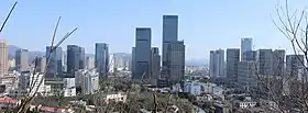 Zhoushan New Town | |
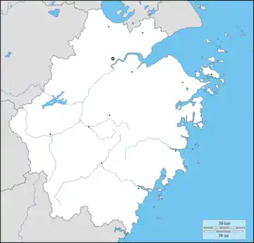 Dinghai Location in Zhejiang | |
| Coordinates (Dinghai District government): 30°01′11″N 122°06′24″E | |
| Country | People's Republic of China |
| Province | Zhejiang |
| Prefecture-level city | Zhoushan |
| Seat | Changguo Subdistrict |
| Area | |
| • Total | 1,444.0 km2 (557.5 sq mi) |
| • Land | 568.8 km2 (219.6 sq mi) |
| • Water | 875.2 km2 (337.9 sq mi) |
| Population (2019) | |
| • Total | 399,382 |
| • Density | 280/km2 (720/sq mi) |
| Time zone | UTC+8 (China Standard) |
| Postal code | 316000 |
| Website | dinghai |
| Dinghai (the former county) | |||||||||
|---|---|---|---|---|---|---|---|---|---|
| Chinese | 定海 | ||||||||
| Postal | Tinghai | ||||||||
| |||||||||
The district, which was formed in January 1987 when it was upgraded from county status, has a population of 399,382 as of 2019.[1][2]
History
According to the Dinghai People's Government, the area of Dinghai has been inhabited by humans for over 5,000 years.[2]
During the Spring and Autumn period, the area was known as Yongdong (甬东; 甬東), and belonged to the Yue state.[2]
The area was incorporated as Wenshan County (翁山县; 翁山縣) in 738 CE.[2] In 771 CE, the county was abolished and placed under Mao County (鄮县; 鄮縣).[2]
In 1073, the area was organized as Changguo County (昌国县; 昌國縣), and was placed under the jurisdiction of the Ming Prefecture.[2]
Dinghai County (定海县; 定海縣) was first established in 1688, under the Qing Dynasty.[2]
During the First Opium War, Dinghai was taken by British forces on July 6, 1840.[3] Dinghai was handed back by Charles Elliot, but was subsequently re-captured by Henry Pottinger, on October 1, 1841.[3]
Dinghai was taken by the People's Liberation Army on May 17, 1950.[2]
In October 1958, Zhoushan's prefecture-level status was revoked, and the area became part of Zhoushan County.[2] In April 1962, Zhoushan was restored to prefecture-level status, and Dinghai County was re-established.[2]
In January 1987, Dinghai County became Dinghai District (定海区).[2]
Geography

Dinghai District has a total area of 1,444.0 square kilometres, of which, 568.8 square kilometres is land, and the remaining 875.2 square kilometres is sea.[4]
The district spans 128 islands, including Zhoushan Island, Jintang Island, Damao Island (大猫岛), Cezi Island, Changbai Island, and Aoshan Island.[5] Other islands include Changzhi Island (长峙岛) and Panzhi Island (盘峙岛).[4] Many of the islands have hilly terrain, and the highest point in the district is Huangyanjian Mountain (黄杨尖山), which reaches 503.6 meters in altitude.[5]
The area is rich in marine life, with 80 species of fish, and over 150 species of shellfish.[5] The endangered black-faced spoonbill, the yellow-billed egret, the horned grebe, and other species of birds are also native to the island.[5]
Climate
The district experiences an average temperature of 16.8 °C.[5] The district's coldest month is January, which averages 6.2 °C in temperature, and the district's warmest month is August, which averages 27.4 °C in temperature.[5] The coldest temperature recorded in the district was −4.2 °C, which occurred on December 28, 1991.[5] The warmest temperature recorded in the district was 40.2 °C, which occurred on July 21, 2007.[5]
Average annual rainfall in Dinghai is 1410.8 millimetres, and the district experiences an average of 149 rainy days per year.[5]
The area experiences typhoons, heavy rains, floods, and droughts.[5] The district was hit by a blizzard on March 12, 2005, which bought the most snowfall to the area since 1978.[5]
Administrative divisions

Dinghai District administers consisted of 10 subdistricts and 3 towns.[1][6] As of 2019, these township-level divisions were further divided into 41 residential communities, 73 rural villages, and 7 urban villages.[7]
| English Name | Subdivision Type | Chinese Name | Population (2019) |
|---|---|---|---|
| Changguo Subdistrict | Subdistrict | 昌国街道; Chāngguó Jiēdào | 54,457 |
| Huannan Subdistrict | Subdistrict | 环南街道; Huánnán Jiēdào | 34,874 |
| Chengdong Subdistrict | Subdistrict | 城东街道; Chéngdōng Jiēdào | 51,578 |
| Yancang Subdistrict | Subdistrict | 盐仓街道; Yáncāng Jiēdào | 19,600 |
| Lincheng Subdistrict | Subdistrict | 临城街道; Línchéng Jiēdào | 46,886 |
| Cengang Subdistrict | Subdistrict | 岑港街道; Céngǎng Jiēdào | 18,063 |
| Ma'ao Subdistrict | Subdistrict | 马岙街道; Mǎ'ào Jiēdào | 9,653 |
| Shuangqiao Subdistrict | Subdistrict | 双桥街道; Shuāngqiáo Jiēdào | 18,170 |
| Xiaosha Subdistrict | Subdistrict | 小沙街道; Xiǎoshā Jiēdào | 19,802 |
| Qiandao Subdistrict | Subdistrict | 千岛街道; Qiāndǎo Jiēdào | 39,189 |
| Jintang | Town | 金塘镇; Jīntáng Zhèn | 40,074 |
| Baiquan | Town | 白泉镇; Báiquán Zhèn | 37,144 |
| Ganlan | Town | 干𬒗镇; Gànlán Zhèn | 9,892 |
Historic divisions
In July 1994, the district had 4 subdistricts, 7 towns, and 14 townships.[8] The district's 4 subdistricts were Changguo Subdistrict, Huannan Subdistrict, Chengdong Subdistrict, and the now-defunct Jiefang Subdistrict.[8] The district's 7 towns were Xiaosha (now a subdistrict), Cengang (now a subdistrict), Lincheng (now a subdistrict), Baiquan, Ganlan, the now-defunct Dafeng (大丰镇), and the now-defunct Ligang (沥港镇).[8] The district's 14 townships were Ma'ao Township (now a subdistrict), Shantan Township (山潭乡), Changbai Township (长白乡), Dasha Township (大沙乡), Yandun Township (烟墩乡), Mamu Township (马目乡), Cezi Township (册子乡), Shijiao Township (石礁乡), Yancang Township (now a subdistrict), Ziwei Township (紫微乡), Changzhi Township (长峙乡), Beichan Township (北蝉乡), Panzhi Township (盘峙乡), and Damao Township (大猫乡).[8]
By 2000, Ma'ao was promoted from a township to a town.[8]
In September 2004, Lincheng was promoted from a town to a subdistrict.[7]
In May 2008, the town of Jintang was set up.[7]
In 2017, Qiandao Subdistrict split off from Lincheng Subdistrict.[7]
Demographics
As of 2019, Dinghai District has a population of 399,382 people, an increase of 1,813 (0.456%) from 2018.[1] The district has 96.58 males per 100 females.[1]
In the 2000 Chinese Census, the district had a population of 369,448.[8]
References
- 人口状况 [Population Situation] (in Chinese). Dinghai People's Government. 2020-03-04. Archived from the original on 2020-08-13. Retrieved 2020-08-13.
- 历史沿革 [History] (in Chinese). Dinghai People's Government. 2018-05-11. Archived from the original on 2020-08-13. Retrieved 2020-08-13.
- Dillon, Michael (2012). China: A modern history (New paperback ed.). London. pp. 52, 57. ISBN 978-1-78076-381-1. OCLC 793689711.
- 定海区概况地图. xzqh.org (in Chinese). 2013-11-14. Archived from the original on 2020-08-13. Retrieved 2020-08-13.
- 自然地理 [Physical Geography] (in Chinese). Dinghai District People's Government. 2015-12-04. Archived from the original on 2020-08-13. Retrieved 2020-08-13.
- 2019年统计用区划代码 (in Chinese). National Bureau of Statistics of China. 2019. Archived from the original on 2020-08-13. Retrieved 2020-08-13.
- 行政区划 [Administrative Divisions] (in Chinese). Dinghai People's Government. 2020-04-27. Archived from the original on 2020-08-13. Retrieved 2020-08-13.
- 定海区历史沿革. xzqh.org (in Chinese). 2013-11-14. Archived from the original on 2020-08-13. Retrieved 2020-08-13.
- http://www.zhoushan.gov.cn/html/233415.html%5B%5D
External links
- Official site (in Chinese)