Dolní Studénky
Dolní Studénky (German: Schönbrunn) is a municipality and village in Šumperk District in the Olomouc Region of the Czech Republic. It has about 1,400 inhabitants.
Dolní Studénky | |
|---|---|
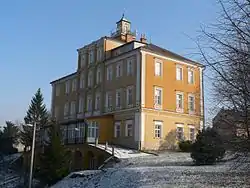 Třemešek Château | |
 Flag  Coat of arms | |
 Dolní Studénky Location in the Czech Republic | |
| Coordinates: 49°56′6″N 16°58′16″E | |
| Country | |
| Region | Olomouc |
| District | Šumperk |
| First mentioned | 1353 |
| Area | |
| • Total | 8.53 km2 (3.29 sq mi) |
| Elevation | 320 m (1,050 ft) |
| Population (2020-01-01[1]) | |
| • Total | 1,372 |
| • Density | 160/km2 (420/sq mi) |
| Time zone | UTC+1 (CET) |
| • Summer (DST) | UTC+2 (CEST) |
| Postal code | 788 20 |
| Website | www |
Dolní Studénky lies approximately 4 kilometres (2 mi) south of Šumperk, 43 km (27 mi) north-west of Olomouc, and 184 km (114 mi) east of Prague.
Administrative parts
Village of Králec is an administrative part of Dolní Studénky.
Demography
The municipality experienced steady growth until World War II when hundreds of German citizens were forced to leave. During the communist regime the population rose back and as of now the populations is on its historical peak.[2]
|
|
Culture
Annual international music festival Hudba bez hranic (Music Without Borders) takes place in Dolní Studénky.
References
- "Population of Municipalities – 1 January 2020". Czech Statistical Office. 2020-04-30.
- "Historický lexikon obcí České republiky – 1869–2011: Okres Šumperk" (in Czech). Czech Statistical Office. 2015-12-21. pp. 1, 2.
| Wikimedia Commons has media related to Dolní Studénky. |
| Authority control |
|
|---|
This article is issued from Wikipedia. The text is licensed under Creative Commons - Attribution - Sharealike. Additional terms may apply for the media files.