Domleschg (Kreis)
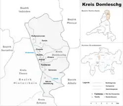
The Kreis Domleschg forms, together with the sub-districts of Avers, Rheinwald, Schams and Thusis, the Hinterrhein District of the Canton Graubünden in Switzerland. The district office is located in Fürstenau.
Kreis Domleschg
Kreis Domleschg | |
|---|---|
Sub-district | |
 | |
| Country | |
| Canton | |
| Capital | Fürstenau |
| Area | |
| • Total | 73.94 km2 (28.55 sq mi) |
| Population (2009) | |
| • Total | 4,278 |
| • Density | 58/km2 (150/sq mi) |
| Time zone | UTC+1 (CET) |
| • Summer (DST) | UTC+2 (CEST) |
| Municipalities | 5 |
Geography
Geographically, the Kreis is located in the lower part of the Hinterrhein, below the Viamala gorge, on the left bank of the river. This part of the valley is known as the Domleschg/Heinzenberg valley. The right bank forms the Kreis Thusis.
Municipalities
| Coat of arms | Name | Residents (Dec. 2009) |
Area in km2 |
BFS No. |
|---|---|---|---|---|
| Domleschg | 2,113 | 45.94 | 3673 | |
| Fürstenau | 357 | 1.32 | 3633 | |
| Rothenbrunnen | 304 | 3.11 | 3637 | |
| Scharans | 790 | 14.29 | 3638 | |
| Sils im Domleschg | 960 | 9.28 | 3640 |
Mergers
On 1 January 2015 the former municipalities of Almens, Paspels, Pratval, Rodels and Tomils merged to form the new municipality of Domleschg.[1]
References
- Amtliches Gemeindeverzeichnis der Schweiz published by the Swiss Federal Statistical Office (in German) accessed 2 January 2013
External links
| Wikimedia Commons has media related to Kreis Domleschg. |
- Domleschg in German, French and Italian in the online Historical Dictionary of Switzerland.
This article is issued from Wikipedia. The text is licensed under Creative Commons - Attribution - Sharealike. Additional terms may apply for the media files.