Rothenbrunnen
Rothenbrunnen (Giuvaulta in romansh) is a municipality in the Viamala Region in the Swiss canton of Graubünden.
Rothenbrunnen | |
|---|---|
 | |
 Coat of arms | |
Location of Rothenbrunnen 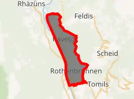
| |
 Rothenbrunnen Rothenbrunnen | |
| Coordinates: 46°46′N 9°25′E | |
| Country | Switzerland |
| Canton | Graubünden |
| District | Viamala |
| Area | |
| • Total | 3.11 km2 (1.20 sq mi) |
| Elevation | 625 m (2,051 ft) |
| Population (2018-12-31)[2] | |
| • Total | 299 |
| • Density | 96/km2 (250/sq mi) |
| Time zone | UTC+01:00 (Central European Time) |
| • Summer (DST) | UTC+02:00 (Central European Summer Time) |
| Postal code(s) | 7405 |
| SFOS number | 3637 |
| Surrounded by | Cazis, Domat/Ems, Feldis/Veulden, Rhäzüns, Scheid, Tumegl/Tomils |
| Website | www SFSO statistics |
History
Rothenbrunnen is first mentioned in 1472 as Hof Juvalt. In 1572 it was mentioned as zum Roten Brunnen.[3]
Geography
Rothenbrunnen has an area, as of 2006, of 3.1 km2 (1.2 sq mi). Of this area, 11.6% is used for agricultural purposes, while 67.7% is forested. Of the rest of the land, 9.4% is settled (buildings or roads) and the remainder (11.3%) is non-productive (rivers, glaciers or mountains).[4]
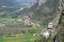
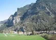
Before 2017, the municipality was located in the Domleschg sub-district, of the Hinterrhein district, after 2017 it was part of the Viamala Region.[5] It is a linear village on the right hand side of the Hinterrhine river. It also includes the settlement of Ravetsch (Romansh: Ravetg)
Coat of arms
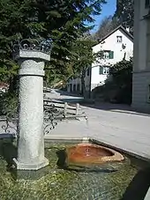
The municipality's coat of arms is Argent a Fountain proper Gules and in Chief Azure a Mullet Or.[6] This is an example of canting where the name of the municipality is translated or represented on the coat of arms. In this case, in German Rothen means red and brunnen means fountain. The fountain refers to the source of medicinal waters for which the municipality was known.
The coat of arms is also the coat of arms of the Friie von Juvalta, but modified with a star. The coat of arms of the friie was: D'azur à l'étoile de cinq / six pointes d'argent / or. Later, the coat of arms was augmentend to taillé, d'azur à l'étoile de cinq / six pointes d'argent / or et d'or à l'aiglon de gueules. All these variants or brisure where chosen to distinguish the older from the younger brother(s).
Demographics
Rothenbrunnen has a population (as of 31 December 2019) of 304.[7] As of 2008, 11.2% of the population was made up of foreign nationals. Over the last 10 years the population has decreased at a rate of -6.5%.[4]
As of 2000, the gender distribution of the population was 47.5% male and 52.5% female.[8] The age distribution, as of 2000, in Rothenbrunnen is; 58 people or 13.7% of the population are between 0 and 9 years old. 28 people or 6.6% are 10 to 14, and 39 people or 9.2% are 15 to 19. Of the adult population, 38 people or 9.0% of the population are between 20 and 29 years old. 70 people or 16.6% are 30 to 39, 67 people or 15.9% are 40 to 49, and 68 people or 16.1% are 50 to 59. The senior population distribution is 31 people or 7.3% of the population are between 60 and 69 years old, 11 people or 2.6% are 70 to 79, there are 8 people or 1.9% who are 80 to 89, and there are 4 people or 0.9% who are 90 to 99.[9]
In the 2007 federal election the most popular party was the SVP which received 44.6% of the vote. The next three most popular parties were the SPS (22.4%), the FDP (15%) and the CVP (10.5%).[4]
In Rothenbrunnen about 58.1% of the population (between age 25-64) have completed either non-mandatory upper secondary education or additional higher education (either university or a Fachhochschule).[4]
Rothenbrunnen has an unemployment rate of 1.29%. As of 2005, there were 11 people employed in the primary economic sector and about 4 businesses involved in this sector. 31 people are employed in the secondary sector and there are 5 businesses in this sector. 230 people are employed in the tertiary sector, with 13 businesses in this sector.[4]
The historical population is given in the following table:[3][8]
| year | population |
|---|---|
| 1803 | 64 |
| 1900 | 77 |
| 1950 | 247 |
| 1960 | 292 |
| 1970 | 319 |
| 1980 | 403 |
| 1990 | 330 |
| 2000 | 422 |
Languages
Most of the population (as of 2000) speaks German (83.2%), with Romansh being second most common ( 7.6%) and Portuguese being third ( 2.1%).[4]
| Languages in Rothenbrunnen | ||||||
| Languages | Census 1980 | Census 1990 | Census 2000 | |||
| Number | Percent | Number | Percent | Number | Percent | |
| German | 265 | 65.76% | 254 | 76.97% | 351 | 83.18% |
| Romanish | 44 | 10.92% | 32 | 9.70% | 32 | 7.58% |
| Italian | 69 | 17.12% | 11 | 3.33% | 7 | 1.66% |
| Population | 403 | 100% | 330 | 100% | 422 | 100% |
Heritage sites of national significance
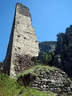
The ruins of Hochjuvalt Castle are listed as a Swiss heritage sites of national significance.[10]
Weather
Rothenbrunnen has an average of 101.1 days of rain per year and on average receives 850 mm (33 in) of precipitation. The wettest month is August during which time Rothenbrunnen receives an average of 105 mm (4.1 in) of precipitation. During this month there is precipitation for an average of 10.9 days. The driest month of the year is February with an average of 45 mm (1.8 in) of precipitation over 10.9 days.[11]
Transportation
Rhaetian Railway operate services to Rothenbrunnen (Rhaetian Railway station).
References
- "Arealstatistik Standard - Gemeinden nach 4 Hauptbereichen". Federal Statistical Office. Retrieved 13 January 2019.
- "Ständige Wohnbevölkerung nach Staatsangehörigkeitskategorie Geschlecht und Gemeinde; Provisorische Jahresergebnisse; 2018". Federal Statistical Office. 9 April 2019. Retrieved 11 April 2019.
- Rothenbrunnen in German, French and Italian in the online Historical Dictionary of Switzerland.
- Swiss Federal Statistical Office accessed 05-Oct-2009
- Swiss Federal Statistical Office - Amtliches Gemeindeverzeichnis der Schweiz - Mutationsmeldungen 2016 accessed 16 February 2017
- Flags of the world accessed 5 October 2009
- "Ständige und nichtständige Wohnbevölkerung nach institutionellen Gliederungen, Geburtsort und Staatsangehörigkeit". bfs.admin.ch (in German). Swiss Federal Statistical Office - STAT-TAB. 31 December 2019. Retrieved 6 October 2020.
- Graubunden in Numbers Archived 2009-09-24 at the Wayback Machine (in German) accessed 21 September 2009
- Graubunden Population Statistics Archived 2009-08-27 at the Wayback Machine (in German) accessed 21 September 2009
- Swiss inventory of cultural property of national and regional significance Archived 2009-05-01 at the Wayback Machine 21.11.2008 version, (in German) accessed 05-Oct-2009
- "Temperature and Precipitation Average Values-Table, 1961-1990" (in German, French, and Italian). Federal Office of Meteorology and Climatology - MeteoSwiss. Archived from the original on 27 June 2009. Retrieved 8 May 2009., the weather station elevation is 622 meters above sea level.
| Wikimedia Commons has media related to Rothenbrunnen. |