Dundas, New South Wales
Dundas is a suburb of Sydney, New South Wales, Australia. Dundas is located 21 kilometres north-west of the Sydney central business district, in the local government area of the City of Parramatta, and the electoral division of Bennelong. Dundas is a leafy green suburb, notably due to its centrepiece The Ponds Walk, which follows the Ponds Subiaco Creek. Dundas is part of the Northern Sydney[2] and Greater Western Sydney[3] regions.
| Dundas Sydney, New South Wales | |||||||||||||||
|---|---|---|---|---|---|---|---|---|---|---|---|---|---|---|---|
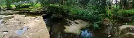 The Ponds Creek, Dundas | |||||||||||||||
| Population | 4,740 (2016 census)[1] | ||||||||||||||
| • Density | 3,650/km2 (9,400/sq mi) | ||||||||||||||
| Postcode(s) | 2117 | ||||||||||||||
| Area | 1.3 km2 (0.5 sq mi) | ||||||||||||||
| Location | 21 km (13 mi) NW of Sydney CBD | ||||||||||||||
| LGA(s) | City of Parramatta | ||||||||||||||
| State electorate(s) | Parramatta | ||||||||||||||
| Federal Division(s) | |||||||||||||||
| |||||||||||||||
History
Dundas and surrounding areas were originally known as "The Ponds", a name still reflected in The Ponds Creek. The first private land grants in Sydney made in 1791 were in what is now North East Dundas and adjoining Dundas Valley and Ermington.
The name Dundas was first used in the area in 1799, named for the Dundas family of Scotland. There are over 100 places named in their honour, mostly in parts of the former British Empire.[4]
Heritage listings
Dundas has a number of heritage-listed sites, including(but not limited to):
- Station Street: Dundas railway station[5]
Population
According to the 2016 census, there were 4,740 residents in Dundas. 48.3% of people were born in Australia. The most common countries of birth were China 12.0% and South Korea 6.5%. 46.4% of people only spoke English at home. Other languages spoken at home included Mandarin 13.2%, Korean 8.0%, Cantonese 7.4% and Arabic 2.6%. The most common responses for religion were No Religion 27.4% and Catholic 25.0%. The majority of households were families (77.8%) and there were also single person households (18.6%).[1]
Transport
Dundas railway station is on the closed Carlingford line of the Sydney Trains network. The heritage listed station is located on Station Street, connects to Kissing Point Road by footpath. The conversion of the Camellia to Carlingford section of the Carlingford railway line to light rail was announced in 2015 as part of the Parramatta Light Rail project and the station closed 5 January 2020.[6] The station area is now served by temporary bus route 535 between Carlingford and Parramatta. [7]
State Transit routes that pass through Dundas include the 545 a Parramatta to Chatswood service via Kissing Point Road and the 521, a Parramatta to Eastwood service via Park Road.
Schools
- St Patrick's Marist College Dundas, located on Kirby Street, is a Catholic secondary school and plays host to the Shamrocks Dundas JRLFC Football Club.
- Dundas Public School is located between Kissing Point Road and Calder Road.
Churches
- Dundas Ermington Uniting Church is located on the corner of Kissing Point Road and Park Road in Dundas.
- The Church of Scientology's Sydney Rehabilitation Project Force is located in Dundas.[8]
References
- Australian Bureau of Statistics (27 June 2017). "Dundas (State Suburb)". 2016 Census QuickStats. Retrieved 11 August 2017.

- https://postcodez.com.au/postcodes.cgi?search_suburb=Dundas&search_state=nsw&type=search
- https://www.wslhd.health.nsw.gov.au/Mental-Health-Services/Our-Services
- "Dundas". Geographical Names Register (GNR) of NSW. Geographical Names Board of New South Wales. Retrieved 5 August 2013.
- "Dundas Railway Station". New South Wales State Heritage Register. Office of Environment and Heritage. H01133. Retrieved 18 May 2018.
- "Parramatta Light Rail - How the preferred network was chosen". Transport for NSW. Archived from the original on 10 December 2015. Retrieved 8 December 2015.
- "Hillsbus route 535". Transport for NSW.
- Ortega, Tony (14 February 2012). "Scientology's Shocking Treatment of Children Held in a Suburban Labor Camp". Blogs.villagevoice.com. Retrieved 27 November 2013.