Dwarskersbos
Dwarskersbos is a settlement in West Coast District Municipality in the Western Cape province of South Africa.
Dwarskersbos | |
|---|---|
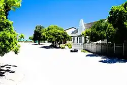 Beach House in Dwarskersbos | |
 Dwarskersbos  Dwarskersbos | |
| Coordinates: 32°42′S 18°14′E | |
| Country | South Africa |
| Province | Western Cape |
| District | West Coast |
| Municipality | Bergrivier |
| Area | |
| • Total | 1.53 km2 (0.59 sq mi) |
| Population (2011)[1] | |
| • Total | 670 |
| • Density | 440/km2 (1,100/sq mi) |
| Racial makeup (2011) | |
| • Black African | 29.9% |
| • Coloured | 9.7% |
| • Indian/Asian | 2.7% |
| • White | 57.5% |
| • Other | 0.1% |
| First languages (2011) | |
| • Afrikaans | 94.5% |
| • English | 4.5% |
| • Other | 1.0% |
| Time zone | UTC+2 (SAST) |
| Area code | 022 |
| Website | www.dwarskersbos.com |
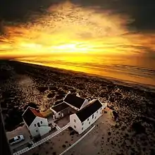
Sunset shot over a beach house in Dwarskersbos.
Fishing village some 11 km north of Laaiplek. Near here the Portuguese navigator Vasco da Gama first set foot on South African soil on 7 November 1497 when he explored the present St Helena Bay. A 6m high storm surge struck Dwarskersbos on 27 August 1969. The name is said to be derived from Afrikaans; kersbos is a type of plant, Euclea polyandra, or Sarcocaulon species. The beach stretches from Velddrif and Dwarskerbos to Elands Bay, making it the longest uninterrupted sandy beach in South Africa. [2]
References
- "Main Place Dwarskersbos". Census 2011.
- "Dictionary of Southern African Place Names (Public Domain)". Human Science Research Council. p. 148.
Municipalities and communities of West Coast District Municipality, Western Cape | ||
|---|---|---|
District seat: Moorreesburg | ||
| Matzikama | .svg.png.webp) West Coast District within South Africa | |
| Cederberg | ||
| Bergrivier | ||
| Saldanha Bay | ||
| Swartland | ||
This article is issued from Wikipedia. The text is licensed under Creative Commons - Attribution - Sharealike. Additional terms may apply for the media files.