Porterville, Western Cape
Porterville is a town in the Western Cape province of South Africa.
Porterville | |
|---|---|
  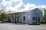 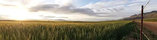 From the top, an aerial photograph of Porterville in South Africa with the R44 road running through the town. In the left photograph, the Grootwinterhoek mountains can be seen in the distance. NG Kerk in Porterville (left). The Jan Danckaert Museum (right). Wheat is grown in the surrounding area (below). | |
 Porterville  Porterville | |
| Coordinates: 33°00′S 18°59′E | |
| Country | South Africa |
| Province | Western Cape |
| District | West Coast |
| Municipality | Bergrivier |
| Area | |
| • Total | 7.98 km2 (3.08 sq mi) |
| Population (2011)[1] | |
| • Total | 7,057 |
| • Density | 880/km2 (2,300/sq mi) |
| Racial makeup (2011) | |
| • Black African | 1.6% |
| • Coloured | 76.4% |
| • Indian/Asian | 0.4% |
| • White | 21.0% |
| • Other | 0.6% |
| First languages (2011) | |
| • Afrikaans | 96.0% |
| • English | 1.9% |
| • Other | 2.1% |
| Time zone | UTC+2 (SAST) |
| Postal code (street) | 6810, 6811, 6812 |
| PO box | 6810 |
| Area code | 022 |
The town is located at the foot of the Olifants River Mountains, 27 km south-east of Piketberg and 155 km north-east of Cape Town. It was laid out in 1863 on Pomona's farm, previously owned by Willems Vallei, and became a municipality in 1903. It is situated 140 km north of Cape Town on R44 road at the base of the Olifants River mountains. Agriculture in the area is dominated by wheat production.
The town was established in 1863 and named after William Porter, who served as Attorney General of the Cape Colony from 1839 to 1866.[2]
Demographics
| Year | Pop. | ±% |
|---|---|---|
| 2001 | 5,863 | — |
| 2011 | 7,057 | +20.4% |
| [3][1] | ||
According to the 2011 census, Porterville has a population of 7,057 people divided into 1,949 households. The census identifies residents' first languages as 96.0% Afrikaans, 1.9% English and 2.1% other. Within the population, 76.4% of residents identified themselves as "Coloured", 21.0% as "White" and 1.6% as "Black African".[1] Porterville has an area of about 7.98 square km, with a density of 884.3 per square km. Minor area differences exist between figures extracted from the 2001 and 2011 censuses.
Things to do
Porterville is home to the Porterville Farmer's Market, a community-driven market located 1km outside of town. Other attractions include Beaverlac camping site, 22 waterfalls, paragliding, hang gliding, and numerous restaurants and art galleries.
Notable people
- Pieter Grobbelaar, South African World War II military commander was born in Porterville.
- Andrew Beerwinkel, South African rugby union player grew up in Porterville.
- Nataniël le Roux, South African TV personality, singer, writer, and composer[4]
References
- "Main Place Porterville". Census 2011.
- "Dictionary of Southern African Place Names (Public Domain)". Human Science Research Council. p. 372.
- , Census 2001 — Main Place "Porterville"
- "Nataniël's table". www.lecreuset.co.za. Retrieved 2020-10-06.
Municipalities and communities of West Coast District Municipality, Western Cape | ||
|---|---|---|
District seat: Moorreesburg | ||
| Matzikama | .svg.png.webp) West Coast District within South Africa | |
| Cederberg | ||
| Bergrivier | ||
| Saldanha Bay | ||
| Swartland | ||