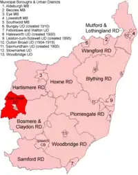
East Stow Rural District
East Stow was a rural district in East Suffolk, England from 1894 to 1934.
| East Stow | |
|---|---|
 Location within East Suffolk, 1894 | |
| History | |
| • Created | 1894 |
| • Abolished | 1934 |
| • Succeeded by | Gipping Rural District |
| Status | Rural district |
It was created under the Local Government Act 1894, from the part of the Stow rural sanitary district that was in East Suffolk (the rest forming Thedwastre Rural District in West Suffolk.)
It was abolished in 1934 under a County Review Order. Its area went to form part of Gipping Rural District, with a small part being transferred to Stowmarket urban district.[1] In 1974 the area became part of Mid Suffolk district.
Statistics
| Year | Area[2] | Population [3] |
Density (pop/ha) | |
|---|---|---|---|---|
| acres | ha | |||
| 1911 | 21,647 | 8,760 | 6,223 | 0.71 |
| 1921 | 6,330 | 0.72 | ||
| 1931 | 7,236 | 0.83 | ||
Parishes
East Stow RD contained the parishes of Buxhall, Combs, Creeting St Peter, Gipping, Great Finborough, Harleston, Haughley, Little Finborough, Old Newton, Onehouse, Shelland, Stowupland and Wetherden.
References
- "East Stow RD through time: Census tables with data for the Local Government District". A Vision of Britain through Time. GB Historical GIS / University of Portsmouth. Retrieved 9 July 2017.
- "East Stow RD through time: Population Statistics: Area (acres)". A Vision of Britain through Time. GB Historical GIS / University of Portsmouth. Retrieved 9 July 2017.
- "East Stow RD through time: Population Statistics: Total Population". A Vision of Britain through Time. GB Historical GIS / University of Portsmouth. Retrieved 9 July 2017.
This article is issued from Wikipedia. The text is licensed under Creative Commons - Attribution - Sharealike. Additional terms may apply for the media files.