Thedwastre Rural District
Thedwastre was a rural district in West Suffolk, England from 1894 to 1974. It was formed under the Local Government Act 1894, from the part of the Stow Rural Sanitary District which was in West Suffolk (the rest forming East Stow Rural District in East Suffolk). It was named after the historic hundred of Thedwastre.
| Thedwastre | |
|---|---|
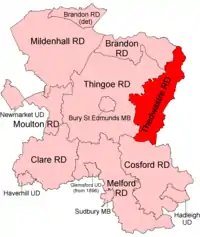 Location within West Suffolk, 1894 | |
| Area | |
| • 1901 | 34,126 acres (138.1 km²) |
| • 1971 | 34,126 acres (138.1 km²) |
| Population | |
| • 1901 | 9,075 |
| • 1971 | 10,692 |
| History | |
| • Created | 1894 |
| • Abolished | 1974 |
| Status | Rural district |
| • HQ | Thurston |
The district was abolished in 1974, under the Local Government Act 1972, and went to form part of the Mid Suffolk district in Suffolk. Its boundaries never changed during its 80 years existence.[1]
Parishes
The rural district comprised the following civil parishes:[2]
Statistics
| Year | Area[3] | Population [4] |
Density (pop/ha) | |
|---|---|---|---|---|
| acres | ha | |||
| 1911 | 34,126 | 13,810 | 9,018 | 0.65 |
| 1921 | 8,492 | 0.61 | ||
| 1931 | 8,039 | 0.58 | ||
| 1951 | 8,870 | 0.64 | ||
| 1961 | 9,270 | 0.67 | ||
References
- "Thedwastre RD through time: Census tables with data for the Local Government District". A Vision of Britain through Time. GB Historical GIS / University of Portsmouth. Retrieved 8 July 2017.
- "Thedwastre RD through time | Census tables with data for the Local Government District". www.visionofbritain.org.uk. Retrieved 25 October 2020.
- "Thedwastre RD through time: Population Statistics: Area (acres)". A Vision of Britain through Time. GB Historical GIS / University of Portsmouth. Retrieved 8 July 2017.
- "Thedwastre RD through time: Population Statistics: Total Population". A Vision of Britain through Time. GB Historical GIS / University of Portsmouth. Retrieved 8 July 2017.
| Pre-1974 |
| ||||||
|---|---|---|---|---|---|---|---|
| Post-1974 | |||||||
This article is issued from Wikipedia. The text is licensed under Creative Commons - Attribution - Sharealike. Additional terms may apply for the media files.