Blyth Rural District
Blyth Rural District was a rural district in East Suffolk, England, between 1934 and 1974.
| Blyth | |
|---|---|
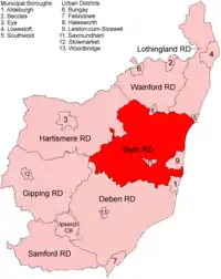 Location within East Suffolk, 1934 | |
| History | |
| • Created | 1934 |
| • Abolished | 1974 |
| • Succeeded by | Suffolk Coastal |
| Status | Rural district |
The rural district was formed by the merger of parts of Blything Rural District and Plomesgate Rural District with a small parts of Hoxne RD, all of which were being abolished.[1] It covered a coastal area north of Aldeburgh and inland parishes around Saxmundham.
The district was abolished in 1974 under the Local Government Act 1972, and became part of Suffolk Coastal district.
Statistics
| Year | Area[2] | Population [3] |
Density (pop/ha) | |
|---|---|---|---|---|
| acres | ha | |||
| 1939 | 21,215 | |||
| 1951 | 98,184 | 39,734 | 19,281 | 0.49 |
| 1961 | 98,182 | 39,733 | 18,600 | 0.47 |
Parishes
Parishes formerly in Blything Rural District:
Formerly in Plomesgate Rural District:
Formerly in Hoxne Rural District:
References
- "Blyth RD through time: Census tables with data for the Local Government District". A Vision of Britain through Time. GB Historical GIS / University of Portsmouth. Retrieved 10 July 2017.
- "Blyth RD through time: Population Statistics: Area (acres)". A Vision of Britain through Time. GB Historical GIS / University of Portsmouth. Retrieved 10 July 2017.
- "Blyth RD through time: Population Statistics: Total Population". A Vision of Britain through Time. GB Historical GIS / University of Portsmouth. Retrieved 10 July 2017.
| Pre-1974 |
| ||||||
|---|---|---|---|---|---|---|---|
| Post-1974 | |||||||
This article is issued from Wikipedia. The text is licensed under Creative Commons - Attribution - Sharealike. Additional terms may apply for the media files.
