Egesheim
Egesheim is a town in the district of Tuttlingen in Baden-Württemberg in Germany.
Egesheim | |
|---|---|
 Coat of arms | |
Location of Egesheim within Tuttlingen district 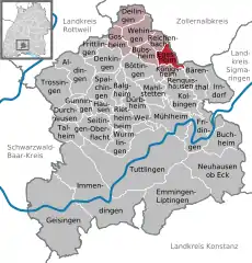 | |
 Egesheim  Egesheim | |
| Coordinates: 48°07′01″N 08°51′21″E | |
| Country | Germany |
| State | Baden-Württemberg |
| Admin. region | Freiburg |
| District | Tuttlingen |
| Government | |
| • Mayor | Josef Bär |
| Area | |
| • Total | 7.66 km2 (2.96 sq mi) |
| Elevation | 783 m (2,569 ft) |
| Population (2019-12-31)[1] | |
| • Total | 652 |
| • Density | 85/km2 (220/sq mi) |
| Time zone | UTC+01:00 (CET) |
| • Summer (DST) | UTC+02:00 (CEST) |
| Postal codes | 78592 |
| Dialling codes | 07429 |
| Vehicle registration | TUT |
| Website | www.egesheim.de |
Geography
Egesheim lies on the Heuberg Plateau in the southwest of the Swabian Jura at an altitude of between 700 metres (2,300 ft) and 930 metres (3,050 ft) above sea level. The southern branch of the Bära river flows through the town. Approximately two-thirds of the area is forest.
History
Heidentor
Thre Heidentor is a celtic places of worship.[2] The town is one of the oldest communities in the region, In 770 it is mentioned in a deed of donation of the Abbey of Saint Gall. Various religious and secular lordships have claimed ownership. In 1381 the village became a domain of Further Austria, and remained so until 1805, when it became part of Württemberg.
Demographics
As of 2011, Egesheim is estimated to have a population of around 643.[3]
It has an area of 766 square kilometres (296 sq mi), with a population density of around 84 people per square kilometre.[4]
External links
References
- "Bevölkerung nach Nationalität und Geschlecht am 31. Dezember 2019". Statistisches Landesamt Baden-Württemberg (in German). September 2020.
- Heidentor
- http://www.citypopulation.de/php/germany-badenwurttemberg.php?cityid=08327013
- http://www.citypopulation.de/php/germany-badenwurttemberg.php?cityid=08327013
| Authority control |
|---|