Ehrwald
Ehrwald is a municipality in the district of Reutte in the Austrian state of Tyrol.

The Roman Catholic Church of the Visitation of Mary, Ehrwald
Ehrwald | |
|---|---|
 | |
 Coat of arms | |
 Ehrwald Location within Austria | |
| Coordinates: 47°23′59″N 10°55′00″E | |
| Country | Austria |
| State | Tyrol |
| District | Reutte |
| Government | |
| • Mayor | Martin Hohenegg |
| Area | |
| • Total | 49.44 km2 (19.09 sq mi) |
| Elevation | 994 m (3,261 ft) |
| Population (2018-01-01)[2] | |
| • Total | 2,593 |
| • Density | 52/km2 (140/sq mi) |
| Time zone | UTC+1 (CET) |
| • Summer (DST) | UTC+2 (CEST) |
| Postal code | 6632 |
| Area code | 05673 |
| Vehicle registration | RE |
| Website | www.riskommunal.net/ ehrwald |
Geography
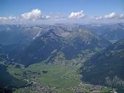
Ehrwald lies at the southern base of the Zugspitze (2950 meters above sea level), Germany's highest mountain, but which is shared with Austria. The town is connected to the Zugspitze with the Tyrolean Aerial Tramway.
Climate
Ehrwald has a humid continental climate (Koppen: Dfb) with four distinct seasons. Summers are very pleasant, with mild to warm days and cool nights. Winters are relatively cold and snowy, with average annual snowfall totalling 128 inches (325 cm). Precipitation is very reliable year round, but markedly more so during the summer months.
| Climate data for Ehrwald (1971–2000) | |||||||||||||
|---|---|---|---|---|---|---|---|---|---|---|---|---|---|
| Month | Jan | Feb | Mar | Apr | May | Jun | Jul | Aug | Sep | Oct | Nov | Dec | Year |
| Record high °C (°F) | 15.3 (59.5) |
17.7 (63.9) |
22.0 (71.6) |
24.1 (75.4) |
28.4 (83.1) |
31.8 (89.2) |
33.3 (91.9) |
33.8 (92.8) |
30.4 (86.7) |
26.5 (79.7) |
19.2 (66.6) |
14.8 (58.6) |
33.8 (92.8) |
| Average high °C (°F) | 2.5 (36.5) |
4.1 (39.4) |
7.7 (45.9) |
10.7 (51.3) |
16.4 (61.5) |
18.8 (65.8) |
21.3 (70.3) |
21.0 (69.8) |
17.8 (64.0) |
13.4 (56.1) |
6.2 (43.2) |
2.7 (36.9) |
11.9 (53.4) |
| Daily mean °C (°F) | −2.3 (27.9) |
−1.6 (29.1) |
1.6 (34.9) |
4.6 (40.3) |
9.9 (49.8) |
12.6 (54.7) |
14.7 (58.5) |
14.4 (57.9) |
11.0 (51.8) |
6.9 (44.4) |
1.2 (34.2) |
−1.6 (29.1) |
6.0 (42.8) |
| Average low °C (°F) | −5.9 (21.4) |
−5.3 (22.5) |
−2.3 (27.9) |
0.4 (32.7) |
4.9 (40.8) |
7.9 (46.2) |
9.6 (49.3) |
9.8 (49.6) |
6.7 (44.1) |
3.0 (37.4) |
−2.0 (28.4) |
−4.8 (23.4) |
1.8 (35.2) |
| Record low °C (°F) | −28.5 (−19.3) |
−24.7 (−12.5) |
−21.5 (−6.7) |
−11.1 (12.0) |
−5.2 (22.6) |
−1.2 (29.8) |
1.0 (33.8) |
0.4 (32.7) |
−3.6 (25.5) |
−8.0 (17.6) |
−18.6 (−1.5) |
−21.5 (−6.7) |
−28.5 (−19.3) |
| Average precipitation mm (inches) | 78.2 (3.08) |
69.6 (2.74) |
86.1 (3.39) |
83.7 (3.30) |
117.6 (4.63) |
164.0 (6.46) |
177.8 (7.00) |
154.6 (6.09) |
108.8 (4.28) |
80.0 (3.15) |
88.2 (3.47) |
83.8 (3.30) |
1,292.4 (50.88) |
| Average snowfall cm (inches) | 59.1 (23.3) |
72.2 (28.4) |
70.2 (27.6) |
23.4 (9.2) |
2.9 (1.1) |
0.0 (0.0) |
0.0 (0.0) |
0.0 (0.0) |
0.0 (0.0) |
2.9 (1.1) |
37.8 (14.9) |
57.0 (22.4) |
325.5 (128.1) |
| Average precipitation days (≥ 1.0 mm) | 10.3 | 9.1 | 12.1 | 12.5 | 13.8 | 16.2 | 15.8 | 14.6 | 11.7 | 10.0 | 10.3 | 11.2 | 147.6 |
| Average relative humidity (%) (at 14:00) | 62.7 | 58.4 | 53.5 | 53.1 | 51.9 | 54.5 | 53.0 | 55.1 | 54.6 | 54.9 | 63.0 | 65.7 | 56.7 |
| Source: Central Institute for Meteorology and Geodynamics[3] | |||||||||||||
References
- "Dauersiedlungsraum der Gemeinden Politischen Bezirke und Bundesländer - Gebietsstand 1.1.2018". Statistics Austria. Retrieved 10 March 2019.
- "Einwohnerzahl 1.1.2018 nach Gemeinden mit Status, Gebietsstand 1.1.2018". Statistics Austria. Retrieved 9 March 2019.
- "Klimadaten von Österreich 1971–2000 – Tirol-Ehrwald" (in German). Central Institute for Meteorology and Geodynamics. Archived from the original on 12 October 2019. Retrieved 20 October 2019.
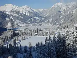
The snow-covered Alps near Ehrwald, Austria, in the winter
This article is issued from Wikipedia. The text is licensed under Creative Commons - Attribution - Sharealike. Additional terms may apply for the media files.