Reutte
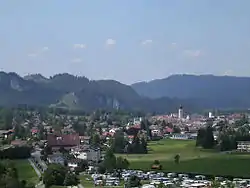
Reutte (Swabian: Raete) is a market town in the Austrian state of Tyrol. It is the administrative center of the Reutte district (Districts of Austria). Reutte is located on the Lech, and has a population of 6704 (as of 2018).
Reutte
Raete | |
|---|---|
 | |
 Coat of arms | |
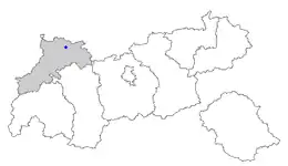 Location in Tyrol | |
 Reutte Location within Austria | |
| Coordinates: 47°29′00″N 10°43′00″E | |
| Country | Austria |
| State | Tyrol |
| District | Reutte |
| Government | |
| • Mayor | Alois Oberer (Leben in Reutte) |
| Area | |
| • Total | 100.92 km2 (38.97 sq mi) |
| Elevation | 853 m (2,799 ft) |
| Population (2018-01-01)[2] | |
| • Total | 6,704 |
| • Density | 66/km2 (170/sq mi) |
| Time zone | UTC+1 (CET) |
| • Summer (DST) | UTC+2 (CEST) |
| Postal code | 6600 |
| Area code | 05672 |
| Vehicle registration | RE |
| Website | www.reutte.at |
Neighbouring municipalities
Adjacent municipalities and villages are: Breitenwang, Ehenbichl, Lechaschau and Pflach.
History

Reutte is located on the Via Claudia Augusta, a Roman road leading from Italy to Germany. The Tyrolean Salt Road from Hall in Tirol to Lake Constance crossed the entire district of Außerfern.
Reutte (then Reuti) was declared a market town by Sigmund on June 5 1489. This was confirmed later by Maximilian I who also added some further rights.[3] The people of Reutte commemorate this with an annual festival on the first Saturday in August.
From 1692 the painter Paul Zeiller had a workshop in Reutte that later became an art school. His son Johann Jakob Zeiller and cousin Franz Anton Zeiller both received their first lessons there.
During the period when Austria belonged to Germany (1938 – 1945) there was an outpost of Dachau concentration camp near Reutte, called “Plansee Breitenwald”.[4] In April 1945, American troops of the 44th Infantry Division reached Reutte. The American soldiers had been told to expect heavy attacks but in fact there was no special resistance by Axis forces at all.[5] Reutte was the place where German engineers from Peenemünde surrendered to the United States Army on 3 May 1945, among them Wernher von Braun; all of them were later sent to Fort Bliss in the United States in order to work on the manufacturing of ballistic missiles and rockets, the most famous of which was the Saturn V in the sixties.
As Reutte is connected with other major parts of the Tyrol only by the Fern Pass, international transport and economic connections to the EU, especially to Germany, are becoming increasingly important.
Climate
| Climate data for Reutte (1971–2000) | |||||||||||||
|---|---|---|---|---|---|---|---|---|---|---|---|---|---|
| Month | Jan | Feb | Mar | Apr | May | Jun | Jul | Aug | Sep | Oct | Nov | Dec | Year |
| Record high °C (°F) | 18.0 (64.4) |
18.1 (64.6) |
23.0 (73.4) |
25.0 (77.0) |
29.0 (84.2) |
33.8 (92.8) |
35.1 (95.2) |
32.5 (90.5) |
30.0 (86.0) |
26.0 (78.8) |
22.9 (73.2) |
18.7 (65.7) |
35.1 (95.2) |
| Average high °C (°F) | 2.2 (36.0) |
4.6 (40.3) |
8.2 (46.8) |
11.6 (52.9) |
16.8 (62.2) |
19.4 (66.9) |
21.8 (71.2) |
21.5 (70.7) |
18.2 (64.8) |
13.8 (56.8) |
6.3 (43.3) |
2.5 (36.5) |
12.2 (54.0) |
| Daily mean °C (°F) | −2.6 (27.3) |
−1.6 (29.1) |
1.7 (35.1) |
5.1 (41.2) |
10.2 (50.4) |
13.1 (55.6) |
15.2 (59.4) |
14.7 (58.5) |
11.3 (52.3) |
7.0 (44.6) |
1.2 (34.2) |
−1.7 (28.9) |
6.1 (43.0) |
| Average low °C (°F) | −6.2 (20.8) |
−5.6 (21.9) |
−2.6 (27.3) |
0.4 (32.7) |
4.8 (40.6) |
7.9 (46.2) |
10.0 (50.0) |
9.8 (49.6) |
6.7 (44.1) |
2.8 (37.0) |
−2.2 (28.0) |
−4.9 (23.2) |
1.7 (35.1) |
| Record low °C (°F) | −25.4 (−13.7) |
−20.8 (−5.4) |
−23.0 (−9.4) |
−9.0 (15.8) |
−4.0 (24.8) |
−2.0 (28.4) |
2.0 (35.6) |
1.6 (34.9) |
−3.0 (26.6) |
−8.5 (16.7) |
−18.1 (−0.6) |
−22.0 (−7.6) |
−25.4 (−13.7) |
| Average precipitation mm (inches) | 75.9 (2.99) |
77.1 (3.04) |
92.5 (3.64) |
95.1 (3.74) |
121.9 (4.80) |
176.5 (6.95) |
185.7 (7.31) |
170.2 (6.70) |
111.5 (4.39) |
85.9 (3.38) |
98.4 (3.87) |
85.4 (3.36) |
1,376.1 (54.18) |
| Average snowfall cm (inches) | 70.2 (27.6) |
63.2 (24.9) |
59.3 (23.3) |
19.2 (7.6) |
1.7 (0.7) |
0.0 (0.0) |
0.0 (0.0) |
0.0 (0.0) |
0.0 (0.0) |
2.5 (1.0) |
43.7 (17.2) |
63.9 (25.2) |
323.7 (127.4) |
| Average precipitation days (≥ 1.0 mm) | 10.5 | 9.9 | 12.2 | 12.7 | 14.1 | 16.6 | 15.5 | 14.8 | 11.6 | 10.0 | 11.0 | 11.4 | 150.3 |
| Average relative humidity (%) (at 14:00) | 72.1 | 63.1 | 56.5 | 56.1 | 54.8 | 57.7 | 58.1 | 59.2 | 60.2 | 60.6 | 70.7 | 76.4 | 62.1 |
| Mean monthly sunshine hours | 105.5 | 107.0 | 140.7 | 153.8 | 191.3 | 170.0 | 186.0 | 186.5 | 163.3 | 139.3 | 92.8 | 81.2 | 1,717.4 |
| Source: Central Institute for Meteorology and Geodynamics[6] | |||||||||||||
Population
| Year | Pop. | ±% |
|---|---|---|
| 1869 | 1,411 | — |
| 1880 | 1,470 | +4.2% |
| 1890 | 1,495 | +1.7% |
| 1900 | 1,576 | +5.4% |
| 1910 | 1,924 | +22.1% |
| 1923 | 1,966 | +2.2% |
| 1934 | 2,400 | +22.1% |
| 1939 | 2,476 | +3.2% |
| 1951 | 3,478 | +40.5% |
| 1961 | 4,285 | +23.2% |
| 1971 | 5,113 | +19.3% |
| 1981 | 5,132 | +0.4% |
| 1991 | 5,306 | +3.4% |
| 2001 | 5,719 | +7.8% |
| 2006 | 5,797 | +1.4% |
| 2011 | 5,912 | +2.0% |
| 2014 | 6,210 | +5.0% |
| 2018 | 6,708 | +8.0% |
Tourism
Reutte is linked to Garmisch-Partenkirchen and Kempten, Allgäu by train services operated by Deutsche Bahn. Reutte is a popular holiday resort and its proximity to the famous Bavarian Castles and the Ehrenberg ruins make Reutte a cultural destination as well as a skiing destination.
References
- "Dauersiedlungsraum der Gemeinden Politischen Bezirke und Bundesländer - Gebietsstand 1.1.2018". Statistics Austria. Retrieved 10 March 2019.
- "Einwohnerzahl 1.1.2018 nach Gemeinden mit Status, Gebietsstand 1.1.2018". Statistics Austria. Retrieved 9 March 2019.
- Lipp Richard: Außerfern, Tyrolia Innsbruck 1994.
- Onlineauftritt Gedenkstättenpädagogik Bayern Archived 2007-09-28 at the Wayback Machine
- http://www.time.com/time/magazine/article/0,9171,852130-4,00.html
- "Klimadaten von Österreich 1971–2000 – Tirol-Reutte" (in German). Central Institute for Meteorology and Geodynamics. Archived from the original on 12 October 2019. Retrieved 3 November 2019.
External links
 Reutte travel guide from Wikivoyage
| Wikimedia Commons has media related to Reutte. |
| Authority control |
|---|