El Menia Province
The wilaya of El Menia is an Algerian Province created in 2019, previously, a delegated wilaya created in 2015. It is located in the Algerian Sahara.
El Menia Province
ولاية المنيعة | |
|---|---|
.jpg.webp) View of the town of El Meniaa. | |
.svg.png.webp) Map of Algeria highlighting El Menia | |
| Coordinates: 30°34′45″N 2°52′45″E | |
| Country | |
| Capital | El Menia |
| Area | |
| • Total | 62,215 km2 (24,021 sq mi) |
| Elevation | 276 m (906 ft) |
| Population (2008)[1] | |
| • Total | 57,276 |
| • Density | 0.92/km2 (2.4/sq mi) |
| Time zone | UTC+01 (CET) |
| Area Code | +213 (0) 49 |
| ISO 3166 code | DZ-01 |
| Districts | 2 |
| Municipalities | 4 |
Geography
The wilaya of El Menia is in the Algerian Sahara, its area 131,220 km² .
It is delimited by:
- to the north by the Ghardaia Province;
- to the east by the Ouargla Province;
- to the west by the El Bayadh Province and Timimoun Province;
- and to the south by the In Salah Province.
History
The wilaya of El Menia was created on November 26, 2019 .
Previously, it was a delegated wilaya, created according to the law n° 15–140 of May 27, 2015, creating administrative districts in certain wilayas and fixing the specific rules related to them, as well as the list of municipalities that are attached to it. Before 2019, it was attached to the Ghardaia Province.
Organization of the wilaya
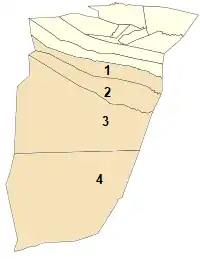
During the administrative breakdown of 2015, the delegated wilaya of El Menia is made up of 4 communes and 2 Districts:
- 1- Mansoura
- 2- Hassi Fehal
- 3- El Menia
- 4- Hassi Gara
References
- Office National des Statistiques, Recensement General de la Population et de l’Habitat 2008 Archived July 24, 2008, at the Wayback Machine Preliminary results of the 2008 population census. Accessed on July 2, 2008.
Places adjacent to El Menia Province | ||||||||||
|---|---|---|---|---|---|---|---|---|---|---|
| ||||||||||
| Flag of Algeria | |
This article is issued from Wikipedia. The text is licensed under Creative Commons - Attribution - Sharealike. Additional terms may apply for the media files.
