Elm Creek, Nebraska
Elm Creek is a village in Buffalo County, Nebraska, United States. It is part of the Kearney, Nebraska Micropolitan Statistical Area. The population was 901 at the 2010 census.
Elm Creek, Nebraska | |
|---|---|
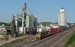 The Union Pacific Railroad's main line runs through Elm Creek. | |
 Location of Elm Creek, Nebraska | |
| Coordinates: 40°43′7″N 99°22′31″W | |
| Country | United States |
| State | Nebraska |
| County | Buffalo |
| Area | |
| • Total | 0.69 sq mi (1.80 km2) |
| • Land | 0.69 sq mi (1.80 km2) |
| • Water | 0.00 sq mi (0.00 km2) |
| Elevation | 2,267 ft (691 m) |
| Population | |
| • Total | 901 |
| • Estimate (2019)[3] | 949 |
| • Density | 1,365.47/sq mi (526.88/km2) |
| Time zone | UTC-6 (Central (CST)) |
| • Summer (DST) | UTC-5 (CDT) |
| ZIP code | 68836 |
| Area code(s) | 308 |
| FIPS code | 31-15360[4] |
| GNIS feature ID | 0829073[5] |
History
Elm Creek was founded circa 1870.[6] Prior to the arrival of the Union Pacific Railroad, the area was heavily timbered with ash, elm, and cottonwood trees but they were almost all removed for use in building the railroad.[7]
Geography
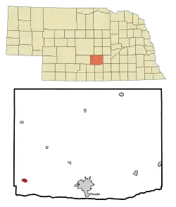
Elm Creek is located at 40°43′7″N 99°22′31″W (40.718630, -99.375330).[8]
According to the United States Census Bureau, the village has a total area of 0.70 square miles (1.81 km2), all land.[9]
Demographics
| Historical population | |||
|---|---|---|---|
| Census | Pop. | %± | |
| 1890 | 357 | — | |
| 1900 | 301 | −15.7% | |
| 1910 | 620 | 106.0% | |
| 1920 | 600 | −3.2% | |
| 1930 | 708 | 18.0% | |
| 1940 | 730 | 3.1% | |
| 1950 | 799 | 9.5% | |
| 1960 | 778 | −2.6% | |
| 1970 | 798 | 2.6% | |
| 1980 | 862 | 8.0% | |
| 1990 | 852 | −1.2% | |
| 2000 | 894 | 4.9% | |
| 2010 | 901 | 0.8% | |
| 2019 (est.) | 949 | [3] | 5.3% |
| U.S. Decennial Census[10] | |||
2010 census
As of the census[2] of 2010, there were 901 people, 373 households, and 243 families living in the village. The population density was 1,287.1 inhabitants per square mile (497.0/km2). There were 409 housing units at an average density of 584.3 per square mile (225.6/km2). The racial makeup of the village was 98.9% White, 0.1% Native American, 0.3% from other races, and 0.7% from two or more races. Hispanic or Latino people of any race were 4.1% of the population.
There were 373 households, of which 34.6% had children under the age of 18 living with them, 48.3% were married couples living together, 9.7% had a female householder with no husband present, 7.2% had a male householder with no wife present, and 34.9% were non-families. 29.2% of all households were made up of individuals, and 13.2% had someone living alone who was 65 years of age or older. The average household size was 2.42 and the average family size was 2.94.
The median age in the village was 36.2 years. 27.3% of residents were under the age of 18; 7.4% were between the ages of 18 and 24; 26.2% were from 25 to 44; 25.7% were from 45 to 64; and 13.4% were 65 years of age or older. The gender makeup of the village was 48.5% male and 51.5% female.
2000 census
As of the census[4] of 2000, there were 894 people, 363 households, and 231 families living in the village. The population density was 1,290.6 people per square mile (500.3/km2). There were 387 housing units at an average density of 558.7 per square mile (216.6/km2). The racial makeup of the village was 97.54% White, 0.11% Native American, 1.45% from other races, and 0.89% from two or more races. Hispanic or Latino people of any race were 3.02% of the population.
There were 363 households, out of which 34.4% had children under the age of 18 living with them, 54.5% were married couples living together, 6.3% had a female householder with no husband present, and 36.1% were non-families. 32.2% of all households were made up of individuals, and 14.6% had someone living alone who was 65 years of age or older. The average household size was 2.46 and the average family size was 3.14.
In the village, the population was spread out, with 30.1% under the age of 18, 6.4% from 18 to 24, 30.8% from 25 to 44, 20.9% from 45 to 64, and 11.9% who were 65 years of age or older. The median age was 34 years. For every 100 females, there were 96.9 males. For every 100 females age 18 and over, there were 96.5 males.
As of 2000 the median income for a household in the village was $32,279, and the median income for a family was $40,417. Males had a median income of $27,500 versus $19,688 for females. The per capita income for the village was $17,339. About 7.0% of families and 6.6% of the population were below the poverty line, including 5.0% of those under age 18 and 4.3% of those age 65 or over.
Notable people
References
- "2019 U.S. Gazetteer Files". United States Census Bureau. Retrieved July 26, 2020.
- "U.S. Census website". United States Census Bureau. Retrieved 2012-06-24.
- "Population and Housing Unit Estimates". United States Census Bureau. May 24, 2020. Retrieved May 27, 2020.
- "U.S. Census website". United States Census Bureau. Retrieved 2008-01-31.
- "US Board on Geographic Names". United States Geological Survey. 2007-10-25. Retrieved 2008-01-31.
- Burr, George L. (1921). History of Hamilton and Clay Counties, Nebraska, Volume 1. S.J. Clarke Publishing Company. p. 100.
- Bowman, J. R. (1882). Shearer, Frederick E. (ed.). The Pacific tourist. J.R. Bowman's illustrated transcontinental guide of travel from the Atlantic to the Pacific Ocean. New York: J.R. Bowman. p. 34. OCLC 752667534. Retrieved 15 May 2018.
- "US Gazetteer files: 2010, 2000, and 1990". United States Census Bureau. 2011-02-12. Retrieved 2011-04-23.
- "US Gazetteer files 2010". United States Census Bureau. Archived from the original on 2012-01-25. Retrieved 2012-06-24.
- "Census of Population and Housing". Census.gov. Retrieved June 4, 2015.
Municipalities and communities of Buffalo County, Nebraska, United States | ||
|---|---|---|
| Cities | Map of Nebraska highlighting Buffalo County | |
| Villages | ||
| CDPs | ||
| Other unincorporated communities | ||
| Townships | ||
| Footnotes | ‡This populated place also has portions in an adjacent county or counties | |
| ||