Kearney, Nebraska
Kearney /ˈkɑːrni/[6] is a city in and the county seat of Buffalo County, Nebraska, United States.[7] The population was 30,787 at the 2010 census.[8] It is home to the University of Nebraska at Kearney. The westward push of the railroad as the Civil War ended gave birth to the community.[9]
Kearney, Nebraska | |
|---|---|
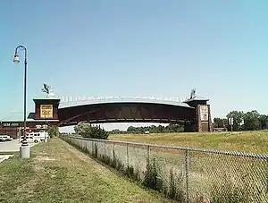 The Great Platte River Road Archway Monument, which spans Interstate 80 | |
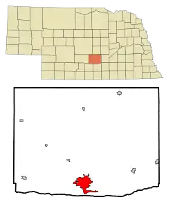 Location of Kearney within Nebraska and Buffalo County | |
| Coordinates: 40°42′3″N 99°4′52″W | |
| Country | United States |
| State | Nebraska |
| County | Buffalo |
| Government | |
| • Type | Council–manager[1] |
| • Mayor | Stan Clouse |
| Area | |
| • Total | 14.73 sq mi (38.16 km2) |
| • Land | 14.46 sq mi (37.44 km2) |
| • Water | 0.28 sq mi (0.72 km2) |
| Elevation | 2,152 ft (656 m) |
| Population | |
| • Total | 30,787 |
| • Estimate (2019)[4] | 33,867 |
| • Density | 2,342.60/sq mi (904.49/km2) |
| Time zone | UTC−6 (Central (CST)) |
| • Summer (DST) | UTC−5 (CDT) |
| ZIP codes | 68845, 68847, 68848 (P.O. Box), 68849 UNK |
| Area code(s) | 308 |
| FIPS code | 31-25055 |
| GNIS feature ID | 0830442[5] |
| Website | www |
Geography
Kearney is located at 40°42′3″N 99°4′52″W (40.700731, -99.081150).[10][11] Strategically located on I-80 with convenient access to the major markets of Omaha-Lincoln, Denver, Kansas City, Des Moines, Wichita and Cheyenne, Kearney is at the center of a seven-state region and 20 million people.[12]
According to the United States Census Bureau, the city has a total area of 13.00 square miles (33.67 km2), of which 12.77 square miles (33.07 km2) is land and 0.23 square miles (0.60 km2) is water.[13]
Demographics
| Historical population | |||
|---|---|---|---|
| Census | Pop. | %± | |
| 1880 | 1,782 | — | |
| 1890 | 8,074 | 353.1% | |
| 1900 | 5,634 | −30.2% | |
| 1910 | 6,202 | 10.1% | |
| 1920 | 7,702 | 24.2% | |
| 1930 | 8,575 | 11.3% | |
| 1940 | 9,643 | 12.5% | |
| 1950 | 12,115 | 25.6% | |
| 1960 | 14,210 | 17.3% | |
| 1970 | 19,181 | 35.0% | |
| 1980 | 21,158 | 10.3% | |
| 1990 | 24,396 | 15.3% | |
| 2000 | 27,431 | 12.4% | |
| 2010 | 30,787 | 12.2% | |
| 2019 (est.) | 33,867 | [4] | 10.0% |
| U.S. Decennial Census[14] 2018 Estimate[15] | |||
Kearney is the principal city of the Kearney, Nebraska Micropolitan Statistical Area, which consists of Buffalo and Kearney counties.
2010 census
As of the census[3] of 2010, there were 30,787 people, 12,201 households, and 7,015 families residing in the city. The population density was 2,410.9 inhabitants per square mile (930.9/km2). There were 12,738 housing units at an average density of 997.5 per square mile (385.1/km2). The racial makeup of the city was 92.3% White, 1.0% African American, 0.3% Native American, 1.8% Asian, 3.1% from other races, and 1.4% from two or more races. Hispanic or Latino of any race were 7.3% of the population.
There were 12,201 households, of which 29.4% had children under the age of 18 living with them, 43.7% were married couples living together, 9.9% had a female householder with no husband present, 4.0% had a male householder with no wife present, and 42.5% were non-families. 30.4% of all households were made up of individuals, and 9% had someone living alone who was 65 years of age or older. The average household size was 2.36 and the average family size was 2.96.
The median age in the city was 29 years. 22.2% of residents were under the age of 18; 20.5% were between the ages of 18 and 24; 25.6% were from 25 to 44; 20.6% were from 45 to 64; and 11.1% were 65 years of age or older. The gender makeup of the city was 48.9% male and 51.1% female.
2000 census
As of the census of 2000, there were 29,952 people, 10,549 households, and 6,160 families residing in the city. The population density was 2,498.5 people per square mile (964.6/km2). There were 11,099 housing units at an average density of 1,010.9 per square mile (390.3/km2). The racial makeup of the city was 95.18% White, 0.63% African American, 0.38% Native American, 0.92% Asian, 0.04% Pacific Islander, 1.68% from other races, and 1.17% from two or more races. Hispanic or Latino of any race were 4.08% of the population.
There were 10,549 households, out of which 30.3% had children under the age of 18 living with them, 45.7% were married couples living together, 9.7% had a female householder with no husband present, and 41.6% were non-families. 28.7% of all households were made up of individuals, and 9.5% had someone living alone who was 65 years of age or older. The average household size was 2.37 and the average family size was 2.96.
In the city, the population was spread out, with 22.2% under the age of 18, 23.9% from 18 to 24, 26.2% from 25 to 44, 17.1% from 45 to 64, and 10.6% who were 65 years of age or older. The median age was 27 years. For every 100 females, there were 92.6 males. For every 100 females age 18 and over, there were 89.7 males.
The median income for a household in the city was $34,829, and the median income for a family was $46,650. Males had a median income of $30,150 versus $22,366 for females. The per capita income for the city was $17,713. About 7.4% of families and 13.4% of the population were below the poverty line, including 11.8% of those under age 18 and 8.9% of those age 65 or over.
History
The original settlement in the area was called Dobytown, located 2 miles (3.2 km) southeast of the present-day Kearney. Later the city was moved and renamed after the nearby Fort Kearny (with an extra "e" added, but pronounced the same), a United States Army outpost along the Oregon Trail in the middle of the 19th century. The fort was named after Colonel (later General) Stephen W. Kearny.[16] The "e" was added by mistake sometime afterwards by postmen who consistently misspelled the town name;[17] eventually it just stuck. The current location of the city is on the north side of the Platte River and steadily grew as a result of the influence of the railroad.
In 1912, a Catholic Diocese was centered here. This status was removed in 1917, with the creation of other dioceses.[18][19] In 1997, the city began to be used as a titular see by the Catholic Church.[20]
Government
The council-manager form is used in Kearney. The City Council makes legislative and policy-making decisions. There are five members elected citywide to serve four-year terms which are staggered. The council manager form of government was adopted in 1950. Michael W. Morgan currently serves as city manager.
The council appoints a city manager to implement policies, prepare a budget, appoints department heads, and recommends areas that the council needs to attend. There are five members elected citywide serving staggered four-year terms. One member of the City Council is chosen by the council to be Mayor. Stanley Clouse is the Mayor.[21][22]
Education
- Kearney Public Schools operates 3 preschools, 12 elementary schools, 2 middle schools, and Kearney High School[23]
- Zion Lutheran School
- Faith Christian School of Kearney
- Kearney West High School, at the Youth Rehabilitation and Treatment Center[24]
- Kearney Catholic High School
College
University
University of Nebraska at Kearney (UNK) is located in the city. The campus is a 235-acre (0.95 km2) residential campus with more than 37 buildings. It was founded in 1905 as Nebraska State Normal School at Kearney and became Nebraska State Teachers College in 1921. Between 1963 and 1991 the school was known as Kearney State College. The college's name was changed to University of Nebraska at Kearney in 1991 when it joined the University of Nebraska system.
Economy
Companies headquartered in Kearney include Citizens Telecommunications Company of Nebraska and Buckle.
Top employers
According to Buffalo County Economic Development,[25] the top non-manufacturing employers in the city are:
| # | Employer | # of Employees |
|---|---|---|
| 1 | Good Samaritan Hospital | 1,000+ |
| 2 | University of Nebraska at Kearney | 1,000+ |
| 3 | Kearney Regional Medical Center | 850+ |
| 4 | Kearney Public Schools | 750-1,000 |
| 5 | Buckle | 500-750 |
| 6 | Walmart | 500-750 |
| 7 | Cabela's | 250-500 |
| 8 | Cash-Wa | 250-500 |
| 9 | City of Kearney | 250-500 |
The top manufacturing employers are:
| # | Employer | # of Employees |
|---|---|---|
| 1 | Baldwin Filters | 750-1,000 |
| 2 | Eaton | 250-500 |
| 3 | West Pharmaceutical Services | 250-500 |
| 4 | Chief Industries | 100-250 |
| 5 | Marshall Engines | 100-250 |
| 5 | Morris Printing Group | 100-250 |
Transportation
The city operates Kearney Regional Airport[26] located east of the city. Commercial air service is available via United Express with twice-daily service to Denver International Airport, as well as a daily non-stop flight to O'Hare Airport in Chicago, IL.
Attractions
Kearney is home to several museums, many of which reflect its location on the California, Mormon, Oregon, and Pony Express trails, and the Lincoln Highway.
- The Great Platte River Road Archway Monument spans Interstate 80 at mile marker 274 and contains exhibits that trace the history of the Great Platte River Road from the Oregon Trail days to the present.[27] On December 8, 2000, while on a visit to Kearney, President Bill Clinton toured the Great Platte River Road Archway Monument.[28] Jack Nicholson was filmed in a scene at the Archway for the movie About Schmidt.[29]
- The Museum of Nebraska Art, the state's official art collection, houses artworks spanning 175 years, from the 19th century to the present.[30]
- The George W. Frank House is an 1890s historic mansion located at the University of Nebraska at Kearney. The Robert M. Merryman Performing Arts Center, located in the city's Central Elementary School, is a 750-seat theater completed in 2006.[31]
- The Trails & Rails Museum is home to many of the county's historic structures from the late 1800s-through the mid-1900s. Tours are available at bchs.us
- The 5,500 seat Viaero Event Center hosts concerts, events, and performances, and is home to the Tri-City Storm, a United States Hockey League team.[32]
- In 2013, the Shrine Bowl State High School All-Star Football Game was moved from Lincoln to Kearney.[33]
- Two microbreweries, Thunderhead Brewing and the Platte Valley Brewery, are located in downtown Kearney.[34]
- The Classic Car Collection is an automotive museum containing over 210 automobiles.[35]
Local media
- Newspaper
- Radio
Notable people
- Drew Anderson, MLB player
- Jon Bokenkamp, writer and producer
- Solomon Butcher, photographer of the Homestead era in Nebraska, lived in Kearney for about a decade, beginning in 1902
- Alexander H. Conner, politician
- Leslie Easterbrook, actress
- Tom Kropp, professional basketball player
- James A. Lake, evolutionary biologist
- Kyle Larson, NFL player
- Lorraine Langford, Nebraska politician
- Stephen R. Lawhead, author
- Brett Maher, NFL player
- David Martin, congressman
- Andy Pessoa, actor
- Peter George Peterson, U.S. Secretary of Commerce 1972–73, co-founder of the Blackstone Group
- Ryan Quincy, Emmy winning Animator, Producer, and Voice Actor
- Tim Schlattmann, screenwriter
- Kathy Lou Schultz, poet and scholar
- Charlie Tuna, radio personality,
- Elizabeth T. Uldall, linguist
- Chuck Welch, artist
- Don Welch, American poet and academic, professor at the University of Nebraska at Kearney
- Dale E. Wolf, businessman and politician
Sports
- Kearney Yankees, 1956–1959, minor league baseball team affiliated with the New York Yankees
- Tri-City Storm, Tier I junior ice hockey team in the West Division of the United States Hockey League (USHL)
In popular culture
- Dexter (season 6), episode 7 ("Nebraska", airdate November 13, 2011) was set in Kearney, Nebraska, in large part because the show's co-executive producer, Tim Schlattmann, is a 1981 Kearney High School graduate.[36][37] In "Nebraska", whose departure in multiple ways from previous Dexter episodes was (for the most part) favorably received,[38] witness protection has relocated the Trinity Killer's surviving family to Kearney, where a copycat killer appears to have murdered Trinity's widow and daughter, so Dexter travels to Kearney to avenge the killings. Numerous elements in the episode underscore Kearney's rural setting and culture, some sinister, and farm-specific settings and implements add variety to Dexter's methods of killing and corpse disposal.[39]
Sister city
References
- "Government - City of Kearney, NE - Official Website". City of Kearney. Retrieved Dec 16, 2019.
- "2019 U.S. Gazetteer Files". United States Census Bureau. Retrieved July 26, 2020.
- "U.S. Census website". United States Census Bureau. Retrieved 2012-06-24.
- "Population and Housing Unit Estimates". United States Census Bureau. May 24, 2020. Retrieved May 27, 2020.
- "US Board on Geographic Names". United States Geological Survey. 2007-10-25. Retrieved 2008-01-31.
- "Nebraska Pronunciation Guide". Associated Press. Archived from the original on 2010-03-12. Retrieved 2010-01-28.
- "Find a County". National Association of Counties. Archived from the original on 2011-05-31. Retrieved 2011-06-07.
- http://www.kearneyhub.com/news/local/article_ec655b06-4e62-11e0-9533-001cc4c03286.html
- About Kearney, Kearney Visitors Bureau, Nebraska
- "US Gazetteer files: 2010, 2000, and 1990". United States Census Bureau. 2011-02-12. Retrieved 2011-04-23.
- Kearney Visitors Bureau
- Buffalo County Economic Development
- "US Gazetteer files 2010". United States Census Bureau. Archived from the original on 2012-07-02. Retrieved 2012-06-24.
- United States Census Bureau. "Census of Population and Housing". Retrieved June 22, 2013.
- "Population Estimates". United States Census Bureau. Retrieved June 8, 2018.
- Gannett, Henry (1905). The Origin of Certain Place Names in the United States. Govt. Print. Off. p. 172.
- Ellis, Mark (2006). Kearney. Arcadia Publishing. p. 7. ISBN 9780738541280.
- "Diocese of Grand Island". Catholic-Hierarchy. Retrieved 2013-06-04.
- "Diocese of Grand Island". Giga Catholic. Retrieved 2013-06-04.
- "Kearney (Titular See) [Catholic-Hierarchy]".
- http://www.cityofkearney.org/documents/Administration/Kearney%20Connection%20December%202008.PDF%5B%5D The Kearney Connection. Retrieved 2009-08-13.
- City of Kearney: Form of Government. Retrieved 2009-08-13.
- "District Snapshot" Archived 2011-07-26 at the Wayback Machine. Kearney Public Schools. Retrieved 2009-11-05.
- "About YRTC—Kearney". Nebraska Department of Health & Human Services. Archived from the original on 2011-07-18. Retrieved 2009-11-06.
- Community Profile Archived 2012-10-24 at the Wayback Machine Retrieved 2013-10-26
- "Airport | City of Kearney, NE - Official Website".
- "Archived copy". Archived from the original on 2011-12-10. Retrieved 2012-01-24.CS1 maint: archived copy as title (link)
- "Clinton to Visit Nebraska... Finally".
- http://www.roadsideamerica.com/story/9790
- "Archived copy". Archived from the original on 2011-12-10. Retrieved 2012-01-24.CS1 maint: archived copy as title (link)
- http://blog.kearneypublic.org/merryman/%5B%5D
- "Archived copy". Archived from the original on 2012-01-13. Retrieved 2012-01-24.CS1 maint: archived copy as title (link)
- http://www.kearneyhub.com/sports/local/shrine-bowl-coming-to-kearney/article_e51c5fb0-3084-11e2-8123-001a4bcf887a.html
- "Archived copy". Archived from the original on 2011-12-10. Retrieved 2012-01-24.CS1 maint: archived copy as title (link)
- "About Us". Classic Car Collection. Retrieved August 24, 2016.
- Schmidt, Kim (October 2, 2011). ""Dexter" producer, a Kearney native, says episode will be set in Nebraska". Lexch.com.
- Korbeik, Jeff (Sep 26, 2011). "In new season, 'Dexter' takes a closer look at its Nebraska roots". Lincoln Journal Star.
- Fowler, Matt (November 13, 2011). "Dexter: 'Nebraska' Review". IGN.
- Alston, Joshua (November 13, 2011). "Dexter: 'Nebraska'". AV Club.
External links
| Wikimedia Commons has media related to Kearney, Nebraska. |
- City of Kearney
- Kearney Hub, local newspaper
- Buffalo County Economic Development Council
- . Encyclopædia Britannica (11th ed.). 1911.
Municipalities and communities of Buffalo County, Nebraska, United States | ||
|---|---|---|
| Cities | Map of Nebraska highlighting Buffalo County | |
| Villages | ||
| CDPs | ||
| Other unincorporated communities | ||
| Townships | ||
| Footnotes | ‡This populated place also has portions in an adjacent county or counties | |
| ||
| Authority control |
|---|