Ensenada Municipality
The municipality (Spanish: municipio) of Ensenada, with a land area of 52,482.40 km2 (20,263.57 sq mi) prior to San Quintín Municipality's secession from the municipality, is the one of the largest municipality in Mexico by area. The municipality previously took up 72.6% of the land area of Baja California but was home to only 14.7% of the population. It shares borders with Baja California's four other municipalities to the north and northeast as well as with San Quintín Municipality to the south. Its municipal seat (Spanish: cabecera municipal) is Ensenada, which lies near the northwest corner of the municipality.
Ensenada Municipality
Municipio de Ensenada | |
|---|---|
| Municipality of Ensenada | |
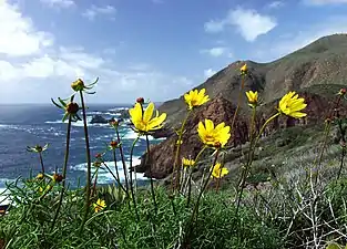 The Pacific coast of Ensenada Municipality | |
 Coat of arms | |
 Location of Ensenada in Baja California | |
| Coordinates: 30°N 115.5°W | |
| Country | |
| State | |
| Municipal seat | Ensenada |
| Largest city | Ensenada |
| Municipality established | December 29, 1953[1] |
| Government | |
| • Municipal president | Armando Ayala Robles (MORENA) |
| Area | |
| • Total | 52,482.4 km2 (20,263.6 sq mi) |
| Population (2020) | |
| • Total | 443,807 |
| • Density | 8.5/km2 (22/sq mi) |
| Data source: [2] | |
| Time zone | UTC−8 (Northwest (US Pacific)) |
| • Summer (DST) | UTC−7 (Northwest) |
| INEGI code | 001 |
| Website | (in Spanish) Ayuntamiento de Ensenada |
| Source: Enciclopedia de los Municipios de México | |
Ensenada's current (as of 2020) municipal president (Spanish: presidente municipal) is Armando Ayala Robles. A major port is planned to be built in Punta Colonet, a largely uninhabited area 80 km (50 mi) south of the city of Ensenada. Located offshore, Guadalupe Island is part of the municipality, making Ensenada the westernmost municipality in Mexico.
In 2020 the municipality had a population of 443,807.[3]
In February 2020, San Quintin Municipality separated from the municipality of Ensenada, and became the Baja California's sixth municipality.
Subdivisions

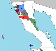
Territorially massive Ensenada municipality is administratively subdivided into 23 boroughs (Spanish: delegaciones), of which Ensenada is the municipal seat:
- La Mision - Borough seat: La Misión
- El Porvenir
- Francisco Zarco (Guadalupe)
- Real del Castillo
- El Sauzal
- Ensenada
- San Antonio de las Minas
- Maneadero
- Santo Tomás
- Erendira - Borough seat: Eréndira
- San Vicente
- Valle de la Trinidad
- Punta Colonet - Borough seat: Punta Colonet
- Puertecitos - Borough seat: Puertecitos
- Isla de Cedros
Demographics
| Year | Pop. | ±% |
|---|---|---|
| 2010 | 466,814 | — |
| 2015 | 486,639 | +4.2% |
| 2020 | 443,807 | −8.8% |
| [4][5][6][7] | ||
As of 2020, the municipality had a total population of 443,807.[8]
As of 2010, the city of Ensenada had a population of 279,765.[9] Other than the city of Ensenada, the municipality had 3,245 localities, the largest of which (with 2010 populations in parentheses) were:
Classified as urban:[9]
- Rodolfo Sánchez Taboada (Maneadero) (22,957)
- Lázaro Cárdenas (16,294)
- El Sauzal de Rodríguez (8,832)
- Benito García (El Zorrillo) (6,598)
- San Vicente (4,362)
- Real del Castillo Nuevo (Ojos Negros) (3,533)
- Lázaro Cárdenas (Valle de la Trinidad) (3,366)
- Ejido México (Punta Colonet) (3,278)
- Rancho Verde (2,758)
- Francisco Zarco (Valle de Guadalupe) (2,664)
Classified as rural:[9]
- Luis Rodríguez (El Vergel) (2,281)
- Colonia Benito Juárez (1,933)
- Ejido Profesor Graciano Sánchez (1,856)
- El Rosario de Arriba (1,704)
- Salvador Rosas Magallón (1,520)
- Ejido Eréndira (1,461)
- Poblado Chulavista (El Chorizo) (1,442)
- El Porvenir (Valle de Guadalupe) (1,416)
- Licenciado Gustavo Díaz Ordaz (1,394)
- Colonia Gómez Morín (1,362)
- Isla de Cedros (1,339)
- Poblado Héroes de Chapultepec (1,260)
- Santa María (Los Pinos) (1,255)
- La Providencia (1,253)
- Ejido General Leandro Valle (1,174)
- Ejido Francisco Villa (San Simón) (1,151)
- Las Brisas (1,078)
- Fraccionamiento del Valle (1,052)
- Pueblo Benito García (1,028)
See also
- Additional Information
- Punta Colonet, Baja California
- Maneadero
Notes
- (in Spanish) pp. 78–79, La Transformación de Baja California en Estado, 1931–1952 Archived 2011-09-29 at the Wayback Machine, Lawrence Douglas Taylor Hansen, Estudios Fronterizos, 1, #1 (January–June 2000), UABC, Mexicali, pp. 47–87.
- https://www.inegi.org.mx/app/areasgeograficas/#tabMCcollapse-Indicadores
- https://www.inegi.org.mx/app/areasgeograficas/#tabMCcollapse-Indicadores
- "Localidades y su población por municipio según tamaño de localidad" (PDF) (in Spanish). INEGI. Archived from the original (PDF) on August 31, 2018. Retrieved July 15, 2017.
- "Número de habitantes". INEGI (National Institute of Statistics and Geography). Archived from the original on July 2, 2017. Retrieved July 15, 2017.
- "Tabulados de la Encuesta Intercensal 2015" (xls) (in Spanish). INEGI. Archived from the original on December 31, 2017. Retrieved July 15, 2017.
- "INEGI. Censo de Población y Vivienda 2020. Tabulados del Cuestionario Básico – Aguascalientes" [INEGI. 2020 Population and Housing Census. Basic Questionnaire Tabulations – Aguascalientes] (Excel) (in Spanish). INEGI. 2020. pp. 1–4. Archived from the original on 28 January 2021. Retrieved 27 January 2021.
- https://www.inegi.org.mx/app/areasgeograficas/#tabMCcollapse-Indicadores
- "Ensenada". Catálogo de Localidades. Secretaría de Desarrollo Social (SEDESOL). Retrieved 23 April 2014.
References
- Ensenada: Its background, founding, and early development http://www.sandiegohistory.org/journal/84winter/ensenada.htm
- (in Spanish) Link to tables of population data from Census of 2005 INEGI: Instituto Nacional de Estadística, Geografía e Informática
- (in Spanish) Los Municipios con Mayor y Menor Extensión Territorial Instituto Nacional para el Federalismo y el Desarrollo Municipal
- (in Spanish) Subdivisions (delegaciones)
External links
| Wikimedia Commons has media related to Ensenada Municipality. |
- (in Spanish) Ayuntamiento de Ensenada Official government website.
- (in English) Property frenzy in Baja California, Diane Lindquist, San Diego Union-Tribune, April 24, 2006. Article on planned port construction at Punta Colonet.
Places adjacent to Ensenada Municipality | |
|---|---|
Mexicali (capital) | ||
| Topics | 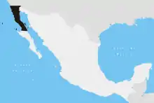 | |
| Major cities | ||
| Regions |
| |
| Metro areas | ||
| Municipalities | ||
| ||