Tecate Municipality
Tecate is a municipality in the Mexican state of Baja California. Its municipal seat is located in the city of Tecate. According to the 2020 census, it had a population of 108,440 inhabitants.[3] The municipality has an area of 3,079.0 km² (1,188.8 sq mi).
Tecate Municipality
Municipio de Tecate | |
|---|---|
 Coat of arms | |
| Motto(s): Paraíso Industrial de B.C. (English: Baja California's Industrial Paradise) | |
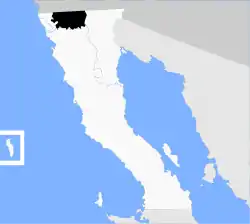 Location of Tecate in Baja California. | |
| Coordinates: 32°34′N 116°38′W | |
| Country | Mexico |
| State | Baja California |
| Municipal seat | Tecate |
| Largest city | Tecate |
| Municipality established | December 29, 1953[1] |
| Government | |
| • Municipal president | Cesar Rafael Moreno Gonzalez (PRI) |
| Area | |
| • Total | 3,079.0 km2 (1,188.8 sq mi) |
| Population (2020) | |
| • Total | 108,440 |
| • Density | 35/km2 (91/sq mi) |
| Data source: [2] | |
| Time zone | UTC−8 (Northwest (US Pacific)) |
| • Summer (DST) | UTC−7 (Northwest) |
| INEGI code | 003 |
| Website | (in Spanish) Gobierno Municipal de Tecate, Baja California |
| Source: Enciclopedia de los Municipios de México | |
Boroughs
The municipality is administratively subdivided into 6 boroughs, in addition to the municipal seat, Tecate.
- Nueva Colonia Hindú
- Colonia Luis Echeverría
- Heroes del Desierto
- Mi Ranchito
- Valle de Las Palmas
- La Rumorosa
Demographics
| Year | Pop. | ±% |
|---|---|---|
| 2010 | 101,079 | — |
| 2015 | 102,406 | +1.3% |
| 2020 | 108,440 | +5.9% |
| [4][5][6][7] | ||
As of 2020, the municipality had a total population of 108,440.[8]
As of 2010, the city of Tecate had a population of 64,764.[9] Other than the city of Tecate, the municipality had 964 localities, the largest of which (with 2010 populations in parentheses) were: Lomas de Santa Anita (6,604), Nueva Colonia Hindú (4,431), classified as urban, and Cereso del Hongo (4,278), Luis Echeverría Álvarez (El Hongo) (2,411), classified as urban, and Hacienda Tecate (1,871), Valle de las Palmas (1,860), La Rumorosa (1,836), Maclovio Herrera (Colonia Aviación) (1,219), Alfonso Garzón (Granjas Familiares) (1,188), and El Mirador (1,171), classified as rural.[9]
Adjacent municipalities and counties
- Mexicali Municipality - east
- Ensenada Municipality - south
- Tijuana Municipality - west
- San Diego County, California - north
- Imperial County, California - northeast
References
- (in Spanish) pp. 78–79, La Transformación de Baja California en Estado, 1931–1952 Archived 2011-09-29 at the Wayback Machine, Lawrence Douglas Taylor Hansen, Estudios Fronterizos, 1, #1 (Jan-June 2000), UABC, Mexicali, pp. 47–87.
- https://www.inegi.org.mx/app/areasgeograficas/#tabMCcollapse-Indicadores
- https://www.inegi.org.mx/app/areasgeograficas/#tabMCcollapse-Indicadores
- "Localidades y su población por municipio según tamaño de localidad" (PDF) (in Spanish). INEGI. Archived from the original (PDF) on August 31, 2018. Retrieved July 15, 2017.
- "Número de habitantes". INEGI (National Institute of Statistics and Geography). Archived from the original on July 2, 2017. Retrieved July 15, 2017.
- "Tabulados de la Encuesta Intercensal 2015" (xls) (in Spanish). INEGI. Archived from the original on December 31, 2017. Retrieved July 15, 2017.
- "INEGI. Censo de Población y Vivienda 2020. Tabulados del Cuestionario Básico – Aguascalientes" [INEGI. 2020 Population and Housing Census. Basic Questionnaire Tabulations – Aguascalientes] (Excel) (in Spanish). INEGI. 2020. pp. 1–4. Archived from the original on 28 January 2021. Retrieved 27 January 2021.
- https://www.inegi.org.mx/app/areasgeograficas/#tabMCcollapse-Indicadores
- "Tecate". Catálogo de Localidades. Secretaría de Desarrollo Social (SEDESOL). Retrieved 23 April 2014.
- (in Spanish) Link to tables of population data from 2010 Census, INEGI: Instituto Nacional de Estadística, Geografía e Informática.
- (in Spanish) Tecate, Enciclopedia de los Municipios de México, Instituto Nacional Para el Federalismo y el Desarrollo Municipal, SEGOB. Accessed on line November 15, 2007.
External links
- (in Spanish) Gobierno Municipal de Tecate, Baja California Official government website.
Places adjacent to Tecate Municipality | |
|---|---|
Mexicali (capital) | ||
| Topics |  | |
| Major cities | ||
| Regions |
| |
| Metro areas | ||
| Municipalities | ||
| ||
| Counties and Municipalities |  | |
|---|---|---|
| Major cities | ||
| Cities 100k - 250k | ||
| Cities and towns 20k - 99k | ||
| Cities and towns 10k-19k | ||
| Bodies of water | ||
| Sub-regions | ||
| ||