Rosarito Beach Municipality
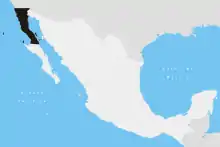
Playas de Rosarito Municipality (Spanish: Municipio de Playas de Rosarito) is located in the northwestern part of the Mexican state of Baja California comprising part of the Tijuana metropolitan area. It lies just south of the city of Tijuana. Its municipal seat is the city of Rosarito. According to the 2020 census, the municipality had a population of 126,890 inhabitants.[2] Its area is 513.32 km² (198.19 sq mi).
Playas de Rosarito Municipality | |
|---|---|
| Municipio de Playas de Rosarito | |
 Seal | |
| Motto(s): Un horizonte de posiblidades (A Horizon of Possibilities) | |
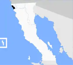 Location of Rosarito Beach Municipality in Baja California. | |
| Coordinates: 32°20′32″N 117°03′22″W | |
| Country | |
| State | |
| Municipal seat | Rosarito |
| Largest city | Rosarito |
| Municipality established | June 29, 1995 |
| Government | |
| • Municipal president | Hugo Torres ( |
| Area | |
| • Total | 513.32 km2 (198.19 sq mi) |
| Population (2020) | |
| • Total | 126,890 |
| • Density | 250/km2 (640/sq mi) |
| Data source: [1] | |
| Time zone | UTC−8 (PST) |
| • Summer (DST) | UTC−7 (PDT) |
| INEGI code | 005 |
| Website | (in Spanish) Ayuntamiento de Playas de Rosarito |
| Source: Enciclopedia de los Municipios de México | |
Name
Playas de Rosarito means "beaches of Rosarito".
Boroughs
- Primo Tapia
- Plan Libertador
Demographics
| Year | Pop. | ±% |
|---|---|---|
| 2010 | 90,668 | — |
| 2015 | 96,734 | +6.7% |
| 2020 | 126,890 | +31.2% |
| [3][4][5][6] | ||
As of 2020, the municipality had a total population of 126,890.[7]
As of 2010, the city of Playas de Rosarito had a population of 65,278.[8] Other than the city of Playas de Rosarito, the municipality had 358 localities, the largest of which (with 2010 populations in parentheses) were: Ampliación Ejido Plan Libertador (5,906), Primo Tapia (4,921), classified as urban, and Ciudad Morelos (2,040), Colinas del Sol (1,361), and Santa Anita (1,284), classified as rural.[8]
Other localities [8]
- El Descanso (pop. 567)
- Puerto Nuevo (pop. 135)
- Santa Anita (pop. 1,284)
References
- (in Spanish) Link to tables of population data from the 2005 Census, INEGI: Instituto Nacional de Estadística, Geografía e Informática.
- (in Spanish) Playas de Rosarito, Enciclopedia de los Municipios de México, Instituto Nacional Para el Federalismo y el Desarrollo Municipal, SEGOB. Accessed on line November 15, 2007.
- https://www.inegi.org.mx/app/areasgeograficas/#tabMCcollapse-Indicadores
- https://www.inegi.org.mx/app/areasgeograficas/#tabMCcollapse-Indicadores
- "Localidades y su población por municipio según tamaño de localidad" (PDF) (in Spanish). INEGI. Archived from the original (PDF) on August 31, 2018. Retrieved July 15, 2017.
- "Número de habitantes". INEGI (National Institute of Statistics and Geography). Archived from the original on July 2, 2017. Retrieved July 15, 2017.
- "Tabulados de la Encuesta Intercensal 2015" (xls) (in Spanish). INEGI. Archived from the original on December 31, 2017. Retrieved July 15, 2017.
- "INEGI. Censo de Población y Vivienda 2020. Tabulados del Cuestionario Básico – Aguascalientes" [INEGI. 2020 Population and Housing Census. Basic Questionnaire Tabulations – Aguascalientes] (Excel) (in Spanish). INEGI. 2020. pp. 1–4. Archived from the original on 28 January 2021. Retrieved 27 January 2021.
- https://www.inegi.org.mx/app/areasgeograficas/#tabMCcollapse-Indicadores
- "Playas de Rosarito". Catálogo de Localidades. Secretaría de Desarrollo Social (SEDESOL). Retrieved 23 April 2014.
External links
- (in Spanish) Ayuntamiento de Playas de Rosarito Official government website.
- (in English) Official government tourism office website
Articles relating to Rosarito Beach Municipality | |||||||||||||||||||||||||||||||||||||||||||||
|---|---|---|---|---|---|---|---|---|---|---|---|---|---|---|---|---|---|---|---|---|---|---|---|---|---|---|---|---|---|---|---|---|---|---|---|---|---|---|---|---|---|---|---|---|---|
| |||||||||||||||||||||||||||||||||||||||||||||
Places adjacent to Rosarito Beach Municipality | ||||||||||
|---|---|---|---|---|---|---|---|---|---|---|
| ||||||||||