Eupora, Mississippi
Eupora is the largest city in Webster County, central Mississippi. The population was 2,197 at the 2010 census.
Eupora, Mississippi | |
|---|---|
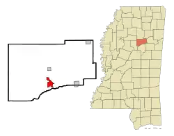 Location of Eupora, Mississippi | |
 Eupora, Mississippi Location in the United States | |
| Coordinates: 33°32′30″N 89°16′20″W | |
| Country | United States |
| State | Mississippi |
| County | Webster |
| Area | |
| • Total | 3.68 sq mi (9.54 km2) |
| • Land | 3.36 sq mi (8.69 km2) |
| • Water | 0.33 sq mi (0.85 km2) |
| Elevation | 384 ft (117 m) |
| Population | |
| • Total | 2,197 |
| • Estimate (2019)[3] | 2,005 |
| • Density | 597.44/sq mi (230.65/km2) |
| Time zone | UTC-6 (Central (CST)) |
| • Summer (DST) | UTC-5 (CDT) |
| ZIP code | 39744 |
| Area code(s) | 662 |
| FIPS code | 28-23420 |
| GNIS feature ID | 0669823 |
History
Eupora was established in 1889 by European Americans on a spur track of the Georgia Pacific Railway. While there had been agricultural development prior to this in the county, the railroad stimulated trade and businesses. Today this is the largest city in the county.
Near here was a site in 1770 of armed conflict among some Native American tribes. The Chakchiuma were destroyed by the allied Choctaw and Chickasaw, who were traditional enemies in the region. They dominated territories in what became Mississippi and Alabama.[4]
Prior to construction of the railroad to the area, Webster County was developed for cotton plantations, with planters dependent on many enslaved African Americans for labor. After the Civil War, whites used violence and intimidation to suppress black voting and to establish white supremacy through custom and Jim Crow laws.
In 1904 Bud Simpson, an African-American man also known as Sterling (or Starling) Dunham, was accused of raping some white girls. Not given a trial, he was lynched - hanged from a tree by a mob of 200 cheering white people. They riddled his body with bullets.[5]
Geography
According to the United States Census Bureau, the city has a total area of 3.6 square miles (9.3 km2), of which 3.3 square miles (8.4 km2) is land and 0.3 square mile (0.8 km2) (8.94%) is water.
Demographics
| Historical population | |||
|---|---|---|---|
| Census | Pop. | %± | |
| 1890 | 432 | — | |
| 1900 | 724 | 67.6% | |
| 1910 | 896 | 23.8% | |
| 1920 | 948 | 5.8% | |
| 1930 | 1,092 | 15.2% | |
| 1940 | 1,377 | 26.1% | |
| 1950 | 1,338 | −2.8% | |
| 1960 | 1,468 | 9.7% | |
| 1970 | 1,792 | 22.1% | |
| 1980 | 2,048 | 14.3% | |
| 1990 | 2,145 | 4.7% | |
| 2000 | 2,326 | 8.4% | |
| 2010 | 2,197 | −5.5% | |
| 2019 (est.) | 2,005 | [3] | −8.7% |
| U.S. Decennial Census[6] | |||
As of the census[7] of 2000, there were 2,326 people, 877 households, and 590 families residing in the city. The population density was 714.2 people per square mile (275.5/km2). There were 957 housing units at an average density of 293.9 per square mile (113.3/km2). The racial makeup of the city was 58.86% White, 38.01% African American, 0.13% Native American, 0.17% Asian, 2.28% from other races, and 0.56% from two or more races. Hispanic or Latino of any race were 3.74% of the population.
There were 877 households, out of which 31.9% had children under the age of 18 living with them, 41.3% were married couples living together, 21.2% had a female householder with no husband present, and 32.7% were non-families. 30.4% of all households were made up of individuals, and 16.4% had someone living alone who was 65 years of age or older. The average household size was 2.47 and the average family size was 3.08.
In the city, the population was spread out, with 26.1% under the age of 18, 9.3% from 18 to 24, 24.5% from 25 to 44, 18.1% from 45 to 64, and 22.1% who were 65 years of age or older. The median age was 38 years. For every 100 females, there were 79.5 males. For every 100 females age 18 and over, there were 74.1 males.
The median income for a household in the city was $24,839, and the median income for a family was $37,950. Males had a median income of $26,875 versus $21,458 for females. The per capita income for the city was $12,927. About 20.9% of families and 24.0% of the population were below the poverty line, including 35.6% of those under age 18 and 16.9% of those age 65 or over.
Education
The City of Eupora is served by the Webster County School District. There are 2 elementary schools, 2 middle schools, 2 high schools, and a career and technical center.
Notable people
- Thomas Abernethy, former U.S. Congressman
- Johnie Hammond, Iowa state legislator
- Joseph Turner Patterson (D) - former Attorney General of Mississippi
- Marckell Patterson, professional basketball player
- Derrick Jones, professional football player.
- Donald C. Simmons, Jr., educator, author, poet and documentary film producer.[8][9][10]
References
- "2019 U.S. Gazetteer Files". United States Census Bureau. Retrieved July 26, 2020.
- "2010 City Population and Housing Occupancy Status". U.S. Census Bureau. Retrieved May 14, 2012.
- "Population and Housing Unit Estimates". United States Census Bureau. May 24, 2020. Retrieved May 27, 2020.
- "Welcome to Webster County". Retrieved 3 January 2018.
- "Webster Fiend Lynched". Starkville News. 8 July 1904. Retrieved 3 January 2018.
- "Census of Population and Housing". Census.gov. Retrieved June 4, 2015.
- "U.S. Census website". United States Census Bureau. Retrieved 2008-01-31.
- "Archived copy". Archived from the original on 2009-08-08. Retrieved 2010-06-29.CS1 maint: archived copy as title (link)
- "McFarland". Mcfarlandpub.com. Archived from the original on 2012-02-14. Retrieved 2017-05-02.
- https://www.ivpress.com/donald-c-simmons-jr. Missing or empty
|title=(help)
External links
Municipalities and communities of Webster County, Mississippi, United States | ||
|---|---|---|
| City | 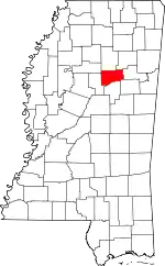 Map of Mississippi highlighting Webster County | |
| Towns | ||
| Villages | ||
| Unincorporated communities | ||
| Footnotes | ‡This populated place also has portions in an adjacent county or counties | |
| ||
| Authority control |
|---|
