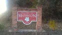
Mathiston, Mississippi
Mathiston is a town in Choctaw and Webster counties, Mississippi. The population was 698 at the 2010 census.
Mathiston, Mississippi | |
|---|---|
 | |
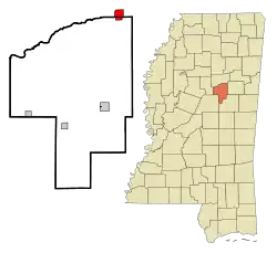 Location of Mathiston, Mississippi | |
 Mathiston, Mississippi Location in the United States | |
| Coordinates: 33°32′12″N 89°7′36″W | |
| Country | United States |
| State | Mississippi |
| Counties | Webster, Choctaw |
| Area | |
| • Total | 2.48 sq mi (6.43 km2) |
| • Land | 2.46 sq mi (6.38 km2) |
| • Water | 0.02 sq mi (0.05 km2) |
| Elevation | 420 ft (128 m) |
| Population | |
| • Total | 698 |
| • Estimate (2019)[3] | 664 |
| • Density | 269.37/sq mi (104.00/km2) |
| Time zone | UTC-6 (Central (CST)) |
| • Summer (DST) | UTC-5 (CDT) |
| ZIP code | 39752 |
| Area code(s) | 662 |
| FIPS code | 28-45720 |
| GNIS feature ID | 0673240 |
Geography
Mathiston is located at 33°32′12″N 89°7′36″W (33.536549, -89.126529).[4] Most of the town is in Webster County with a portion on the south side extending into Choctaw County.[5] In the 2000 census, 643 of the town's 720 residents (89.3%) lived in Webster County and 77 (10.7%) in Choctaw County.[6]
According to the United States Census Bureau, the town has a total area of 2.5 square miles (6.4 km2), all land.
Demographics
| Historical population | |||
|---|---|---|---|
| Census | Pop. | %± | |
| 1900 | 170 | — | |
| 1910 | 576 | 238.8% | |
| 1920 | 463 | −19.6% | |
| 1930 | 484 | 4.5% | |
| 1940 | 549 | 13.4% | |
| 1950 | 584 | 6.4% | |
| 1960 | 597 | 2.2% | |
| 1970 | 570 | −4.5% | |
| 1980 | 632 | 10.9% | |
| 1990 | 818 | 29.4% | |
| 2000 | 720 | −12.0% | |
| 2010 | 698 | −3.1% | |
| 2019 (est.) | 664 | [3] | −4.9% |
| U.S. Decennial Census[7] | |||
As of the census[8] of 2000, there were 720 people, 294 households, and 194 families residing in the town. The population density was 289.7 people per square mile (111.6/km2). There were 323 housing units at an average density of 130.0 per square mile (50.1/km2). The racial makeup of the town was 80.00% White, 18.33% African American, 0.69% Asian, 0.69% from other races, and 0.28% from two or more races. Hispanic or Latino of any race were 1.81% of the population.
There were 294 households, out of which 33.0% had children under the age of 18 living with them, 49.7% were married couples living together, 13.6% had a female householder with no husband present, and 33.7% were non-families. 32.0% of all households were made up of individuals, and 19.7% had someone living alone who was 65 years of age or older. The average household size was 2.45 and the average family size was 3.11.
In the town, the population was spread out, with 27.8% under the age of 18, 9.9% from 18 to 24, 24.3% from 25 to 44, 22.1% from 45 to 64, and 16.0% who were 65 years of age or older. The median age was 36 years. For every 100 females, there were 82.3 males. For every 100 females age 18 and over, there were 75.7 males.
The median income for a household in the town was $23,125, and the median income for a family was $28,889. Males had a median income of $27,875 versus $23,472 for females. The per capita income for the town was $12,222. About 21.4% of families and 25.2% of the population were below the poverty line, including 42.5% of those under age 18 and 25.2% of those age 65 or over.
Education
Most of Mathiston is served by the Webster County School District. The Choctaw County portion of Mathiston is served by the Choctaw County School District.
Woodland Seminary opened in Mathiston in 1886. It was renamed Bennett Academy in 1897, and then Wood College in 1936. It closed in 2003. The former campus is listed on the National Register of Historic Places.[9]
Government
The Mathiston Police Department frequently conducts roadblocks on the highways running through the town in the part located in Webster County to search for and seize any and all alcohol being transported through the county. While the legality of such roadblocks are not in dispute, the ability for the police to seize alcohol from persons over 21, provided containers are unopened, will be prohibited after July 1, 2018, following the passage of Mississippi House Bill 192, which legalizes transport of all alcohol through dry counties within the state.[10]
Climate
The climate in this area is characterized by hot, humid summers and generally mild to cool winters. According to the Köppen Climate Classification system, Mathiston has a humid subtropical climate, abbreviated "Cfa" on climate maps.[11]
References
- "2019 U.S. Gazetteer Files". United States Census Bureau. Retrieved July 26, 2020.
- "2010 City Population and Housing Occupancy Status". U.S. Census Bureau. Retrieved May 14, 2012.
- "Population and Housing Unit Estimates". United States Census Bureau. May 24, 2020. Retrieved May 27, 2020.
- "US Gazetteer files: 2010, 2000, and 1990". United States Census Bureau. 2011-02-12. Retrieved 2011-04-23.
- American FactFinder Reference Map Archived 2007-03-11 at the Wayback Machine
- "Subcounty population estimates: Mississippi 2000-2006". United States Census Bureau, Population Division. 2007-06-28. Archived from the original (CSV) on 2007-11-26. Retrieved 2007-07-21.
- "Census of Population and Housing". Census.gov. Retrieved June 4, 2015.
- "U.S. Census website". United States Census Bureau. Retrieved 2008-01-31.
- "Wood College". Millsaps College. Archived from the original on 2013-12-05. Retrieved July 22, 2014.
- http://billstatus.ls.state.ms.us/2018/pdf/history/HB/HB0192.xml
- Climate Summary for Mathiston, Mississippi
Municipalities and communities of Choctaw County, Mississippi, United States | ||
|---|---|---|
| Towns | 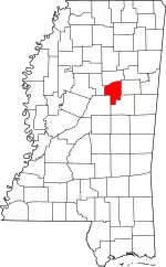 Map of Mississippi highlighting Choctaw County | |
| Unincorporated communities | ||
| Ghost towns | ||
| Footnotes | ‡This populated place also has portions in an adjacent county or counties | |
| ||
Municipalities and communities of Webster County, Mississippi, United States | ||
|---|---|---|
| City |  Map of Mississippi highlighting Webster County | |
| Towns | ||
| Villages | ||
| Unincorporated communities | ||
| Footnotes | ‡This populated place also has portions in an adjacent county or counties | |
| ||