Fair Oaks, Oregon
Fair Oaks is an unincorporated community and census-designated place in Douglas County, in the U.S. state of Oregon.[1] It lies at the south end of Driver Valley and along Calapooya Creek,[1] between Sutherlin and Nonpareil by road and upstream from Oakland along the creek.[2] As of the 2010 census, it had a population of 278.[3]
Fair Oaks, Oregon | |
|---|---|
Census-designated place (CDP) | |
 Fair Oaks, Oregon  Fair Oaks, Oregon | |
| Coordinates: 43°25′02″N 123°12′48″W | |
| Country | United States |
| State | Oregon |
| County | Douglas |
| Area | |
| • Total | 1.9 sq mi (4.8 km2) |
| • Land | 1.9 sq mi (4.8 km2) |
| • Water | 0 sq mi (0 km2) |
| Elevation | 633 ft (193 m) |
| Population (2010) | |
| • Total | 278 |
| • Density | 150/sq mi (58/km2) |
| Time zone | UTC-8 (Pacific (PST)) |
| • Summer (DST) | UTC-7 (PDT) |
| Area code(s) | 541 |
| GNIS feature ID | 1136275 |
| Coordinates and elevation from United States Geological Survey[1] | |
Fair Oaks was named for the oak trees in its vicinity. It had its own post office from 1878 through 1882, and thereafter Fair Oaks mail went via the post office at Oakland.[4]
References
- "Fair Oaks". Geographic Names Information System. United States Geological Survey. November 28, 1980. Retrieved December 15, 2014.
- Oregon Atlas & Gazetteer (7th ed.). Yarmouth, Maine: DeLorme. 2008. p. 53. ISBN 978-0-89933-347-2.
- "Profile of General Population and Housing Characteristics: 2010 Demographic Profile Data (DP-1): Fair Oaks CDP, Oregon". United States Census Bureau. Retrieved February 10, 2012.
- McArthur, Lewis A.; Lewis L. McArthur (2003) [1928]. Oregon Geographic Names (7th ed.). Portland, Oregon: Oregon Historical Society Press. p. 342. ISBN 0-87595-277-1.
Municipalities and communities of Douglas County, Oregon, United States | ||
|---|---|---|
| Cities | 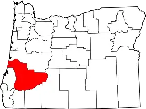 Douglas County map | |
| CDPs | ||
| Unincorporated communities | ||
| Indian reservations | ||
| Footnotes | ‡This populated place also has portions in an adjacent county or counties | |
| ||
This article is issued from Wikipedia. The text is licensed under Creative Commons - Attribution - Sharealike. Additional terms may apply for the media files.