Douglas County, Oregon
Douglas County is one of the 36 counties in the U.S. state of Oregon. As of the 2010 census, the population was 107,667.[1] The county seat is Roseburg.[2] It is named after Stephen A. Douglas, an American politician who supported Oregon statehood. Douglas County comprises the Roseburg, OR Micropolitan Statistical Area.
Douglas County | |
|---|---|
_(douDA0066).jpg.webp) Douglas County Courthouse in Roseburg | |
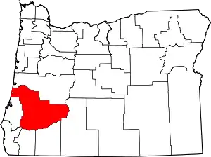 Location within the U.S. state of Oregon | |
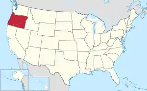 Oregon's location within the U.S. | |
| Coordinates: 43°17′N 123°11′W | |
| Country | |
| State | |
| Founded | January 7, 1852 |
| Seat | Roseburg |
| Largest city | Roseburg |
| Area | |
| • Total | 5,134 sq mi (13,300 km2) |
| • Land | 5,036 sq mi (13,040 km2) |
| • Water | 98 sq mi (250 km2) 1.9%% |
| Population (2010) | |
| • Total | 107,667 |
| • Estimate (2019) | 110,980 |
| • Density | 21/sq mi (8/km2) |
| Time zone | UTC−8 (Pacific) |
| • Summer (DST) | UTC−7 (PDT) |
| Congressional district | 4th |
| Website | www |
History
The area originally was inhabited by the Umpqua Indians, who speak a language in the Athabaskan language family (although some linguists put it in the Penutian family). Following the Rogue River Indian War in 1856, most of the remaining natives were moved by the government to the Grand Ronde Indian Reservation. However, seven families of Umpqua hid in the hills, eluding capture for many decades. They are now federally recognized as the Cow Creek Band of Umpqua Tribe of Indians. The tribe manages a small reservation in Canyonville, Oregon, and has a Casino/Hotel named Seven Feathers to represent the seven families who refused forced removal to the Grand Ronde Reservation.
Douglas County was created on January 7, 1852, from the portion of Umpqua County which lay east of the Coast Range summit. In 1856 the Camas Valley was annexed to Douglas County from Coos County. In 1862, the rest of Umpqua county was absorbed into Douglas County, some say due to the loss of population following the end of the early gold boom, while others attribute the absorption to politics. Further boundary adjustments were made with Jackson and Lane Counties in 1915. The borders of Douglas County are largely defined by the Umpqua River watershed.
In 2017, after the defeat of a referendum, the Douglas County Library System ceased operations and all public libraries in the county were permanently closed.[3]
Geography
According to the U.S. Census Bureau, the county has a total area of 5,134 square miles (13,300 km2), of which 5,036 square miles (13,040 km2) is land and 98 square miles (250 km2) (1.9%) is water.[4] It is the fifth-largest county in Oregon by area. A portion of the Umpqua National Forest is in Douglas County. Douglas County is one of two Oregon counties that extend from the Pacific Ocean to the Cascade Range. (The other is Lane County.)
National protected areas
- Crater Lake National Park (part)
- Rogue River-Siskiyou National Forest (part)
- Siuslaw National Forest (part)
- Umpqua National Forest (part)
- Willamette National Forest (part)
Adjacent counties
- Lane County (north)
- Klamath County (east)
- Jackson County (south)
- Josephine County (south)
- Curry County (southwest)
- Coos County (west)
Demographics
| Historical population | |||
|---|---|---|---|
| Census | Pop. | %± | |
| 1860 | 3,203 | — | |
| 1870 | 6,066 | 89.4% | |
| 1880 | 9,596 | 58.2% | |
| 1890 | 11,864 | 23.6% | |
| 1900 | 14,565 | 22.8% | |
| 1910 | 19,674 | 35.1% | |
| 1920 | 21,332 | 8.4% | |
| 1930 | 21,965 | 3.0% | |
| 1940 | 25,728 | 17.1% | |
| 1950 | 54,549 | 112.0% | |
| 1960 | 68,458 | 25.5% | |
| 1970 | 71,743 | 4.8% | |
| 1980 | 93,748 | 30.7% | |
| 1990 | 94,649 | 1.0% | |
| 2000 | 100,399 | 6.1% | |
| 2010 | 107,667 | 7.2% | |
| 2019 (est.) | 110,980 | [5] | 3.1% |
| U.S. Decennial Census[6] 1790-1960[7] 1900-1990[8] 1990-2000[9] 2010-2019[1] | |||
2000 census
As of the census[10] of 2000, there were 100,399 people, 39,821 households, and 28,233 families living in the county. The population density was 20 people per square mile (8/km2). There were 43,284 housing units at an average density of 9 per square mile (3/km2). The racial makeup of the county was 93.86% White, 0.18% Black or African American, 1.52% Native American, 0.63% Asian, 0.09% Pacific Islander, 1.02% from other races, and 2.70% from two or more races. 3.27% of the population were Hispanic or Latino of any race. 18.4% were of German, 13.2% American, 12.6% English and 10.2% Irish ancestry. 96.5% spoke English and 2.2% Spanish as their first language.
There were 39,821 households, out of which 29.10% had children under the age of 18 living with them, 57.2% were married couples living together, 9.6% had a female householder with no husband present, and 29.1% were non-families. 23.9% of all households were made up of individuals, and 11% had someone living alone who was 65 years of age or older. The average household size was 2.48 and the average family size was 2.9.
In the county, the population was spread out, with 24% under the age of 18, 7.5% from 18 to 24, 24.2% from 25 to 44, 26.4% from 45 to 64, and 17.8% who were 65 years of age or older. The median age was 41 years. For every 100 females there were 96.8 males. For every 100 females age 18 and over, there were 94.2 males.
The median income for a household in the county was $33,223, and the median income for a family was $39,364. Males had a median income of $32,512 versus $22,349 for females. The per capita income for the county was $16,581. About 9.6% of families and 13.1% of the population were below the poverty line, including 16.6% of those under age 18 and 9.2% of those age 65 or over.
2010 census
As of the 2010 United States Census, there were 107,667 people, 44,581 households, and 29,839 families living in the county.[11] The population density was 21.4 inhabitants per square mile (8.3/km2). There were 48,915 housing units at an average density of 9.7 per square mile (3.7/km2).[12] The racial makeup of the county was 92.4% white, 1.8% American Indian, 1.0% Asian, 0.3% black or African American, 0.1% Pacific islander, 1.2% from other races, and 3.2% from two or more races. Those of Hispanic or Latino origin made up 4.7% of the population.[11] In terms of ancestry, 25.6% were German, 16.7% were Irish, 15.8% were English, and 5.7% were American.[13]
Of the 44,581 households, 26.4% had children under the age of 18 living with them, 51.2% were married couples living together, 10.8% had a female householder with no husband present, 33.1% were non-families, and 26.6% of all households were made up of individuals. The average household size was 2.38 and the average family size was 2.82. The median age was 46.1 years.[11]
The median income for a household in the county was $39,711 and the median income for a family was $48,729. Males had a median income of $39,308 versus $28,176 for females. The per capita income for the county was $21,342. About 10.6% of families and 15.6% of the population were below the poverty line, including 24.1% of those under age 18 and 9.0% of those age 65 or over.[14]
Communities
Cities
Census-designated places
Unincorporated communities
Politics
In contrast to the Willamette Valley, Douglas County is powerfully conservative and Republican, being akin to Josephine County to the south, or to Eastern Oregon. No Democratic presidential nominee has carried Douglas County since Lyndon Johnson’s landslide win in 1964: indeed the last Democrat to crack forty percent of the county’s vote was Michael Dukakis in 1988 during an election influenced by a major drought. Historically, the county, like all of Western Oregon north of the Rogue Valley, also leaned strongly Republican: before 1964 the only other Democrats to carry Douglas County had been John F. Kennedy in 1960, Franklin Delano Roosevelt in 1936 and 1932, Woodrow Wilson in 1912 and William Jennings Bryan in 1896.[15]
Douglas County lies within Oregon's 4th congressional district, which also includes the more liberal Eugene metropolitan area and has thus been represented by Democrat Peter A. DeFazio since 1987. Within the Oregon House of Representatives, Douglas County is split between four districts. The coastal part lies within the 9th District represented by Democrat Caddy McKeown, whilst a belt from Roseburg south lies in the 2nd District, which extends into Jackson and Josephine Counties and is represented by Republican Dallas Heard. The far southwest adjacent to Curry County lies in the 1st District represented by Republican David Brock Smith, and the bulk of the county, centered on the northeastern half, lies in the 7th District represented by Republican Cedric Ross Hayden.
In the Oregon State Senate, Douglas County is split between three districts. The coastal part (9th House of Representatives District) lies within the 5th Senate District represented by Democrat Arnie Roblan. The two southwestern State House Districts (1st and 2nd) are part of the 1st Senate District represented by Republican Jeff Kruse. The main body of the county in the 7th House of Representative District corresponds with the 4th Senate District centered upon Eugene and represented by Democrat Floyd Prozanski.
| Year | Republican | Democratic | Third parties |
|---|---|---|---|
| 2020 | 67.3% 43,298 | 29.8% 19,160 | 3.0% 1,891 |
| 2016 | 64.6% 34,582 | 26.3% 14,096 | 9.1% 4,843 |
| 2012 | 61.8% 30,776 | 34.4% 17,145 | 3.8% 1,882 |
| 2008 | 58.4% 30,919 | 38.3% 20,298 | 3.3% 1,720 |
| 2004 | 65.4% 35,956 | 32.9% 18,089 | 1.7% 939 |
| 2000 | 64.2% 30,294 | 30.1% 14,193 | 5.8% 2,733 |
| 1996 | 51.1% 21,855 | 35.7% 15,250 | 13.2% 5,664 |
| 1992 | 41.5% 19,011 | 30.8% 14,137 | 27.7% 12,712 |
| 1988 | 52.4% 20,120 | 44.9% 17,255 | 2.7% 1,040 |
| 1984 | 63.1% 25,243 | 36.5% 14,609 | 0.4% 144 |
| 1980 | 58.5% 23,101 | 31.8% 12,564 | 9.8% 3,851 |
| 1976 | 50.0% 16,500 | 45.4% 14,965 | 4.6% 1,508 |
| 1972 | 57.7% 15,881 | 32.8% 9,009 | 9.5% 2,618 |
| 1968 | 51.4% 13,410 | 35.2% 9,186 | 13.4% 3,496 |
| 1964 | 38.1% 9,806 | 61.9% 15,909 | 0.0% 2 |
| 1960 | 48.4% 12,493 | 51.6% 13,322 | |
| 1956 | 53.9% 13,837 | 46.1% 11,825 | |
| 1952 | 64.1% 14,109 | 35.6% 7,837 | 0.3% 63 |
| 1948 | 56.4% 7,671 | 40.4% 5,500 | 3.2% 441 |
| 1944 | 56.6% 6,134 | 42.1% 4,563 | 1.3% 143 |
| 1940 | 55.6% 5,991 | 43.7% 4,707 | 0.7% 72 |
| 1936 | 42.1% 4,254 | 48.4% 4,893 | 9.5% 963 |
| 1932 | 44.7% 4,046 | 51.2% 4,638 | 4.1% 370 |
| 1928 | 70.5% 5,609 | 27.6% 2,191 | 1.9% 154 |
| 1924 | 53.8% 4,219 | 21.2% 1,666 | 25.0% 1,964 |
| 1920 | 60.2% 4,402 | 33.2% 2,428 | 6.6% 485 |
| 1916 | 48.2% 3,922 | 45.2% 3,679 | 6.7% 542 |
| 1912 | 26.0% 1,267 | 32.9% 1,601 | 41.1% 1,998[lower-alpha 1] |
| 1908 | 53.8% 2,092 | 35.0% 1,359 | 11.2% 437 |
| 1904 | 63.2% 2,443 | 23.5% 908 | 13.3% 514 |
| 1900 | 51.9% 1,910 | 44.1% 1,624 | 3.9% 143 |
| 1896 | 47.7% 1,917 | 51.2% 2,059 | 1.1% 46 |
| 1892 | 44.3% 1,329 | 17.6% 529 | 38.1% 1,144 |
| 1888 | 51.7% 1,305 | 44.3% 1,117 | 4.0% 101 |
| 1884 | 51.2% 1,216 | 47.4% 1,125 | 1.4% 34 |
| 1880 | 52.8% 1,256 | 46.4% 1,105 | 0.8% 18 |
Economy
Almost the entire watershed of the Umpqua River lies within the boundaries of Douglas County. The heavily timbered county contains nearly 1.8 million acres (7,300 km2) of commercial forest lands and one of the oldest stands of old growth timber in the world. Approximately 25–30% of the labor force is employed in the forest products industry. Agriculture, mainly field crops, orchards, and livestock (particularly sheep ranching), is also important to the economy of the county. The land of Douglas County is roughly half-publicly and half-privately owned.[18]
The post-Prohibition wine industry in Oregon began with Richard Somer planting Hillcrest Vineyard at the south end of the Umpqua Valley in 1961. The Umpqua Valley wine appellation lies entirely within Douglas county.
Nickel has been refined at Riddle since 1954. There is a significant federal presence in the region; the Forest Service and Bureau of Land Management administer more than 50% of the county's land.
As of 2015, the top ten private employers in the county were:[19]
| # | Employer | # of Employees |
|---|---|---|
| 1 | Roseburg Forest Products | 1,885 |
| 2 | Mercy Medical Center | 1,092 |
| 3 | Swanson Group Aviation | 682 |
| 4 | TMS Call Center | 615 |
| 5 | Seven Feathers Hotel & Casino Resort | 606 |
| 6 | First Call Resolution | 424 |
| 7 | Umpqua Bank | 331 |
| 8 | Orenco Systems | 266 |
| 9 | A&M Transport, Inc. | 200 |
| 10 | Douglas County Forest Products | 160 |
Notes
- The leading "other" candidate, Progressive Theodore Roosevelt, received 1,224 votes, while Socialist Eugene Debs received 658 votes, and Prohibition candidate Eugene Chafin received 116 votes.
References
| Wikimedia Commons has media related to Douglas County, Oregon. |
- "State & County QuickFacts". United States Census Bureau. Archived from the original on June 20, 2011. Retrieved November 14, 2013.
- "Find a County". National Association of Counties. Archived from the original on May 31, 2011. Retrieved June 7, 2011.
- "Anti-Tax Fervor Closed Their Libraries. Now Residents Are Trying to Go It Alone". Retrieved Oct 20, 2018.
- "2010 Census Gazetteer Files". United States Census Bureau. August 22, 2012. Retrieved February 25, 2015.
- "Population and Housing Unit Estimates". Retrieved March 26, 2020.
- "U.S. Decennial Census". United States Census Bureau. Retrieved February 25, 2015.
- "Historical Census Browser". University of Virginia Library. Retrieved February 25, 2015.
- Forstall, Richard L., ed. (March 27, 1995). "Population of Counties by Decennial Census: 1900 to 1990". United States Census Bureau. Retrieved February 25, 2015.
- "Census 2000 PHC-T-4. Ranking Tables for Counties: 1990 and 2000" (PDF). United States Census Bureau. April 2, 2001. Retrieved February 25, 2015.
- "U.S. Census website". United States Census Bureau. Retrieved January 31, 2008.
- "DP-1 Profile of General Population and Housing Characteristics: 2010 Demographic Profile Data". United States Census Bureau. Archived from the original on February 13, 2020. Retrieved February 23, 2016.
- "Population, Housing Units, Area, and Density: 2010 - County". United States Census Bureau. Archived from the original on February 13, 2020. Retrieved February 23, 2016.
- "DP02 SELECTED SOCIAL CHARACTERISTICS IN THE UNITED STATES – 2006-2010 American Community Survey 5-Year Estimates". United States Census Bureau. Archived from the original on February 13, 2020. Retrieved February 23, 2016.
- "DP03 SELECTED ECONOMIC CHARACTERISTICS – 2006-2010 American Community Survey 5-Year Estimates". United States Census Bureau. Archived from the original on February 13, 2020. Retrieved February 23, 2016.
- Menendez, Albert J.; The Geography of Presidential Elections in the United States, 1868-2004, pp. 284-286 ISBN 0786422173
- Leip, David. "Dave Leip's Atlas of U.S. Presidential Elections". uselectionatlas.org. Retrieved April 2, 2018.
- "Our Campaigns - U.S. President". Retrieved January 22, 2021.
- "Douglas County Case Study". Darkwing.uoregon.edu. Retrieved June 16, 2013.
- "2015 Douglas County Largest Employers (private sector)" (PDF). Umpqua Economic Development Partnership. Archived from the original (PDF) on October 1, 2015. Retrieved March 11, 2015.
Further reading
- Stephen Dow Beckham, Land of the Umpqua: A History of Douglas County, Oregon. Roseburg, OR: Douglas County Commissioners, 1986.
- Harold Edgar Cooper, Douglas County Tales. Monmouth, OR: Harold Edgar Cooper, 1982.
- John M. Cornutt, Cow Creek Valley Memories: Riddle Pioneers Remembered in John M. Cornutt's Autobiography. Eugene, OR: Industrial Publishing Co., 1971.
- Douglas County Historical Society, Historic Douglas County, Oregon, 1982. Roseburg, OR: Douglas County Historical Society, 1982.
- Douglas County Museum, Land of Umpqua. Charleston, SC: Arcadia Pub., 2011.
- Ron Curry, Place Names and Locations in Douglas County, Oregon. Roseburg, OR: Genealogical Society of Douglas County, 2003.
- R.J. Guyler, Douglas County Chronicles: History from the Land of One Hundred Valleys. Charleston, SC: The History Press, 2013.
- Fred Reenstjerna and Jena Mitchell, "Life in Douglas County, Oregon: The Western Experience. Roseburg, OR: Douglas County Museum, 1993.
- Turnbull, George S. (1939). . . Binfords & Mort.
- Barbara Amy Breitmayer Vatter, A Forest History of Douglas County, Oregon, to 1900: A Microcosmic Study of Imperialism. New York: Garland Publishing, 1985.
- Albert G Walling, History of Southern Oregon: Comprising Jackson, Josephine, Douglas, Curry and Coos Counties. Portland, OR: A.G. Walling, 1884.
Places adjacent to Douglas County, Oregon | ||||||||||
|---|---|---|---|---|---|---|---|---|---|---|
| ||||||||||
Municipalities and communities of Douglas County, Oregon, United States | ||
|---|---|---|
| Cities | Douglas County map | |
| CDPs | ||
| Unincorporated communities | ||
| Indian reservations | ||
| Footnotes | ‡This populated place also has portions in an adjacent county or counties | |
| ||

| Authority control |
|---|