Felt, Oklahoma
Felt is a small unincorporated community and census-designated place (CDP) in Cimarron County, Oklahoma, United States. As of the 2010 census it had a population of 93.[1] It was named for C.F.W. Felt of the Santa Fe Railroad. Nearby is the Cedar Breaks Archeological District, included on the National Register of Historic Places listings in Cimarron County, Oklahoma. The community is served by a post office (established July 16, 1926) and a school.
Felt, Oklahoma | |
|---|---|
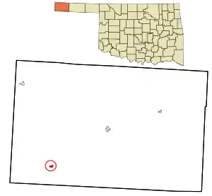 Location in Cimarron County and state of Oklahoma | |
| Coordinates: 36°34′3″N 102°47′37″W | |
| Country | United States |
| State | Oklahoma |
| County | Cimarron |
| Area | |
| • Total | 0.53 sq mi (1.36 km2) |
| • Land | 0.53 sq mi (1.36 km2) |
| • Water | 0.0 sq mi (0.0 km2) |
| Elevation | 4,450 ft (1,360 m) |
| Population (2010) | |
| • Total | 93 |
| • Density | 177/sq mi (68.3/km2) |
| Time zone | UTC-6 (Central (CST)) |
| • Summer (DST) | UTC-5 (CDT) |
| ZIP code | 73937 |
| FIPS code | 40-25850 |
Felt was the original destination of the Elkhart and Santa Fe Railway.[2] This line, both leased to and a wholly owned subsidiary of the Atchison, Topeka and Santa Fe Railway,[3] was built in 1925 from Elkhart, Kansas through Boise City to the town, and extended to Clayton, New Mexico in 1932; but, the whole segment from Boise City to Clayton was abandoned in 1942.[4][5]
Geography
Felt is located in southwestern Cimarron County, near the western end of the Oklahoma Panhandle. Felt is less than five miles north of the Texas border,[6] and just over 12 miles east of the New Mexico border.[7] U.S. Routes 56, 64, and 412 pass concurrently through the community, leading northeast 20 miles (32 km) to Boise City, the Cimarron County seat, and southwest 24 miles (39 km) to the larger Clayton, New Mexico. The town is essentially surrounded by the Rita Blanca National Grassland,[8] and the federally-maintained Felt Picnic Site is just south of town.[9][10]
References
- "Geographic Identifiers: 2010 Demographic Profile Data (G001): Felt CDP, Oklahoma". U.S. Census Bureau, American Factfinder. Archived from the original on February 20, 2015. Retrieved February 20, 2015.
- "Texas County". Dianna Everett, Oklahoma Historical Society. Retrieved September 9, 2020.
- Railroads of Oklahoma, June 6, 1870 to April 1, 1978. State of Oklahoma Department of Transportation, Survey Division. April 1, 1978. p. 37.
- "Cimarron County". Norma Gene Young, Oklahoma Historical Society. Retrieved September 9, 2020.
- "Boise City, OK to Clayton, NM". AbandonedRails.com. Retrieved January 3, 2021.
- "N0130 Rd to Felt, Oklahoma". Google Maps. Retrieved September 11, 2020.
- "Feeder Rd, Clayton, NM to Felt, Oklahoma". Google Maps. Retrieved September 11, 2020.
- "Felt, Oklahoma". Google Maps. Retrieved July 12, 2020.
- "Felt Picnic Site". USDA Forest Service. Retrieved December 31, 2020.
- "Felt Picnic Site to Felt, Oklahoma". Google Maps. Retrieved December 31, 2020.
Municipalities and communities of Cimarron County, Oklahoma, United States | ||
|---|---|---|
| City | 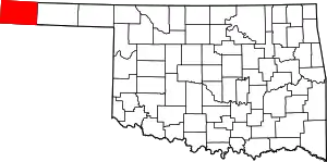 Map of Oklahoma highlighting Cimarron County | |
| Town | ||
| CDPs | ||
| Other unincorporated communities | ||
| ||
| Authority control |
|---|