Figari
Figari is a commune in the Corse-du-Sud department of France on the island of Corsica.
Figari | |
|---|---|
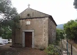
 The chapel of San Ghjambattista di Prunu, in Figari | |
Location of Figari 
| |
 Figari  Figari | |
| Coordinates: 41°29′20″N 9°07′48″E | |
| Country | France |
| Region | Corsica |
| Department | Corse-du-Sud |
| Arrondissement | Sartène |
| Canton | Grand Sud |
| Government | |
| • Mayor (2008–2014) | Roger Simoni |
| Area 1 | 100.22 km2 (38.70 sq mi) |
| Population (2017-01-01)[1] | 1,446 |
| • Density | 14/km2 (37/sq mi) |
| Time zone | UTC+01:00 (CET) |
| • Summer (DST) | UTC+02:00 (CEST) |
| INSEE/Postal code | 2A114 /20114 |
| Elevation | 0–1,366 m (0–4,482 ft) (avg. 125 m or 410 ft) |
| 1 French Land Register data, which excludes lakes, ponds, glaciers > 1 km2 (0.386 sq mi or 247 acres) and river estuaries. | |
Geography
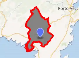
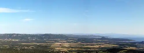
The village of Figari is 43 kilometers (27 mi) to the southeast of Sartène, 20 km (12 mi) to the southwest of Porto-Vecchio and 19 km (12 mi) to the north of Bonifacio. The commune comes from an ancient parish. It includes the center of a large plain where the airport was built in 1975. To the north looms Mount Cagna, which exceeds 1,100 meters (3,600 ft).
To the southeast hills climb to 320 m (1,050 ft) over the village and enclose a reservoir created by damming the Ruisseau de Ventilegne for purposes of water supply and irrigation; additional water can be taken from the Orgone, a small brook which descends from the mountain of Cagna et forms the upper stream of the Stabbiacciu in Porto-Vecchio. To the southwest the commune occupies the east bank of the Bay of Figari, and Ventilegne Point, but not the resort.[2]
Climate
| Climate data for Figari (1981–2010 averages, extremes 1979–present) | |||||||||||||
|---|---|---|---|---|---|---|---|---|---|---|---|---|---|
| Month | Jan | Feb | Mar | Apr | May | Jun | Jul | Aug | Sep | Oct | Nov | Dec | Year |
| Record high °C (°F) | 21.2 (70.2) |
23.5 (74.3) |
30.3 (86.5) |
27.7 (81.9) |
36.0 (96.8) |
37.4 (99.3) |
43.0 (109.4) |
42.7 (108.9) |
36.0 (96.8) |
31.6 (88.9) |
26.0 (78.8) |
22.3 (72.1) |
43.0 (109.4) |
| Average high °C (°F) | 13.5 (56.3) |
13.7 (56.7) |
15.8 (60.4) |
18.2 (64.8) |
22.8 (73.0) |
27.2 (81.0) |
30.7 (87.3) |
30.7 (87.3) |
26.7 (80.1) |
22.5 (72.5) |
17.5 (63.5) |
14.4 (57.9) |
21.2 (70.2) |
| Daily mean °C (°F) | 9.0 (48.2) |
9.0 (48.2) |
10.9 (51.6) |
13.2 (55.8) |
17.3 (63.1) |
21.2 (70.2) |
24.2 (75.6) |
24.3 (75.7) |
21.0 (69.8) |
17.6 (63.7) |
13.1 (55.6) |
10.1 (50.2) |
15.9 (60.6) |
| Average low °C (°F) | 4.5 (40.1) |
4.2 (39.6) |
6.0 (42.8) |
8.1 (46.6) |
11.7 (53.1) |
15.2 (59.4) |
17.7 (63.9) |
17.9 (64.2) |
15.3 (59.5) |
12.8 (55.0) |
8.7 (47.7) |
5.9 (42.6) |
10.7 (51.3) |
| Record low °C (°F) | −7.4 (18.7) |
−8.0 (17.6) |
−5.1 (22.8) |
−4.6 (23.7) |
1.3 (34.3) |
4.6 (40.3) |
8.0 (46.4) |
5.8 (42.4) |
4.4 (39.9) |
−0.5 (31.1) |
−4.7 (23.5) |
−7.6 (18.3) |
−8.0 (17.6) |
| Average precipitation mm (inches) | 65.4 (2.57) |
58.3 (2.30) |
54.4 (2.14) |
59.0 (2.32) |
40.9 (1.61) |
21.9 (0.86) |
11.7 (0.46) |
15.7 (0.62) |
50.6 (1.99) |
90.1 (3.55) |
98.3 (3.87) |
89.0 (3.50) |
655.3 (25.80) |
| Average precipitation days (≥ 1.0 mm) | 7.7 | 7.7 | 6.8 | 7.7 | 5.1 | 2.8 | 1.2 | 2.2 | 5.1 | 7.8 | 10.1 | 10.2 | 74.4 |
| Average snowy days | 0.5 | 0.5 | 0.0 | 0.0 | 0.0 | 0.0 | 0.0 | 0.0 | 0.0 | 0.0 | 0.0 | 0.3 | 1.4 |
| Mean monthly sunshine hours | 128.2 | 144.0 | 204.4 | 218.9 | 292.3 | 332.0 | 375.5 | 331.6 | 250.8 | 195.9 | 132.0 | 114.6 | 2,720.2 |
| Source: Meteo France[3] | |||||||||||||
Population
| Year | Pop. | ±% |
|---|---|---|
| 1962 | 690 | — |
| 1968 | 701 | +1.6% |
| 1975 | 834 | +19.0% |
| 1982 | 1,022 | +22.5% |
| 1990 | 914 | −10.6% |
| 1999 | 1,005 | +10.0% |
| 2008 | 1,157 | +15.1% |
Economy
Viticulture has been practiced in Figari since the Roman era.[4] There are 153 hectares (380 acres) of vineyards on which Syrah, Grenache, and Vermentino are grown. The wine produced falls under the Vin de Corse-Figari AOC.
Transportation
The airport, Figari Sud-Corse Airport, is the third largest of Corsica.[5] It opened in 1975 with a runway of 2,500 meters (8,200 ft). In 2004 it carried 254,000 passengers, 117,000 between the airport and Paris, 63,000 to or from Marseille, 34,000 to or from Nice, and 37,000 in charters.
References
- "Populations légales 2017". INSEE. Retrieved 6 January 2020.
- "France, le trésor des régions: Département: Corse-du-Sud" (in French). Retrieved 2008-05-06..
- "Figari (20)" (PDF). Fiche Climatologique: Statistiques 1981–2010 et records (in French). Meteo France. Archived from the original (PDF) on 20 October 2019. Retrieved 20 October 2019.
- http://www.figari.fr/
- "Figari South Corsica". CCI Ajaccio and South Corsica. Archived from the original on 2014-02-03. Retrieved 2008-05-21. (in French and English). Live flight information can be obtained at: "(FSC) Sud Corse Airport, Figari, FR". Retrieved 2008-05-21.

| Wikimedia Commons has media related to Figari. |