Fluvial processes
In geography and geology, fluvial processes are associated with rivers and streams and the deposits and landforms created by them. When the stream or rivers are associated with glaciers, ice sheets, or ice caps, the term glaciofluvial or fluvioglacial is used.[1][2]
Fluvial processes
Fluvial processes include the motion of sediment and erosion or deposition on the river bed.[3][4]
Erosion by moving water can happen in two ways. Firstly, the movement of water across the stream bed exerts a shear stress directly onto the bed. If the cohesive strength of the substrate is lower than the shear exerted, or the bed is composed of loose sediment which can be mobilized by such stresses, then the bed will be lowered purely by clearwater flow. However, if the river carries significant quantities of sediment, this material can act as tools to enhance wear of the bed (abrasion). At the same time the fragments themselves are ground down, becoming smaller and more rounded (attrition).
Sediment in rivers is transported as either bedload (the coarser fragments which move close to the bed) or suspended load (finer fragments carried in the water). There is also a component carried as dissolved material.
For each grain size there is a specific velocity at which the grains start to move, called entrainment velocity. However the grains will continue to be transported even if the velocity falls below the entrainment velocity due to the reduced (or removed) friction between the grains and the river bed. Eventually the velocity will fall low enough for the grains to be deposited. This is shown by the Hjulström curve.
A river is continually picking up and dropping solid particles of rock and soil from its bed throughout its length. Where the river flow is fast, more particles are picked up than dropped. Where the river flow is slow, more particles are dropped than picked up. Areas where more particles are dropped are called alluvial or flood plains, and the dropped particles are called alluvium.
Even small streams make alluvial deposits, but it is in the flood plains and deltas of large rivers that large, geologically-significant alluvial deposits are found.
The amount of matter carried by a large river is enormous. The names of many rivers derive from the color that the transported matter gives the water. For example, the Huang He in China is literally translated "Yellow River", and the Mississippi River in the United States is also called "the Big Muddy". It has been estimated that the Mississippi River annually carries 406 million tons of sediment to the sea,[5] the Yellow River 796 million tons, and the Po River in Italy 67 million tons.[6]
See also
Fluvial processes
- Bradshaw model – A geographical model, which describes how a river's characteristics vary between the upper course and lower course
- Erosion – Processes which remove soil and rock from one place on the Earth's crust, then transport it to another location where it is deposited
- Downcutting – Process of deepening a stream channel by erosion of the bottom material
- Saltation (geology) – Particle transport by fluids
- Corrosion – Gradual destruction of materials by chemical reaction with its environment (solution)
- Suspension (chemistry) – Heterogeneous mixture of solid particles dispersed in a medium
Fluvial channel patterns
- Channel pattern – Characteristic geometry of a channel system
- Braided river – A network of river channels separated by small, and often temporary, islands
- Meandering river – Sinuous bend in a series in the channel of a river
- Anastomosis – A connection or opening between two things that are normally diverging or branching
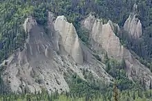
Fluvial landforms
- Channel (geography) – A type of landform in which part of a body of water is confined to a relatively narrow but long region
- Confluence – Meeting of two or more bodies of flowing water
- Cut bank – Outside bank of a water channel, which is continually undergoing erosion
- Crevasse splay – Sediment deposited on a floodplain by a stream which breaks its levees
- Drainage basin – Area of land where precipitation collects and drains off into a common outlet (watershed)
- Esker – Long, winding ridge of stratified sand and gravel associated with former glaciers
- Floodplain – Land adjacent to a stream or river which is flooded during periods of high discharge
- Fluvial terrace – Elongated terraces that flank the sides of floodplains and river valleys
- Canyon – Deep ravine between cliffs (Gorge)
- Gully – Landform created by running water eroding sharply into soil
- Island – Any piece of sub-continental land that is surrounded by water
- Levee § Natural levees
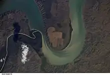
- Meander – Sinuous bend in a series in the channel of a river
- Oxbow lake – U-shaped lake formed by a cut-off meander of a river
- Pendant bar
- Plunge pool – Depression at the base of a waterfall created by the erosional force of falling water and rocks where it lands
- Point bar – A depositional feature of alluvium that accumulates on the inside bend of streams and rivers below the slip-off slope
- Riffle – Shallow landform in a flowing channel
- River – Natural flowing watercourse
- River delta – Silt deposition landform at the mouth of a river
- River island – Exposed land within a river.
- River valley, also known as vale
- Shoal, also known as bar – Natural submerged sandbank that rises from a body of water to near the surface
- Spring (hydrology) – Point at which water emerges from an aquifer to the surface
- Stream – Body of surface water flowing down a channel
- Stream pool – A stretch of a river or stream in which the water is relatively deep and slow moving
- Waterfall – Place where water flows over a vertical drop in the course of a river
- Yazoo stream – Hydrologic term
Related terms
- lacustrine – of or relating to a lake
- maritime – of or relating to a sea
- oceanic – of or relating to an ocean
- palustrine – of or relating to a marsh
References
- K.K.E. Neuendorf, J.P. Mehl, Jr., and J.A. Jackson, eds., 2005, Glossary of Geology. American Geological Institute, Alexandria, Virginia. 800 pp.
- Wilson, W.E. & Moore, J.E. 2003. Glossary of Hydrology, American Geological Institute, Springer, 248pp.
- Charlton, Ro (2008). Fundamentals of fluvial geomorphology. London: Rutledge. p. 234. ISBN 978-0-415-33454-9.
- Wohl, Ellen (2014). Rivers in the Landscape: Science and Management. Wiley-Blackwell. p. 330. ISBN 978-1118414897.
- Mathur, Anuradha; Dilip da Cunha (2001). Mississippi Floods: Designing a Shifting Landscape. New Haven, CT: Yale University Press. ISBN 0-300-08430-7
- Dill, William A. (1990). Inland fisheries of Europe. Rome, Italy: UN Food and Agriculture Organization. ISBN 92-5-102999-7. http://www.fao.org/docrep/009/t0377e/t0377e00.htm
