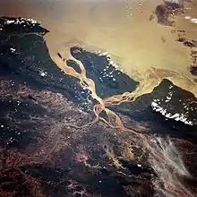
River bifurcation
River bifurcation (from Latin: furca, fork) occurs when a river flowing in a single stream separates into two or more separate streams (called distributaries) which continue downstream. Some rivers form complex networks of distributaries, especially in their deltas. If the streams eventually merge again or empty into the same body of water, then the bifurcation forms a river island.

River bifurcation may be temporary or semi-permanent, depending on the strength of the material which separates the distributaries. For example, a mid-stream island of soil or silt in a delta is most likely temporary. A location where a river divides around a rock fin, e.g. a volcanically formed dike, or a mountain, may be more lasting. A bifurcation may also be man-made, for example when two streams are separated by a long bridge pier.
Examples
- The Casiquiare canal splits off from the Orinoco (an east-flowing river in northern Venezuela that empties into the Caribbean Sea) and heads south to join the Rio Negro, an enormous south-flowing river that eventually joins the Amazon River. The canal therefore provides a navigable channel between the large Orinoco basin and the enormous Amazon basin.
- Canada's aptly-named Divide Creek splits into two branches near Kicking Horse Pass on the Alberta–British Columbia border at the North American continental divide. One branch flows west to the Pacific Ocean; the other flows east and eventually reaches the Atlantic Ocean via Hudson Bay.
- Similarly, at Two Ocean Pass in Wyoming, United States, further south along that very same continental divide, North Two Ocean Creek splits at the Parting of the Waters. One creek is called the Atlantic Creek, which flows east to the Gulf of Mexico via the Yellowstone, Missouri and Mississippi Rivers; the other is called Pacific Creek, which flows west to the Pacific Ocean via the Snake and Columbia Rivers.
- The Hase River in Melle, Germany divides into Hase river and Else river and has been researched as a natural phenomenon.
- A bifurcation of the Nerodimka River (Albanian Nerodimja) in the city of Republic of Kosova/Ferizaj, Kosovo, [lower-alpha 1] (at 42.225556°N 21.256111°E) was a hydrological curiosity as separate streams flowed into the Aegean and the Black Sea.[1] The Nerodimka bifurcation was the first hydrological protected object in the former Yugoslavia (1979). The Nerodimka bifurcation is a strict wildlife sanctuary, category I according to IUCN, with an area of 13.0 ha (about 32 acres). This bifurcation is considered to be an artificial phenomenon, but created under extremely favorable natural conditions.
- In the past, the small Kalaus River in south-western Russia, when reaching the thalweg of the Kuma-Manych Depression at 45°43′N 44°06′E, would split, the two distributaries becoming the headwaters of the West and East Manych Rivers. The former flows west into the Don River and eventually into the Sea of Azov, while the latter flows east, and is lost in the steppe before ever reaching the Caspian Sea. However a dam was built, preventing water from flowing from the Kalaus into the East Manych; thus the Kalaus is now the source of the West Manych only.[2]
- The Bahr Yussef is a channel which splits off the west side of the Nile and drains into the Birket Qarun, an inland sea in the Fayum Depression. Originally a natural bifurcation for flood waters, its flow was increased by canalisation in the 12th Dynasty (about 1900 BC). Around 230BC, the channel of the Nile from which it came (itself a bifurcation) dried up, but has since been fed by a new canal to allow water again to make it from the Nile to Al Fayyum. The entire waterway is over 300 km long, consisting of modern canals taking Nile water from Asyut to Dairut,[3] the old Nile channel then runs alongside the Nile for over 150 km to Lahun, then the Ancient Egyptian canal carries the water into the Fayum Depression.
- In Suriname, the Wayombo and Arrawarra split, the first flowing into the Coppename, the second into the Nickerie.
- The Swedish side of Torne River has a distributary called the Tärendö River, which on average transports 57% of the water of the Torne River into the Kalix River.[4]
- The Barak River splits into two major rivers at the India-Bangladesh border.[5]
- The Karnali River bifurcates in Nepal and the two parts rejoin after flowing into India for 80 kilometers.
Notes and references
Notes:
- Kosovo is the subject of a territorial dispute between the Republic of Kosovo and the Republic of Serbia. The Republic of Kosovo unilaterally declared independence on 17 February 2008. Serbia continues to claim it as part of its own sovereign territory. The two governments began to normalise relations in 2013, as part of the 2013 Brussels Agreement. Kosovo is currently recognized as an independent state by 98 out of the 193 United Nations member states. In total, 113 UN member states recognized Kosovo at some point, of which 15 later withdrew their recognition.
References:
- Tomović, Gordana (2006). "Kosovo on old maps from the XV to the XVIII century". Belgrade: Serbian Academy of Sciences and Arts.
- Alexander Anatolievich Bazelyuk (Базелюк Александр Анатольевич), "АНТРОПОГЕННОЕ ИЗМЕНЕНИЕ ГИДРОГРАФИЧЕСКОЙ СЕТИ КУМО-МАНЫЧСКОЙ ВПАДИНЫ Archived 2009-03-05 at the Wayback Machine" (Anthropogenic changes in the Hydrographic Network of the Kuma-Manych Depression), summary of the Cand. Sci. dissertation. Rostov-on-Don, 2007. (in Russian) Includes maps.
- http://maps.google.co.uk/maps?f=q&source=s_q&hl=en&geocode=&q=dairut&aq=&sll=27.556982,30.836563&sspn=0.14549,0.264187&ie=UTF8&hq=&hnear=Dairut,+Assiut,+Egypt&ll=27.561966,30.809011&spn=0.036219,0.066047&t=h&z=15
- http://www.pajala.se/mun/pajala/www.nsf/English/764B6DC8BFD894E2C1256FB30024F22D?
- "River and Drainage System". Banglapedia. 5 May 2014.