Braided river
A braided river, or braided channel, consists of a network of river channels separated by small, often temporary, islands called braid bars or, in English usage, aits or eyots. Braided streams tend to occur in rivers with high sediment loads and/or coarse grain sizes,[1][2] and in rivers with steeper slopes than typical rivers with straight or meandering channel patterns.[3] They are also associated with rivers with rapid and frequent variation in the amount of water they carry, i.e., with "flashy" rivers, and with rivers with weak banks.[4] Braided channels are found in a variety of environments all over the world, including gravelly mountain streams, sand bed rivers, on alluvial fans, on river deltas, and across depositional plains.[4][5]
Formation
Braided rivers, as distinct from meandering rivers, occur when a threshold level of sediment load or slope is reached while a steep gradient is also maintained. On timescales long enough for the river to evolve, a sustained increase in sediment load will increase the bed slope of the river, so these two conditions may be considered synonymous; and, consequently, a variation of slope is equivalent to a variation in sediment load, provided the amount of water carried by the river is unchanged. A threshold slope was experimentally determined to be 0.016 (ft/ft) for a 0.15 cu ft/s (0.0042 m3/s) stream with poorly sorted coarse sand.[3] Any slope over this threshold created a braided stream, while any slope under the threshold created a meandering stream or – for very low slopes – a straight channel. So the main controlling factor on river development is the amount of sediment that the river carries; once a given system crosses a threshold value for sediment load, it will convert from a meandering system to a braided system. Also important to channel development is the proportion of suspended load sediment to bed load. An increase in suspended sediment allowed for the deposition of fine erosion-resistant material on the inside of a curve, which accentuated the curve and in some instances, caused a river to shift from a braided to a meandering profile.[3] The channels and braid bars are usually highly mobile, with the river layout often changing significantly during flood events.[6]
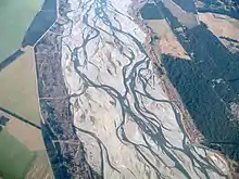
The braided channels may flow within an area defined by relatively stable banks or may occupy an entire valley floor. The Rakaia River in Canterbury, New Zealand has cut a channel 100 metres wide into the surrounding plains; this river transports sediment to a lagoon located on the river-coast interface.
Conditions associated with braided channel formation include:
- an abundant supply of sediment[7]
- high stream gradient[8]
- rapid and frequent variations in water discharge[8]
- erodible banks
- a steep channel gradient
However, in terms of the processes that shape the river, the critical factor that determines whether a stream will meander or braid is bank erodibility. A stream with cohesive banks that are resistant to erosion will form narrow, deep, meandering channels, whereas a stream with highly erodible banks will form wide, shallow channels, preventing the helical flow of the water necessary for meandering and resulting in the formation of braided channels.[9]
Examples
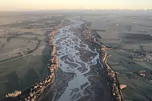
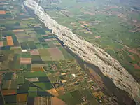
Extensive braided river systems are found in Alaska, Canada, New Zealand's South Island, and the Himalayas, which all contain young, rapidly eroding mountains.
- The enormous Brahmaputra-Jamuna River in Asia is a classic example of a braided river.[10]
- Braided river systems are present in Africa, for example in the Touat Valley.
- A notable example of a large braided stream in the contiguous United States is the Platte River in central and western Nebraska. The sediment of the arid Great Plains is augmented by the presence of the nearby Sandhills region north of the river.
- A portion of the lower Yellow River takes a braided form.[11]
- The Sewanee Conglomerate, a Pennsylvanian coarse sandstone and conglomerate unit[12] present on the Cumberland Plateau near the University of the South, may have been deposited by an ancient braided and meandering river that once existed in the eastern United States.[13] Others have interpreted the depositional environment for this unit as a tidal delta.[14]
Notable braided rivers in Europe:
- Italy
- Tagliamento
- Piave (river)
- Brenta (river)
- Cellina
- Meduna
- Fella
- Magra
- Poland and Belarus
- Sweden
- Sarek National Park
- Sarvesjahka
- Rapaalven
- Sarek National Park
 Rakaia River, South Island, New Zealand
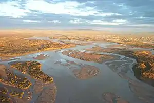 Tanana River, Fairbanks, Alaska, United States
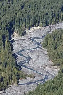
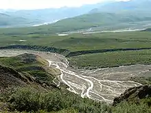 Toklat River, Denali National Park and Preserve, Alaska, United States
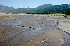 Medano Creek, Great Sand Dunes National Park and Preserve, Colorado, United States
Anastomosing rivers
Anastomosing rivers or streams are similar to braided rivers in that they consist of multiple interweaving channels. However, anastomosing rivers typically consist of a network of low-gradient, narrow, deep channels with stable banks,[9] in contrast to braided rivers, which form on steeper gradients and display less bank stability.
See also
- Ait – Islands found on the River Thames and its tributaries in England
- Anabranch – A section of a river or stream that diverts from the main channel and rejoins it downstream.
- Lagoon – A shallow body of water separated from a larger body of water by barrier islands or reefs
- Shoal – Natural submerged sandbank that rises from a body of water to near the surface
References
- "Braided Rivers". seddepseq.co.uk.
- "Braided Channels". ALevelGeography.com.
- Schumm, S; Kahn, H (1972). "Experimental Study of Channel Patterns". Bulletin of the Geological Society of America. 83 (6): 1755–1770. doi:10.1130/0016-7606(1972)83[1755:esocp]2.0.co;2.
- "Fluvial Landforms: What Is A Braided Channel?". worldatlas.com.
- Braided rivers: perspectives and problems, C. S. Bristow and J. L. Best, Geological Society, London, Special Publications, 75, 1-11, 1 January 1993, https://doi.org/10.1144/GSL.SP.1993.075.01.01
- Hickin, E; Sichingabula, H (1988). "The geomorphic impact of the catastrophic October 1984 flood on the planform of the Squamish River, southwestern British Columbia". Canadian Journal of Earth Sciences. 25 (7): 1078–1087. doi:10.1139/e88-105.
- Gray, D.; Harding, J.S. (2007). "Braided river ecology: A literature review of physical habitats and aquatic invertebrate communities". Science for Conservation (279).
- Leopold, L.B.; Wolman, M.G. (1957). "River channel patterns: Braiding, meandering, and straight". U.S. Geological Survey Professional Papers. 262b: 39–85.
- Easterbrook, Don J. (1999). Surface Processes and Landforms. Prentice Hall.
- Catling, David (1992). Rice in deep water. International Rice Research Institute. p. 177. ISBN 978-971-22-0005-2. Retrieved 23 April 2011.
- Chien, N. (1961). "The braided stream of the lower Yellow River". Scientia Sinica. 10: 734–754.
- Fraley, Thear Kirk (13–16 March 2010). Depositional Environment of Lower Pennsylvanian Sewanee Conglomerate, Lookout Mountain, Georgia. Geological Society of America Northeastern Section (45th Annual) and Southeastern Section (59th Annual) Joint Meeting.
- Churnet, Habte Giorgis; Bergenback, Richard E. (1986). Depositional Systems of Pennsylvanian Rocks in the Cumberland Plateau of Southern Tennessee. Georgia Geological Society.
- Ferm, J.C.; Miliei, R.C.; Eason, J.E. (1972). "Carboniferous depositional environments in the Cumberland Plateau of Southern Tennessee and Northern Alabama". Tennessee Div. Geology Rept. Inv. (33).
Further reading
- Hibbert, Barry; Brown, Kerry, eds. (2001). Braided River Field Guide. Christchurch, N.Z.: Department of Conservation. ISBN 9780478221213.
External links
 Media related to Braided rivers at Wikimedia Commons