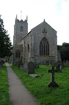
Foulsham
Foulsham is a village and civil parish in the English county of Norfolk.[3] The village is 19.6 miles (31.5 km) west-south-west of Cromer, 17.7 miles (28.5 km) north-west of Norwich and 119 miles (192 km) north-east of London. The village lies 9.4 miles (15.1 km) north-north-east of the town of East Dereham. The nearest railway station is at Sheringham for the Bittern Line which runs between Sheringham, Cromer and Norwich. The nearest airport is Norwich International Airport.
| Foulsham | |
|---|---|
 Holy Innocents' Church | |
 Foulsham Location within Norfolk | |
| Area | 12.56 km2 (4.85 sq mi) |
| Population | 860 (2001 census[1]) 1,021 (Including Bexfield 2011)[2] |
| • Density | 68/km2 (180/sq mi) |
| OS grid reference | TG0325 |
| • London | 119 miles (192 km) |
| Civil parish |
|
| District | |
| Shire county | |
| Region | |
| Country | England |
| Sovereign state | United Kingdom |
| Post town | DEREHAM |
| Postcode district | NR20 |
| Dialling code | 01263 & 01362 |
| Police | Norfolk |
| Fire | Norfolk |
| Ambulance | East of England |
History
The village's name derives from 'sham,' or home, and 'foul,' from the bird. Foulsham has an entry in the Domesday Book of 1085.[4] In the great book Foulsham is recorded by the name Folsam and Folsham it is said to be in the ownership of the King before and after 1066 and Walter Gifford from the king and in the custody of Godric The survey also notes two churches, a mill, twelve cattle, four hundred pigs, fifty goats and 13 sesters[5] of honey. The spelling Folesham was also used.[6]
Puritan emigration
The village gave its name to a family of Puritan dissidents who fled England for the town of Hingham, Massachusetts, (and later Exeter, New Hampshire) and whose spelling of the name was slightly changed to Folsom.[7] Today these American descendants of Foulsham have given rise to Folsom, California, Folsom Street in San Francisco, Folsom Prison—all named for California pioneer and New Hampshire native Joseph Libbey Folsom—as well as General Nathaniel Folsom, who represented New Hampshire in the Continental Congress.[8]
In World War 2 RAF Foulsham played host to No. 100 Group RAF, a special operations unit who flew bombers including the Handley Page Halifax and De Havilland Mosquito in electronic warfare missions. All that remain now are a couple of dilapidated hangars and a few small outbuildings.
The village is largely unspoilt, with a number of attractive 16th and 17th century buildings.
Before Dr. Beeching closed many railway lines in the early 1960s, The village had its own railway station on the line between Dereham and Wroxham.
References
- Census population and household counts for unparished urban areas and all parishes. Office for National Statistics & Norfolk County Council (2001). Retrieved 20 June 2009.
- "Civil Parish population 2011". Neighbourhood Statistics. Office for National Statistics. Retrieved 29 July 2016.
- OS Explorer Map 24 - Norfolk Coast Central. ISBN 0-319-21726-4
- The Domesday Book, Englands Heritage, Then and Now, Editor: Thomas Hinde, Norfolk page 189 ISBN 1-85833-440-3
- Sester is a type of measure; 1 sester of Honey = 28.39059 gal
- Dryburgh, Paul; Hartland, Beth, eds. (2007). Calendar of the Fine Rolls of the Reign of Henry III: 9 to 18 Henry III, 1224-1234. Boydell & Brewer Ltd. p. 676. ISBN 978-1-84383-358-1.
- The Folsoms who eventually settled in Exeter, New Hampshire, continued to hold land near Foulsham in Norfolk for many years after settling in the English colony. Deacon John Folsom, who died in Exeter in 1681 deeded to his son Peter before his death (April 10, 1673) "forty or fifty acres of land in Hingham in ye county of Norfolk (England) near Norrald Comon and formerly held by ye name of Ffulsham at ye Boxbushes."
- A Genealogy of the Folsom Family 1615-1882, Jacob Chapman, Republican Press Association, Concord, N.H., 1882
External links
![]() Media related to Foulsham at Wikimedia Commons
Media related to Foulsham at Wikimedia Commons