Fowlers Bay, South Australia
Fowlers Bay, formerly Yalata, is a town and locality in the Australian state of South Australia located about 658 kilometres (409 mi) north-west of the state capital, Adelaide. Situated on the Nullarbor Plain, it was once an active port and a gateway to the western reaches of the continent, but fell into decline in the 1960s. At the 2016 census, the localities of Fowlers Bay and Coorabie shared a population of 51.[2]
| Fowlers Bay South Australia | |||||||||||||||
|---|---|---|---|---|---|---|---|---|---|---|---|---|---|---|---|
 Town of Fowlers Bay | |||||||||||||||
 Fowlers Bay | |||||||||||||||
| Coordinates | 31°59′25″S 132°26′09″E[1] | ||||||||||||||
| Population | 51 (shared with Coorabie) (2016 census)[2][lower-alpha 1] | ||||||||||||||
| Established | 10 July 1890 (town) 8 February 2001 (locality)[3][4] | ||||||||||||||
| Postcode(s) | 5690[5] | ||||||||||||||
| Elevation | 3 m (10 ft)[6] | ||||||||||||||
| Time zone | ACST (UTC+9:30) | ||||||||||||||
| • Summer (DST) | ACST (UTC+10:30) | ||||||||||||||
| Location |
| ||||||||||||||
| LGA(s) | Pastoral Unincorporated Area[1] | ||||||||||||||
| Region | Eyre Western[7] | ||||||||||||||
| County | Hopetoun[1] | ||||||||||||||
| State electorate(s) | Flinders[8] | ||||||||||||||
| Federal Division(s) | Grey[9] | ||||||||||||||
| |||||||||||||||
| |||||||||||||||
| Footnotes | Locations[1][5] Adjoining localities[1] | ||||||||||||||
History
European exploration
The coastline around Fowlers Bay was first mapped in 1627 by François Thijssen, a Dutch sea captain. His ship was the Golden Seahorse (Gulden Zeepard).[10] Fowlers Bay was named on 28 January 1802 by Matthew Flinders after his first lieutenant, Robert Fowler.[11]
Edward John Eyre set up base camp here in 1840 during his epic journeys across the Nullarbor Plain. By this time the area was well known to American and French whaling ships; Eyre documents seeing whalers in the area.[12]
Settlement
In the 1860s, the first pastoral leases were established by William Swan and Robert Barr Smith, forming Yalata station, a farming property whose boundaries extended from the Head of the Bight in the west to Streaky Bay in the east.[10]
The town was surveyed in March 1890 and proclaimed as the Town of Yalata on 10 July 1890.[3] Its name was changed to Fowler's Bay on 19 September 1940 to agree with the bay and to prevent dual naming.[1][13] The town is on Port Eyre at the western end of the larger Fowlers Bay.[14] Yalata now refers to a nearby township.
Boundaries for the locality of Fowlers Bay which include the town were created on 8 February 2001.[4]
Heritage listings
Fowlers Bay contains one place listed on the South Australian Heritage Register - Whale Bone Area and the Point Fowler Structure.[15]
In the 2000s
Today Fowlers Bay is located in the Pastoral Unincorporated Area of South Australia (only 15% of the state is under Local Government). The town does not receive reticulated power or water. It is currently a popular overnight destination between Nundroo and Penong, and its fishing facilities, beaches and surrounding historical ruins gives the town some interest for tourists and sightseers. There are no sealed roads to Fowlers Bay and visitors should seek advice before driving across the saltwater bog behind the town.
Visually the town is dominated by a large sand dune that protects the town from the Southern Ocean. Southern right whales have recolonised into the area in recent years, with the bay providing a small but ideal sanctuary. Bottlenose dolphins and Australian sea lions may also be found.
The ruins of the homestead of the Yalata station can be found several kilometres from the town. There is a small cemetery on the outskirts of the town.
Governance
Fowlers Bay is located within the federal Division of Grey, the state electoral district of Flinders and the Pastoral Unincorporated Area of South Australia.[1][8][9] In the absence of a local government authority, the community in Fowlers Bay receives municipal services from a state government agency, the Outback Communities Authority.[16]
Gallery
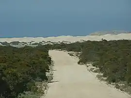 The road to Fowlers Bay
 Jetty, Fowlers Bay
 Cemetery, Fowlers Bay
Climate
Fowlers Bay has a cool semi-arid climate (Köppen BSk), with moderating influences from the Great Australian Bight. Summers are typically warm to very warm and almost rainless, although when hot northerly winds from the interior occur extreme heat may result. Winters are pleasant, although often windy, and damp though not wet. Three-fifths of the meagre annual rainfall of around 300 millimetres or 12 inches typically occurs between May and August, but only three months have ever exceeded 115 millimetres or 4.53 inches: June 1890 with 169.1 millimetres (6.66 in), August 1915 with 122.5 millimetres (4.82 in) and May 1956 with 130.8 millimetres (5.15 in).[17] The wettest year has been 1890 with 505.8 millimetres (19.91 in) and the driest 1959 with 89.1 millimetres (3.51 in).[17] The highest recorded temperature was 48.4 °C (119.1 °F) and the lowest −3.2 °C (26.2 °F).
| Climate data for Fowlers Bay, South Australia | |||||||||||||
|---|---|---|---|---|---|---|---|---|---|---|---|---|---|
| Month | Jan | Feb | Mar | Apr | May | Jun | Jul | Aug | Sep | Oct | Nov | Dec | Year |
| Record high °C (°F) | 48.4 (119.1) |
44.1 (111.4) |
42.8 (109.0) |
40.0 (104.0) |
33.3 (91.9) |
28.3 (82.9) |
27.2 (81.0) |
30.6 (87.1) |
38.9 (102.0) |
43.3 (109.9) |
44.4 (111.9) |
46.0 (114.8) |
48.4 (119.1) |
| Average high °C (°F) | 25.1 (77.2) |
24.1 (75.4) |
24.2 (75.6) |
22.5 (72.5) |
20.3 (68.5) |
17.8 (64.0) |
17.0 (62.6) |
18.2 (64.8) |
20.3 (68.5) |
21.8 (71.2) |
23.2 (73.8) |
24.0 (75.2) |
21.5 (70.7) |
| Average low °C (°F) | 17.1 (62.8) |
17.0 (62.6) |
16.0 (60.8) |
13.4 (56.1) |
10.3 (50.5) |
8.1 (46.6) |
6.9 (44.4) |
7.6 (45.7) |
9.6 (49.3) |
11.8 (53.2) |
13.9 (57.0) |
15.7 (60.3) |
12.3 (54.1) |
| Record low °C (°F) | 7.2 (45.0) |
2.8 (37.0) |
5.0 (41.0) |
3.9 (39.0) |
−1.1 (30.0) |
−3.2 (26.2) |
−1.8 (28.8) |
−0.6 (30.9) |
1.7 (35.1) |
0.0 (32.0) |
3.9 (39.0) |
3.0 (37.4) |
−3.2 (26.2) |
| Average rainfall mm (inches) | 8.4 (0.33) |
12.3 (0.48) |
13.7 (0.54) |
21.6 (0.85) |
42.0 (1.65) |
51.7 (2.04) |
43.5 (1.71) |
36.1 (1.42) |
21.8 (0.86) |
20.9 (0.82) |
16.5 (0.65) |
12.0 (0.47) |
300.5 (11.82) |
| Average rainy days (≥ 0.2 mm) | 2.4 | 2.4 | 3.6 | 5.9 | 9.9 | 11.5 | 11.9 | 10.4 | 7.1 | 6.0 | 4.4 | 3.3 | 78.8 |
| Source: Bureau of Meteorology[6] | |||||||||||||
See also
References
Notes
- For the 2016 census, the 'State Suburb of Fowlers Bay' consisted of the localities of Coorabie and Fowlers Bay.
Citations
- "Search results for 'Fowlers Bay, LOCB' with the following datasets selected - 'Suburbs and localities', 'Counties', 'Hundreds', 'Local Government Areas', 'SA Government Regions' and 'Gazetteer'". Location SA Map Viewer. South Australian Government. Retrieved 27 January 2019.
- Australian Bureau of Statistics (27 June 2017). "Fowlers Bay (State Suburb)". 2016 Census QuickStats. Retrieved 27 January 2019.

- Cockburn, John A. (10 July 1890). "untitled proclamation re the Town of Yalata" (PDF). The South Australian Government Gazette. Government of South Australia. p. 56. Retrieved 27 January 2019.
- Lawson, Robert (8 February 2001). "GEOGRAPHICAL NAMES ACT 1991 Notice to Assign Names and Boundaries to Places" (PDF). The South Australian Government Gazette. Government of South Australia. p. 516. Retrieved 27 January 2019.
...assign the boundaries LYNDHURST, LEIGH CREEK, COPLEY, PARACHILNA, MARLA, NEPABUNNA, OODNADATTA, ANDAMOOKA, PENONG, COORABIE and FOWLERS BAY...
- "Fowlers Bay, South Australia (Postcode)". postcodes-australia.com. Retrieved 24 July 2016.
- "Climate Statistics for Fowlers Bay, South Australia". Retrieved 20 January 2012.
- "Eyre and Western South Australian Government Region" (PDF). Government of South Australia. Retrieved 29 January 2016.
- "District of Flinders Background Profile". Electoral Commission SA. Retrieved 9 September 2015.
- "Federal electoral division of Grey" (PDF). Australian Electoral Commission. Retrieved 24 July 2015.
- Fowlers Bay, South Australia
- Flinders, Matthew (1966) [1814]. A Voyage to Terra Australis : undertaken for the purpose of completing the discovery of that vast country, and prosecuted in the years 1801, 1802, and 1803 in His Majesty's ship the Investigator, and subsequently in the armed vessel Porpoise and Cumberland Schooner; with an account of the shipwreck of the Porpoise, arrival of the Cumberland at Mauritius, and imprisonment of the commander during six years and a half in that island (Facsimile ed.). Adelaide; Facsimile reprint of: London : G. and W. Nicol, 1814 ed. In two volumes, with an Atlas (3 volumes): Libraries Board of South Australia. p. 211. Retrieved 3 January 2014.CS1 maint: location (link)
- Edward John Eyre. "Book 2. - Australian Discovery by Land - XV Eyre's journey from Fowler's Bay to Albany in 1841".
- McEwin, A. Lyell (19 September 1940). "ALTERATION OF NAMES OF TOWNS" (PDF). The South Australian Government Gazette. Government of South Australia. pp. 569–570. Retrieved 24 January 2019.
- "Placename Details: Port Eyre". Property Location Browser. Government of South Australia. 1 March 2010. SA0023421. Retrieved 24 December 2016.
- "Whale Bone Area and the Point Fowler Structure, Fowlers Bay Conservation Reserve (designated places of archaeological significance)". South Australian Heritage Register. Department of Environment, Water and Natural Resources - State Heritage Branch. Retrieved 24 July 2016.
- "Communities (serviced by the Outback Communities Authority)". Outback Communities Authority. Archived from the original on 2 March 2016. Retrieved 24 July 2016.
- Australian Bureau of Meteorology; Monthly rainfall – Fowlers Bay
External links
- Fowlers Bay - Nullarbor Travel Guide Australia
- The Township of Yalata
- Photos of Fowlers Bay cemetery and its headstones
Coastal bays and inlets of South Australia | |||
|---|---|---|---|
| West coast | |||
| Spencer Gulf | |||
| Investigator Strait | |||
| Kangaroo Island south and west coasts | |||
| Gulf St Vincent | |||
| Backstairs Passage | |||
| South east coast | |||
| Mainland |
| ||
| |||