Fulking
Fulking is a village and civil parish in the Mid Sussex District of West Sussex, England. The parish lies wholly with the South Downs National Park.
| Fulking | |
|---|---|
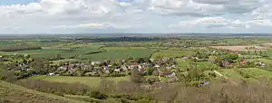 Fulking from the South Downs Way | |
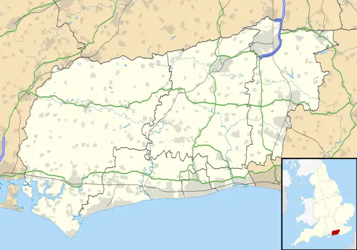 Fulking Location within West Sussex | |
| Area | 6.28 km2 (2.42 sq mi) [1] |
| Population | 250 [1] 2001 Census 303 2011 Census[2] |
| • Density | 40/km2 (100/sq mi) |
| OS grid reference | TQ247114 |
| • London | 42 miles (68 km) N |
| Civil parish |
|
| District | |
| Shire county | |
| Region | |
| Country | England |
| Sovereign state | United Kingdom |
| Post town | HENFIELD |
| Postcode district | BN5 |
| Dialling code | 01273 |
| Police | Sussex |
| Fire | West Sussex |
| Ambulance | South East Coast |
| UK Parliament | |
| Website | Fulking community website |
The parish is located on the north slopes of the South Downs, five miles (8 km) to the north-west of Brighton. The civil parish covers an area of 628.31 hectares (1,552.6 acres).
History
Fulking was originally part of the parish of Edburton. The parish was unusual in that part lay in Bramber rape and Burbeach hundred and part in Lewes rape and Poynings hundred (usually parish boundaries followed rape boundaries). The civil parish of Fulking was created from the eastern half of the ancient parish (sometimes referred to as 'the ecclesiastical parish') in 1894, after the creation of the administrative counties of West Sussex (which incorporated Bramber Rape) and East Sussex (which incorporated Lewes Rape) in 1889. The remainder of Edburton was added to Upper Beeding parish in 1933.[3] Fulking transferred from East Sussex to West Sussex with the creation of Mid Sussex District in 1974.[4]
Governance
Civil Parish
Fulking Parish Council has five parish councillors.[5] The Parish Council holds an annual meeting (usually in May) and at least three other ordinary meetings a year; additional meetings may be called to discuss planning applications.[6] Meetings are held at Fulking Village Hall.[7]
Non-metropolitan district
Fulking civil parish is in Hurstpierpoint and Downs Ward of the non-metropolitan district of Mid Sussex;[8] the ward returns three councillors to Mid Sussex District Council.[9]
The responsibilities of district councils usually include local planning, housing, local highways, building, environmental health, and refuse collection.[10] However, the parish lies wholly with the South Downs National Park. The planning authority for Fulking is therefore the South Downs National Park Authority (SDNPA), the statutory planning authority for the National Park area.[11]
Non-metropolitan county
Fulking civil parish is in the Hurstpierpoint and Bolney electoral division of the non-metropolitan county of West Sussex.[8] The division returns one councillor to West Sussex County Council.[12]
The functions of county councils include education, transport, strategic planning, fire services, consumer protection, refuse disposal, social services and libraries.[10]
Westminster Constituency
Fulking civil parish is in the Arundel and South Downs constituency.[8]
Landmarks
Listed buildings
Fulking civil parish contains 22 listed buildings. Of these, one is Grade II* and the remaining 21 are Grade II.
The Grade II* listed building is:
- Perching Manor Farmhouse (List Entry Number 1354845), an L-shaped 18th century house.[13]
Scheduled monuments
The parish contains four scheduled monuments.
- Motte-and-bailey castle on Edburton Hill (List Entry Number 1012171), the earthworks and interior area of a castle believed to date from the immediate post-Conquest period, soon after October 1066.[14][15]
- Bowl barrow on Scabes Castle (List Entry Number 1014950), lying on the parish boundary between Fulking and Poynings, an originally circular funerary monument, now a roughly oval mound, having been levelled by modern ploughing on its eastern side.[16]
- Bowl barrow on Fulking Hill (List Entry Number 1014951), a circular mound which shows signs of part-excavation in the past.[17]
- Deserted medieval settlement and associated cultivation terraces on Perching Hill (List Entry Number 1015125). Downland was rarely inhabited during the medieval period; the establishment of the settlement is probably due to the presence of an underground water course in the coombe, indicated by a well about 60 m to the west of the monument.[18]
1886 Water supply system
A distinctive feature of Fulking is the remains of a late Nineteenth Century water supply system. A hydraulic ram, housed in small building near the Shepherd and Dog public house, pumped water from a stream up hill to a reservoir at the western end of the village street, where a drinking fountain and water trough were provided. The water was then fed by gravity to two further reservoirs, supplying two hand pumps along the street.[19]
The building housing the hydraulic ram bears the inscription, on ceramic tiles, ‘He sendeth springs into the valleys which run among the hills | Oh that men would praise the Lord for his goodness’ (Psalm 104, verse 10 and Psalm 107, verse 8). It is a Grade II listed building (List Entry Number 1354830).[20] The drinking fountain bears the inscription, on ceramic tiles, ‘To the glory of God | And in honour of John Ruskin | Psalm LXXVIII | That they might set their hope in God, and not forget the works of God | But keep his commandments | Who brought streams also out of the rock’ (Psalm 58, verses 7 and 16). The drinking fountain is also listed (List Entry Number 1334374),[21] as are the two associated hand pumps in the village (List Entry Number 1096867 and List Entry Number 1285792).[22][23]
The system was installed in 1886. Henry Willett, a wealthy brewer from Brighton, and John Ruskin are usually credited with devising and instigating the water supply scheme.[19] However, contemporary newspaper accounts give credit for the scheme to Rev. F. Gell, rector to Edburton, with generous support from Henry Willet.[24][25] Ruskin himself, in a letter to Willet dated Brantwood, 16 June 1887, said ‘I was grieved by your inscription on the fountain, for it made my name far too conspicuous, nor did I feel that the slightest honour was owing to me in the matter’.[26]
Parish Church
As a consequence of its history, Fulking has no parish church of its own. Ecclesiastically, it remains part of the parish of Edburton, and uses St Andrew’s church, Edburton, as its parish church.[27][28] The church is part of the Downland Benefice, together with the churches in Poynings, Newtimber and Pyecombe.[29]
Sport
Fulking is the home of the Preston Nomads Cricket Club. The club was founded in 1927 Preston, Brighton. When it was founded, the club did not have its own ground; hence the ‘Nomads’ element of the name. It played on whatever council-run pitches were available. in 1937, Spenta (Spen) Cama, one of the founding members of the club, bought some fields in Fulking which formed the nucleus of the club’s current ground. Further land purchases in 1955 and 1991 extended the club’s grounds to their current size. The club’s pavilion was opened in 1982.[30] Preston Nomads Cricket Club was a founder member of the Sussex Cricket League in 1971.[31]
The club runs four men's Saturday League teams and one on Sundays.[31] The club has a junior section and runs a coaching programme.[32]
In culture
In The Meaning of Liff by Douglas Adams and John Lloyd "Fulking" is given the definition "pretending not to be in when the carol singers come round."[33]
References
- "2001 Census: West Sussex – Population by Parish" (PDF). West Sussex County Council. Archived from the original (PDF) on 8 June 2011. Retrieved 7 April 2009.
- "Civil Parish population 2011". Neighbourhood Statistics. Office for National Statistics. Retrieved 29 September 2016.
- Baggs, A P; Currie, C R J; Elrington, C R; Keeling, S M; Rowland, A M. "'Edburton', in A History of the County of Sussex: Volume 6 Part 3, Bramber Rape (North-Eastern Part) Including Crawley New Town, ed. T P Hudson (London, 1987), pp. 45-48". British History Online. Institute of Historical Research. Retrieved 3 February 2020.
- Allen, John. "Fulking – Good Shepherd". Sussex Parish Churches. Retrieved 3 February 2020.
- "Parish Council Members". Fulking community website. Fulking Village. Retrieved 15 February 2020.
- "Standing Orders" (PDF). (via Fulking community website). Fulking Parish Council. Retrieved 15 February 2020.
- "Fulking Parish Council – Meetings". Fulking community website. Fulking Village. Retrieved 15 February 2020.
- "Election Maps". Ordnance Survey. Ordnance Survey. Retrieved 13 February 2020.
- "Your Councillors by Ward". Mid Sussex District Council. Mid Sussex District Council. Retrieved 13 February 2020.
- "England : Detailed information on the administrative structure within England". Office for National Statistics. Office for National Statistics. Retrieved 13 February 2020.
- "Planning". South Downs National Park. South Downs National Park Authority. Retrieved 1 February 2020.
- "Electoral division boundaries". West Sussex County Council. West Sussex County Council. Retrieved 15 February 2020.
- Historic England. "Perching Manor Farmhouse (1354845)". National Heritage List for England.
- Film of the site, 'Sussex Walks: Exploring Edburton Castle in West Sussex', published on Youtube 27 November 2017, Richard Vobes. https://www.youtube.com/watch?v=qzMd9w3OMzM
- Historic England. "Motte and bailey castle on Edburton Hill (1012171)". National Heritage List for England.
- Historic England. "Bowl barrow on Scabes Castle (1014950)". National Heritage List for England.
- Historic England. "Bowl barrow on Fulking Hill (1014951)". National Heritage List for England.
- Historic England. "Deserted medieval settlement and associated cultivation terraces on Perching Hill (1015125)". National Heritage List for England.
- Fulking : Conservation Area Character Appraisal and Management Plan (PDF). Midhurst: South Downs National Park Authority. December 2019. Retrieved 23 February 2020.
- Historic England. "The Stream Basin and Conduit-House (Grade II) (1354830)". National Heritage List for England. Retrieved 23 February 2020.
- Historic England. "Reservoir, Drinking Fountain and Water Trough (Grade II) (1334374)". National Heritage List for England. Retrieved 23 February 2020.
- Historic England. "Water Pump (Grade II) (1096867)". National Heritage List for England. Retrieved 23 February 2020.
- Historic England. "The Village Pump (Grade II) (1285792)". National Heritage List for England. Retrieved 23 February 2020.
- "Saunterings in Sussex". Brighton Gazette. 10 September 1885. p. 8.
- "Edburton : Welcome Improvements". Mid Sussex Times. 16 March 1886. p. 5.
- Cook, E. T.; Wedderburn, Alexander (eds.). The works of John Ruskin : Volume 37. London: George Allen. p. 591. Retrieved 23 February 2020.
- "St. Andrew's Church". Fulking Community Website. Fulking Village. Retrieved 3 February 2020.
- "'Parishes: Fulking', in A History of the County of Sussex: Volume 7, the Rape of Lewes, ed. L F Salzman (London, 1940), pp. 202-204". British History Online. Institute of Historical Research. Retrieved 3 February 2020.
- "Our Churches". The Downland Benefice. The Downland Benefice. Retrieved 3 February 2020.
- "Spen Cama". Preston Nomads C.C. Take Note Publishing Ltd. Retrieved 16 February 2020.
- "History". Preston Nomads C.C. Take Note Publishing Ltd. Retrieved 16 February 2020.
- "PNCC Junior Cricket". Preston Nomads C.C. Take Note Publishing Ltd. Retrieved 16 February 2020.
- Adams, D and Lloyd, J. The Meaning of Liff. Pan Books/Faber and Faber ISBN 0-330-28121-6, p. 55
Gallery
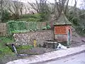 Fulking Spring
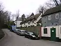 The Shepherd and Dog pub by Fulking
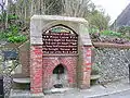 John Ruskin tap
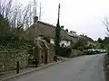 Fulking village
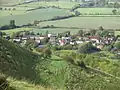 The village from the South Downs
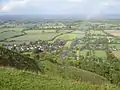 The village in context
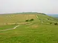 The South Downs Way
.jpg.webp) Preston Nomads Cricket Club is based in Fulking
Preston Nomads Cricket Club is based in Fulking
External links
| Wikimedia Commons has media related to Fulking. |
- Fulking community website (acts as Fulking Parish Council's website)
- The Downland Benefice (includes St Andrew’s Church, Edburton, Fulking's parish church)
- Preston Nomads Cricket Club
