Poynings
Poynings (/ˈpɔɪnɪŋz/ or locally /ˈpʌnɪŋz/)[3] is a village and civil parish in the Mid Sussex District of West Sussex, England. The parish lies wholly with the South Downs National Park. The planning authority for Pyecombe is therefore the South Downs National Park Authority (SDNPA), the statutory planning authority for the National Park area.[4]
| Poynings | |
|---|---|
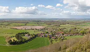 Poynings from the South Downs | |
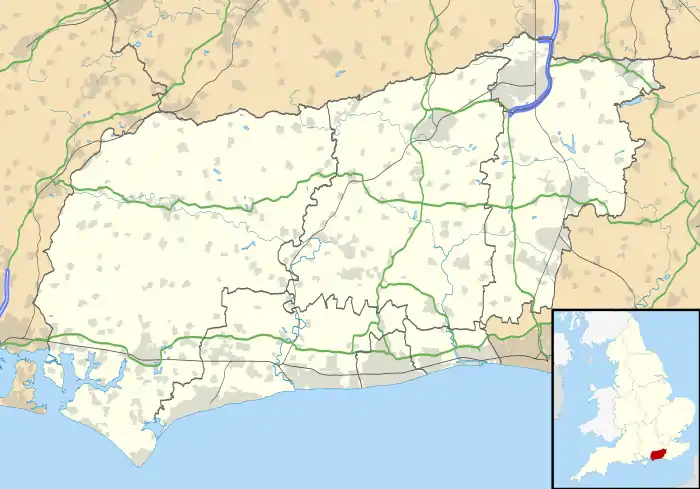 Poynings Location within West Sussex | |
| Area | 6.66 km2 (2.57 sq mi) [1] |
| Population | 287 [1] 2001 Census 432 (2011 Census)[2] |
| • Density | 43/km2 (110/sq mi) |
| OS grid reference | TQ264120 |
| • London | 42 miles (68 km) N |
| Civil parish |
|
| District | |
| Shire county | |
| Region | |
| Country | England |
| Sovereign state | United Kingdom |
| Post town | BRIGHTON |
| Postcode district | BN45 |
| Dialling code | 01273 |
| Police | Sussex |
| Fire | West Sussex |
| Ambulance | South East Coast |
| UK Parliament | |
| Website | Poynings village |
The village is located on the north side of the South Downs near Devil's Dyke, five miles (8 km) north-west of Brighton. The civil parish covers an area of 665.5 hectares (1,644 acres) and has a population of 287 (2001 census), including Newtimber and increasing to 432 at the 2011 Census.[2]
There is a public house, the Royal Oak.
Holy Trinity Church
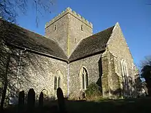
Holy Trinity Church is Poynings’ parish church, located at the east end of the village, on The Street, at 50°53′38.6″N 0°12′11.5″W.
The church is in the Church of England Diocese of Chichester, Archdeaconry of Horsham.
The church is a Grade I listed building, described in the National Heritage List for England as 'One of the finest village medieval churches in Sussex' (List Entry Number 1285135, first listed 28 October 1957).[5]
Listed Buildings and Scheduled Monuments
Poynings civil parish contains ten listed buildings. Of these, one is Grade I and the remaining nine are Grade II. The parish contains four scheduled monuments.
Listed buildings
Grade I listed buildings:
- The Parish Church of the Holy Trinity (List Entry Number 1285135) – see above.[5]
Scheduled monuments
- Bowl barrow on Scabes Castle (List Entry Number 1014950), lying on the parish boundary between Poynings and Fulking, an originally circular funerary monument, now a roughly oval mound, having been levelled by modern ploughing on its eastern side.[6]
- Devil's Dyke hillfort (List Entry Number 1014953), a large univallate hillfort dating to the Iron Age, situated on a chalk spur which forms part of the Sussex Downs.[7]
- Post-medieval stock enclosure at Devil's Dyke (List Entry Number 1014954), which survives as a north east-south west aligned, rectangular earthwork. It was used for the stalling of working oxen and as winter housing for fatstock cattle. Before excavation in 1908, it was assumed to be a burial mound.[8]
- Romano-British farmstead 480m north west of Devil's Dyke Cottages (List Entry Number 1017649), which survives largely in buried form and is visible as an area of hollows and uneven ground.[9]
Cora's Corner
In the village opposite Holy Trinity Church there is a small sheltered memorial called Cora's Corner, which pays tribute to a former resident of Poynings; two benches in the shelter, Judy's Seat and Merrilee's Seat, are tributes to Cora's two daughters. The road linking Cora's Corner to the Royal Oak is called Cora's Walk.
References
- "2001 Census: West Sussex – Population by Parish" (PDF). West Sussex County Council. Archived from the original (PDF) on 8 June 2011. Retrieved 10 April 2009.
- "Civil Parish population 2011". Neighbourhood Statistics. Office for National Statistics. Retrieved 1 October 2016.
- "Parishes: Poynings". British Histories Online. Retrieved 15 October 2015.
- "Planning". South Downs National Park. South Downs National Park Authority. Retrieved 1 February 2020.
- Historic England. "The Parish Church of the Holy Trinity (1285135)". National Heritage List for England.
- Historic England. "Bowl barrow on Scabes Castle (1014950)". National Heritage List for England.
- Historic England. "Devil's Dyke hillfort (1014953)". National Heritage List for England.
- Historic England. "Post-medieval stock enclosure at Devil's Dyke (1014954)". National Heritage List for England.
- Historic England. "Romano-British farmstead 480m north west of Devil's Dyke Cottages (1017649)". National Heritage List for England.
External links
| Wikimedia Commons has media related to Poynings. |
- Poynings village website
- Poynings Parish Council
- The Downland Benefice: Poynings Church
- Roughwood web site: Holy Trinity, Poynings, West Sussex - Photographs of the church, taken on 18 January 2004