Fulton, South Dakota
Fulton is a town in Hanson County, South Dakota, United States. It is part of the Mitchell, South Dakota Micropolitan Statistical Area. The population was 91 at the 2010 census.
Fulton, South Dakota | |
|---|---|
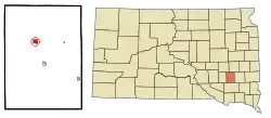 Location in Hanson County and the state of South Dakota | |
| Coordinates: 43°43′38″N 97°49′22″W | |
| Country | United States |
| State | South Dakota |
| County | Hanson |
| Area | |
| • Total | 0.85 sq mi (2.21 km2) |
| • Land | 0.85 sq mi (2.21 km2) |
| • Water | 0.00 sq mi (0.00 km2) |
| Elevation | 1,325 ft (404 m) |
| Population | |
| • Total | 91 |
| • Estimate (2019)[3] | 96 |
| • Density | 112.41/sq mi (43.41/km2) |
| Time zone | UTC-6 (Central (CST)) |
| • Summer (DST) | UTC-5 (CDT) |
| ZIP code | 57340 |
| Area code(s) | 605 |
| FIPS code | 46-23220[4] |
| GNIS feature ID | 1255181[5] |
History
The town was laid out in 1887. Some say that the town was named for Robert Fulton, inventor of the first commercially successful steamboat,[6] while others believe the town has the name of a railroad employee.[7] A post office has been in operation in Fulton since 1887.[8]
Geography
Fulton is located at 43°43′38″N 97°49′22″W (43.727173, -97.822639).[9]
According to the United States Census Bureau, the town has a total area of 0.85 square miles (2.20 km2), all land.[10]
Fulton has been assigned the ZIP code 57340 and the FIPS place code 23220.
Demographics
| Historical population | |||
|---|---|---|---|
| Census | Pop. | %± | |
| 1920 | 214 | — | |
| 1930 | 171 | −20.1% | |
| 1940 | 168 | −1.8% | |
| 1950 | 139 | −17.3% | |
| 1960 | 135 | −2.9% | |
| 1970 | 101 | −25.2% | |
| 1980 | 108 | 6.9% | |
| 1990 | 70 | −35.2% | |
| 2000 | 86 | 22.9% | |
| 2010 | 91 | 5.8% | |
| 2019 (est.) | 96 | [3] | 5.5% |
| U.S. Decennial Census | |||
2010 census
As of the census[2] of 2010, there were 91 people, 38 households, and 26 families residing in the town. The population density was 107.1 inhabitants per square mile (41.4/km2). There were 44 housing units at an average density of 51.8 per square mile (20.0/km2). The racial makeup of the town was 100.0% White.
There were 38 households, of which 28.9% had children under the age of 18 living with them, 60.5% were married couples living together, 2.6% had a female householder with no husband present, 5.3% had a male householder with no wife present, and 31.6% were non-families. 28.9% of all households were made up of individuals, and 5.3% had someone living alone who was 65 years of age or older. The average household size was 2.39 and the average family size was 2.77.
The median age in the town was 42.8 years. 27.5% of residents were under the age of 18; 3.3% were between the ages of 18 and 24; 20.9% were from 25 to 44; 24.2% were from 45 to 64; and 24.2% were 65 years of age or older. The gender makeup of the town was 58.2% male and 41.8% female.
2000 census
As of the census[4] of 2000, there were 86 people, 38 households, and 29 families residing in the town. The population density was 100.7 people per square mile (39.1/km2). There were 41 housing units at an average density of 48.0 per square mile (18.6/km2). The racial makeup of the town was 100.00% White.
There were 38 households, out of which 23.7% had children under the age of 18 living with them, 76.3% were married couples living together, 2.6% had a female householder with no husband present, and 21.1% were non-families. 21.1% of all households were made up of individuals, and 7.9% had someone living alone who was 65 years of age or older. The average household size was 2.26 and the average family size was 2.60.
In the town, the population was spread out, with 17.4% under the age of 18, 3.5% from 18 to 24, 25.6% from 25 to 44, 29.1% from 45 to 64, and 24.4% who were 65 years of age or older. The median age was 48 years. For every 100 females, there were 100.0 males. For every 100 females age 18 and over, there were 82.1 males.
The median income for a household in the town was $26,875, and the median income for a family was $30,000. Males had a median income of $26,875 versus $22,813 for females. The per capita income for the town was $13,062. There were 15.6% of families and 24.7% of the population living below the poverty line, including 77.8% of under eighteens and 10.0% of those over 64.
References
- "2019 U.S. Gazetteer Files". United States Census Bureau. Retrieved July 30, 2020.
- "U.S. Census website". United States Census Bureau. Retrieved 2012-06-21.
- "Population and Housing Unit Estimates". United States Census Bureau. May 24, 2020. Retrieved May 27, 2020.
- "U.S. Census website". United States Census Bureau. Retrieved 2008-01-31.
- "US Board on Geographic Names". United States Geological Survey. 2007-10-25. Retrieved 2008-01-31.
- Chicago and North Western Railway Company (1908). A History of the Origin of the Place Names Connected with the Chicago & North Western and Chicago, St. Paul, Minneapolis & Omaha Railways. p. 176.
- Federal Writers' Project (1940). South Dakota place-names, v.1-3. University of South Dakota. p. 38.
- "Hanson County". Jim Forte Postal History. Retrieved 4 April 2015.
- "US Gazetteer files: 2010, 2000, and 1990". United States Census Bureau. 2011-02-12. Retrieved 2011-04-23.
- "US Gazetteer files 2010". United States Census Bureau. Archived from the original on 2012-07-02. Retrieved 2012-06-21.
Municipalities and communities of Hanson County, South Dakota, United States | ||
|---|---|---|
| Cities |  | |
| Towns | ||
| Unincorporated communities | ||
| ||