Għasri
Għasri (Maltese: L-Għasri) is a village in the western part of Gozo, Malta, with a population of 525 people (as of March 2014).[1] By population, it is the smallest village in Gozo after San Lawrenz, and the third-smallest in the Maltese Islands, after Bidnija and Mdina. Għasri, however, has a relatively large area.
Għasri
L-Għasri | |
|---|---|
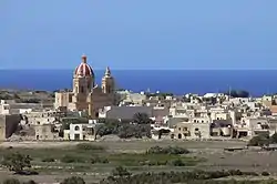 Għasri as seen from the Cittadella | |
 Flag  Coat of arms | |
| Motto(s): Ex labore fructus | |
 | |
| Coordinates: 36°3′30″N 14°13′40″E | |
| Country | |
| Region | |
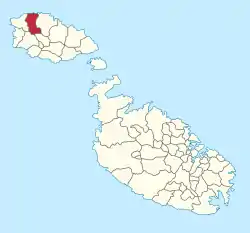
| District | Gozo and Comino District |
| Borders | Għarb, Kerċem, Victoria, Żebbuġ |
| Government | |
| • Mayor | Daniel Attard (PN) |
| Area | |
| • Total | 5 km2 (2 sq mi) |
| Population (Jan. 2019) | |
| • Total | 424 |
| • Density | 85/km2 (220/sq mi) |
| Demonym(s) | Għasri (m), Għasrija (f), Għasrin (pl) |
| Time zone | UTC+1 (CET) |
| • Summer (DST) | UTC+2 (CEST) |
| Postal code | GSR |
| Dialing code | 356 |
| ISO 3166 code | MT-16 |
| Patron saint | Corpus Christi |
| Day of festa | June |
| Website | Official website |
The village lies between the hills of Żebbuġ and Għammar. The name has Arabic origins and refers to the period of the day in between the afternoon and the evening. Għasri is reached by forking right on the Victoria-Għarb road just after the Aqueduct.
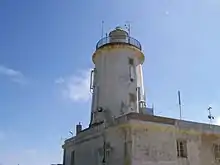
A lighthouse on Ġurdan hill, better known as the Giordan Lighthouse dominates Għasri. The famous lighthouse rises 180 metres above sea level and was inaugurated in 1853. Its beam can be seen up to 50 kilometres away. Upon the hill around the lighthouse there are some marvellous 360-degree views of Gozo and this lures many hikers, who ascend the steep path to the hilltop.
From the Village Square, a road leads to the fabulous valley of Wied il-Għasri. On the way, there are a number of typical farmhouses, most of them available for short or long lets, as well as an old charming chapel dedicated to the Patronage of the Blessed Virgin Mary. The Wied il-Għasri area is a marvelous country walk or cycling site especially in Winter and Spring. The valley ends in the sea, wedged between high cliffs where a secluded little inlet makes it ideal for swimming, snorkelling and diving. Indeed, the sea around Wied il-Għasri is very popular among divers. In Għasri valley one can find some saltpans.
The village church, designed by a local priest, Dun Ġużepp Diacono, was built early in the twentieth century. Its foundation stone was laid on 6 September 1903 and it was dedicated to the Corpus Christi, otherwise known as Christ the Saviour in the Eucharist on 9 January 1916. The village was established a parish by Bishop Giovanni Maria Camilleri on 16 December 1921.
Għasri Main Roads
- Pjazza Salvatur (Corpus Christi Square)
- Triq il-Fanal (Lighthouse Street)
- Triq il-Wilġa (Daleland Street)
- Triq iż-Żebbuġ (Zebbug Road)
- Triq Salvu Gambin (S. Gambin Street)
- Triq Dun Karm Caruana (Fr.Carmelo Caruana Street)
Other Streets at Għasri
- Daħla Ta' Għammar (Għammar Street)
- Sqaq il-Knisja (Church Alley)
- Sqaq Wied tal-Qattus (Cat's Valley Alley)
- Trejqet Ġesù Nazzarenu (Jesus of Nazareth Path)
- Trejqet il-Farfett tal-Korpus (Corpus Butterfly Path)
- Triq id-Dehra (Apparition Street)
- Triq il-Ġonna (Gardens Street)
- Triq il-Knisja (Church Street)
- Triq il-Maxrabija (Maxrabija Street)
- Triq it-Tamar (Dates Street)
- Triq l-Għarb (Għarb Road)
- Triq Ta' Għammar (Għammar Road)
- Triq Ta' Pinu (Ta' Pinu Road)
- Triq Tal-Fenek (Tal-Fenek Road)
- Triq Tal-Kanun (Tal-Kanun Road)
- Triq Wied l-Għasri (Għasri Valley Road)
- Triq Wied Sara (Sahra Valley Road)
- Wesgħa Dun Ġużepp Buttigieg (Fr. Joseph Buttigieg Place)
References
- "Estimated Population by Locality 31st March, 2014". Government of Malta. 16 May 2014. Archived from the original on 21 June 2015.
- "Twinning". localgovernment.gov.mt. Government of Malta. Retrieved 18 September 2019.
External links
| Wikimedia Commons has media related to Għasri. |
- Għasri Local Council Website
- Photo of Wied L-Ghasri
- Photo of Wied il-Għasri taken from the staircase cut into the rock
| Malta Local councils |
| |
|---|---|---|
| Malta Administrative committees |
| |
| Gozo Local councils | ||
| Gozo Administrative committees | ||