Gabiley
Gabiley (Somali: Gabiley, Arabic: غابيلي), also known as Gebiley, is a city in the Maroodi Jeex region of Somaliland.[2][3][4]
Gabiley
غابيلي | |
|---|---|
City | |
.svg.png.webp) Gabiley Location in Somaliland | |
| Coordinates: 9°42′0″N 43°37′25″E | |
| Country | |
| Region | Maroodi Jeex |
| District | Gabiley |
| Government | |
| • Mayor | Mahamed-Amin Omar Abdi |
| Population | |
| • Total | 106,914[1] |
| Time zone | UTC+3 (EAT) |
Gabiley is located 58 km west of Hargeisa, the capital of Somaliland. It is in the center of the Gabiley district, bounded on the north by the Gulf of Aden, on the west by the Awdal region, on the east by the Hargeisa district, and on the south by the Somali Region of Ethiopia.[5]
Townships
The majority of the people in the district have been settled there for the last 300 years. There are more major and minor towns in Gabiley district than anywhere else in Somaliland.[6]
Major towns:
- Gabiley, district capital of the region
- Wajaale
- Arabsiyo
- Kalabaydh
- Allaybaday
Minor towns:
- Agabar
- El Bardale
- Ceel-Sheekh
- Galooley
- Harcadaad
- Geedbalaadh
- Galadweyne
- Argeegta
- Teysa
- Xidhinta
- Ijaara
- Boqor
- Bus
- AliHaydh
- Gogeysa
- GeedAbeera
History
Gabiley is one of the oldest towns in Somaliland after Zeila, Berbera and Amud. Some stones left behind in the area were believed to have been earmarked for the construction of pyramids.[7]
Demographics
The town of Gabiley has a population of around 106,914.[1]
The Gabiley District in which the city is situated is inhabited by people from the Somali ethnic group, with the Jibril Abokor subclan of the Habr Awal the main residents of this district.[8][9][10]
Education
Primary schools, Secondary schools and University education is available throughout the district. The smaller communities have their own primary schools. For post-secondary education, Timacade University was opened in 1999 to serve the needs of the town's students. The education system in Gabiley region is growing in a faster pace than most of Somaliland.[11]
Healthcare
Gabiley has 5 operating general hospital. One massive hospital opened in 2010, it provides medical services to the larger region.
In 2016 the municipal government was led by Mahamed-Amiin Omer Abdi who is the current mayor of Gabiley city and the governor of Gabiley region.[12]
Agriculture
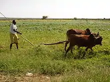
Gabiley is the main farm land for Somaliland and produces up to 85% of Somaliland's food supplies. It is known for its agricultural and farming industry, and is where most of Somaliland's crops are produced. Crops grown in the area include apples, oranges, bananas, corn, pears, maize, wheat, barley, beans, lemon, peas, groundnuts, potatoes, tomatoes, onions, garlic, salad and cabbages, broccoli, watermelon, papaya and many other types of fruits and vegetables. Gabiley is considered to be the most fertile region in Somaliland.[6]
Climate
The climate here is considered to be a local steppe climate. There is not much rainfall in Gabiley all year long. According to Köppen-Geiger system, this climate is classified as (BSh). In Gabiley, the average annual temperature is 21.4 °C. The average annual rainfall is 489 mm. The driest month is December, with 2 mm of rain. In August, the precipitation reaches its peak, with an average of 91 mm. June is the warmest month of the year. The temperature in June averages 24.5 °C. At 17.6 °C on average, January is the coldest month of the year. There is a difference of 89 mm of precipitation between the driest and wettest months. The variation in annual temperature is around 6.9 °C.
| Climate data for Gabiley | |||||||||||||
|---|---|---|---|---|---|---|---|---|---|---|---|---|---|
| Month | Jan | Feb | Mar | Apr | May | Jun | Jul | Aug | Sep | Oct | Nov | Dec | Year |
| Average high °C (°F) | 24.6 (76.3) |
26.1 (79.0) |
28.1 (82.6) |
28.6 (83.5) |
29.9 (85.8) |
30.7 (87.3) |
29.2 (84.6) |
29.2 (84.6) |
29.9 (85.8) |
27.9 (82.2) |
26 (79) |
24.2 (75.6) |
27.9 (82.2) |
| Average low °C (°F) | 10.6 (51.1) |
12.2 (54.0) |
14.4 (57.9) |
16.2 (61.2) |
17.4 (63.3) |
18.3 (64.9) |
17.8 (64.0) |
17.6 (63.7) |
17.4 (63.3) |
14.4 (57.9) |
12.2 (54.0) |
11.2 (52.2) |
15.0 (59.0) |
| Average precipitation mm (inches) | 4 (0.2) |
11 (0.4) |
33 (1.3) |
74 (2.9) |
63 (2.5) |
36 (1.4) |
73 (2.9) |
91 (3.6) |
76 (3.0) |
18 (0.7) |
8 (0.3) |
2 (0.1) |
489 (19.3) |
| Source: Climate-Data.org, altitude: 1460m[13] | |||||||||||||
Notable residents
- Abdillahi Suldaan Mohammed Timacade, prominent Somali poet during the pre- and post-colonial period from Galooley who conducted public readings in the area. He belongs to the Ali Jibril (Reer Hareed) sub-clan of the Jibril Abokor clan.
- Mohamed Hasan Abdullahi, former Chief of Staff of Somaliland Armed Forces and SNM General. He belongs to the Ali Jibril (Reer Dalal) sub-clan of the Jibril Abokor clan.
- Mo Farah, British four-time Olympic gold medalist and the most decorated athlete in British athletics history; belongs to the Muhammed Jibril (Deriyahan) sub-clan of the Jibril Abokor clan.[14]
- Nuh Ismail Tani, current Chief of Staff of Somaliland Armed Forces. He belongs to the Ali Jibril (Reer Hareed) of the Jibril Abokor clan.
References
- "Population Estimation Survey 2014 For the 18 Prewar regions of Somalia" (PDF).
- "Issue 270". Retrieved 28 March 2016.
- "The Transitional Federal Charter of the Somali Republic" (PDF). University of Pretoria. 1 February 2004. Archived from the original (PDF) on 25 March 2009. Retrieved 2 February 2010.
- https://books.google.co.uk/books?id=pAeuDwAAQBAJ&pg=PA152&lpg=PA152&dq=kalabaydh+somalia&source=bl&ots=NDF6Ol_YE4&sig=ACfU3U1f_reZIKhL40i28N-PFXmTS6DSLA&hl=en&sa=X&ved=2ahUKEwj9k-vNwrPnAhWEsnEKHXcABF44HhDoATAGegQICRAB#v=onepage&q=kalabaydh%20somalia&f=false.
- Districts of Somalia, Statoids
- "Gabiley Travel Guide". World66.com. Archived from the original on 30 September 2007. Retrieved 12 April 2015.
- The Archaeology of Islam in Sub Saharan Africa, p. 72/73
- http://www.refworld.org/docid/3ae6ab704.html
- Phillips, Sarah. "Political Settlements and State Formation: The Case of Somalia" (PDF). Archived from the original (PDF) on 2 February 2017. Retrieved 4 June 2017.
- Sommerlatte, Malte (2000). Ecological Assessment of the Coastal Plains of North Western Somalia (Somaliland). IUCN Eastern Africa Regional Office. p. 4.
The Issa Musa are the more coastal sub-clan of the Habr Awal, and they live in the immediate environs of Berbera and extend southwards to Hargeisa. West of them but in proximity are the Sa’ad Musa, who extend from a narrow strip on the coast near Bullaxaar and El Sheikh towards the towns of Gebile and Hargeisa which they dominate, and across into their grazing lands in the rich plateau area of the ‘Haud’ in Ethiopia.
- http://gabiley.net/2015/02/my-volunteer-experience-at-hargeisa-school-of-social-work-university-of-hargeisa/
- https://reliefweb.int/report/somalia/assessment-awdal-region-somaliland-11th-15th-dec-2016
- "Climate: Gabiley - Climate graph, Temperature graph, Climate table". Climate-Data.org. Retrieved 25 September 2013.
- "Mo Farah's family cheers him on from Somaliland village". The Guardian. Retrieved 13 March 2014.
External links
- Gabiley news (Somali)
- Gabiley - coordinates